Brian D
-
Posts
3,029 -
Joined
-
Last visited
Content Type
Profiles
Blogs
Forums
American Weather
Media Demo
Store
Gallery
Everything posted by Brian D
-
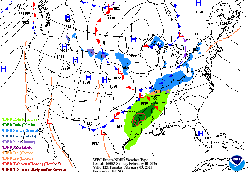
They finally updated weekly ice. This much ice (greater than 50%) for early Feb in the last 45 years doesn't happen often.
-
Ice conditions as of Feb 2. Pretty much a variety of ice thickness now. Here's the egg code interpretation page. Stage of development has one for sea ice, and one for lake ice. So make sure your looking at the right one. (Lake Ice) https://www.canada.ca/en/environment-climate-change/services/ice-forecasts-observations/publications/interpreting-charts/chapter-1.html
-
Cold morning with -10's/-20's inland with +/- sd's along the shore. -29 the lowest I've seen at Seagull Lake up on the border. Because of the clear, calm conditions, temps did a quick sunrise drop at some locales.
-
February 3 1989: Bitterly cold temperatures occur across Minnesota with lows in the 40-below-zero range in the north. 1947: A strong dust storm hits Crookston with winds near 50 mph. Visibility was reduced down to 300 feet. For Tuesday, February 3, 2026 1917 - Downtown Miami, FL, reported an all-time record low of 27 degrees. (David Ludlum) 1947 - The temperature at Tanacross, AK, plunged to a record 75 degrees below zero. (David Ludlum) 1987 - Wintry weather was confined to freezing drizzle and light snow in the northeastern U.S., and light rain and snow in the western U.S. (The National Weather Summary) 1988 - Arctic air continued to invade the central U.S. The temperature at Midland TX plunged from a record high of 80 degrees to 37 degrees in just three hours. Morning lows in the higher elevations of Wyoming were as cold as 38 degrees below zero. Heavy snow blanketed southwestern Colorado, with 16 inches reported at Steamboat Springs. (The National Weather Summary) (Storm Data) 1989 - A winter storm brought heavy snow and high winds to the western U.S. Up to three feet of snow blanketed the Sierra Nevada of California, and buried parts of northeastern Washington State under three feet of snow in five days. High winds across Washington State reached 75 mph, with gusts to 105 mph. (The National Weather Summary) (Storm Data) 1989 - Severe cold gripped the north central U.S. The morning low of 29 degrees below zero at Casper WY was a record for the month of February. Wisdom MT hit 53 degrees below zero. Missoula MT reported a wind chill reading of 85 degrees below zero. (The National Weather Summary) 1990 - Thunderstorms developing ahead of a cold front produced severe weather over the central Gulf coast states during the afternoon and evening hours. Thunderstorms spawned seven tornadoes in Alabama, including one which touched down north of Birmingham injuring fifteen people and causing nearly three million dollars damage. A tornado at Margaret injured eleven persons and caused a million dollars damage. (The National Weather Summary) (Storm Data)
-
February 2 1996: The all-time state record low temperature is set in Minnesota. With numerous media folk present, the low dips to -60 three miles south of Tower. Governor Arne Carlson cancelled school statewide due to the cold. 1988: The temperature bottoms out at -43 at Embarrass. 1927: Spring-like temperatures are felt on Groundhog Day. Tracy is 57 and Fairmont reaches 56. For Monday, February 2, 2026 1952 - The only tropical storm of record to hit the U.S. in February moved out of the Gulf of Mexico and across southern Florida. It produced 60 mph winds, and two to four inches of rain. (2nd-3rd) (The Weather Channel) 1956 - A record snowstorm in New Mexico and west Texas began on Ground Hog's Day. The storm produced 15 inches of snow at Roswell NM, and up to 33 inches in the Texas Panhandle. (David Ludlum) 1987 - A fast moving arctic front brought snow and high winds to the north central U.S. Winds gusted to 69 mph at Brookings SD. Big Falls MN reported nine inches of snow. Record warmth was reported just ahead of the front. Burlington IA reported a record high of 59 degrees. (The National Weather Summary) (Storm Data) 1988 - A dying low pressure system over southern California deluged the San Diego coastal mountains with more than four inches of rain causing half a million dollars damage. Arctic air invading the north central U.S. sent the mercury plunging to 38 degrees below zero at Park Rapids MN. Raleigh NC reported a record high of 75 degrees. (The National Weather Summary) (Storm Data) 1989 - Bitter cold air covered much of the central U.S. Butte MT reported a wind chill reading of 91 degrees below zero, Salt Lake City UT was blanketed with 11.9 inches of snow in 24 hours, and winds around Reno NV gusted to 80 mph. Unseasonably warm weather continued in the southeastern U.S. Twenty-eight cities reported record high temperatures for the date, including Wilmington NC with a reading of 80 degrees. (The National Weather Summary) (Storm Data) 1990 - Thunderstorms developing ahead of a cold front produced severe weather in the Lower Mississippi Valley during the late afternoon and evening hours. One person was injured in a tornado near Reidheimer LA. Thunderstorms northeast of Brandon MS produced hail three inches in diameter along with high winds which downed or snapped off one hundred trees. (The National Weather Summary) (Storm Data) 1996 - An Arctic outbreak that lasted from late January through early February produced nearly 400 hundred record lows, 15 all-time low readings, and over 50 new record lows. Four states recorded their all-time record low temperatures, including Tower, Minnesota, on this date with a reading of 60 degrees below zero, canceling Tower's annual Icebox Days festival because it is too cold. Locations that reported their all-time record low or tied included: Cresco, IA: -36°, Osage, IA: -34°, Charles City, IA tied their record low with -32° and Lancaster, WI tied their all-time record low with -31°. International Falls, MN, and Glasgow, MT set records for February with -45° and -38°, respectively. The temperature at Embarrass, MN, plummeted to -53°. Rochester, MN, dipped to -34° for its coldest temperature in 45 years. Green Bay, WI only reached -16° for the high temperature for the day, their coldest 2006 - New Orleans is struck by two tornadoes, collapsing at least one previously damaged house and battering Louis Armstrong International Airport. <a href="http://islandnet.com/~see/weather/almanac/diaryfeb.htm">The Weather Doctor</a> 2008 - Hilo, HI, is deluged by 10.82 inches of rain in a period of 24 hours, breaking the previous record set in 1969 by 3.5 inches. <a href="http://islandnet.com/~see/weather/almanac/diaryfeb.htm">The Weather Doctor</a> 2011 - A high temperature of 44°F registered at Sky Harbor Airport in Phoenix, AZ, sets an all-time February record for the coldest high temperature for the city. <a href="http://islandnet.com/~see/weather/almanac/diaryfeb.htm">The Weather Doctor</a> That stretch in 1996 was the worst to endure. Schools shutdown for a week. The sawmill I worked at shutdown, as well. Hydraulic fluid gelled. Heaters couldn't keep up. Highs -10's to -20's, and lows -30's to -50's with -60 as the state record. WICKED COLD! Also reminds me of some folks new to the N always asked why there were electric cords hanging out the front of the grills of cars. Engine block heaters was a new concept to them.
-
0.7" of snow imby yesterday. 1"+ inland. Next event is showing some mix come Thurs.
-
Decent call. Front moves across the N, with LP moving along the S sub Tues, bringing more snow to the OHV region.
-
Light snow moving through today. Might even mix with a little frz drz later. Looks like there is already some up N mixed in from a NWS DLH update. Best snow up around Grand Marais with some Lake help. SW flow does them well.
-
February 1 1931: A 'heat wave' develops across southern Minnesota. St. Peter hits 60. For Sunday, February 1, 2026 1893 - Thunder and lightning accompanied sleet and snow at Saint Louis MO during the evening hours, even though the temperature was just 13 degrees above zero. (The Weather Channel) 1951 - The greatest ice storm of record in the U.S. produced glaze up to four inches thick from Texas to Pennsylvania causing twenty-five deaths, 500 serious injuries, and 100 million dollars damage. Tennessee was hardest hit by the storm. Communications and utilities were interrupted for a week to ten days. (David Ludlum) 1951 - The temperature at Taylor Park Dam plunged to 60 degrees below zero, a record for the state of Colorado. (Sandra and TI Richard Sanders - 1987) 1985 - Snow, sleet and ice glazed southern Tennessee and northern sections of Louisiana, Mississippi and Alabama. The winter storm produced up to eleven inches of sleet and ice in Lauderdale County AL, one of the worst storms of record for the state. All streets in Florence AL were closed for the first time of record. (1st-2nd) (The Weather Channel) 1987 - A storm in the Pacific Northwest produced wind gusts to 100 mph at Cape Blanco OR, and up to six inches of rain in the northern coastal mountain ranges. (The National Weather Summary) (Storm Data) 1988 - Thirty cities in the eastern U.S. reported new record high temperatures for the date, including Richmond VA with a reading of 73 degrees. Thunderstorms in southern Louisiana deluged Basile with 12.34 inches of rain. Arctic cold gripped the north central U.S. Wolf Point MT reported a low of 32 degrees below zero. (The National Weather Summary) (Storm Data) 1989 - While arctic cold continued to invade the central U.S., fifty-four cities in the south central and eastern U.S. reported new record high temperatures for the date. Russell KS, the hot spot in the nation with a high of 84 degrees the previous day, reported a morning low of 12 above. Tioga ND reported a wind chill reading of 90 degrees below zero. (The National Weather Summary) 1990 - Thunderstorms associated with an upper level weather disturbance produced severe weather across the eastern half of Texas during the late afternoon and evening. Four persons were injured at Waco TX where thunderstorms produced wind gusts to 80 mph. Thunderstorms produced wind gusts to 97 mph at Cotulla TX injuring two other persons. Golf ball size hail was reported at Whitney and northeast of Whitsett. (The National Weather Summary) (Storm Data) 2011 - One of the most significant events of the 2010-2011 winter season affected a widespread region from Texas to the Midwest and Northeast from February 1st to 3rd 2011. The system produced widespread heavy snow with blizzard conditions and significant freezing rain and sleet to other locations. Snowfall amounts of 10 to 20 inches were common from northeast Oklahoma to lower Michigan. The storm produced 20.2 inches at Chicago, the third heaviest snowfall in the city since their records began in 1886, along with a peak wind of 61 mph. Kansas City received just under 9 inches of snow. The high temp was 17 degrees.
-
"NO Chances" Guess your totally SOL!
-
January 31 1893: The temperature drops 40 degrees in five hours during a blizzard at Park Rapids. For Saturday, January 31, 2026 1911 - Tamarack, CA, was without snow the first eight days of the month, but by the end of January had been buried under 390 inches of snow, a record monthly total for the U.S. (The Weather Channel) 1949 - The temperature at San Antonio, TX, plunged to a record low of one degree below zero. Helena MT reached 42 degrees below zero. (David Ludlum) 1966 - A blizzard struck the northeastern U.S. When the storm came to an end, twenty inches of snow covered the ground at Washington D.C. (David Ludlum) 1969 - Minnesota experienced many winter storms throughout the month of 1969, where several people had died from heart attacks and auto accidents. Many roads were blocked or iced over several times during the month. Considerable snow during January and frequent periods of strong winds resulted in many days of blowing and drifting snow across northeast South Dakota. There were also many days with freezing rain. The most significant icing occurred on the 22nd and the 27th. There were numerous days where the traffic was at a standstill due to blocked roads and closed airports. Many school closings occurred throughout the month, with many activities canceled. Many rural roads went long periods without being opened, resulting in hardships for farmers. 1982 - A snowstorm struck Missouri, Illinois and Indiana. Twenty-five inches of snow at Greenville IL, located east of Saint Louis, paralyzed the community. The storm left 4000 motorists stranded for two days. (David Ludlum) 1987 - A storm in the Pacific Northwest produced wind gusts to 85 mph in Oregon, and nearly two inches of rain in twelve hours in the Puget Sound area of Washington State. Ten inches of snow at Stampede Pass WA brought their total snow cover to 84 inches. (National Weather Summary) (Storm Data) 1988 - Thirty-one cities in the central and northeastern U.S. reported new record high temperatures for the date, with many occurring during the early morning hours. Temperatures in western New York State reached the 60s early in the day. Strong northerly winds in the north central U.S. produced wind chill readings as cold as 60 degrees below zero in North Dakota. (National Weather Summary) 1989 - The barometric pressure at Norway, AK, reached 31.85 inches (1078.4 mb) establishing an all-time record for the North American Continent. The temperature at the time of the record was about 46 degrees below zero (The Weather Channel). Severe arctic cold began to invade the north central U.S. The temperature at Great Falls MT plunged 85 degrees in 36 hours. Valentine NE plummeted from a record high of 70 degrees to zero in just nine hours. Northwest winds gusted to 86 mph at Lander WY, and wind chill readings of 80 degrees below zero were reported in Montana. Sixty-four cities in the central U.S. reported record highs for the date as readings reached the 60s in Michigan and the 80s in Kansas. (National Weather Summary) (Storm Data) 1990 - High winds in Montana on the 28th, gusting to 77 mph at Judith Gap, were followed by three days of snow. Heavy snow fell over northwest Montana, with up to 24 inches reported in the mountains. An avalanche covered the road near Essex with six feet of snow. Snow and high winds also plagued parts of the southwestern U.S. Winds gusted to 54 mph at Show Low AZ, and Flagstaff AZ was blanketed with eight inches of snow. (National Weather Summary) (Storm Data)
-
-10's/-20's inland with +/- sd's along the shore this morning. Looks like 1-2" possibly 3" of snow for tomorrow across the broader region here. Forecast is for 1" here in TH. Stats for Jan here in TH: max avg 16.9 (23.7), min avg 1.2 (7.4), mean avg 9.1 (15.6), precip 0.67" (1.04"), and snow 10.3" (14.7"). Since Oct, precip sits at 2.79" (ranked 10th driest). Going to need some wet months this year or else drought severity will continue to worsen.
-

Winter 2025-26 Medium/Long Range Discussion
Brian D replied to michsnowfreak's topic in Lakes/Ohio Valley
Looking at really long range for next winter. This is what it's looking like to me atm. Dec 2026 - mixed pattern with a cold start, and finish to the month (+/- near avg) Jan 2027 - most of the month looks rather cold until the last week or so (well below avg) Feb 2027 - mixed pattern with a cold ending (near/above avg) Should be another interesting winter -
This would be an awesome. CO low moving into the neighborhood would be welcome! I saw potential, soooo.....LET IT BE SO!
-
January 30 1994: Duluth has a record low of -35. For Friday, January 30, 2026 1936 - Birmingham, AL, established a single storm record and 24 hour record with 11 inches of snow. (29th-30th) (David Ludlum) (The Weather Channel) 1966 - The Blizzard of 1966 impacted New York and paralyzed the region. The train service was disrupted. Numerous highways, the New York State Thruway from Albany to the Pennsylvania state line, and the Buffalo Airport and other airports throughout western and central New York were closed. The Syracuse-Oswego area's hardest hit, where Bob Sykes, a meteorology professor at the State University of New York at Oswego, reported a whopping 102.4 inches! Some schools in Orleans County were closed for the entire week following the blizzard. Economic loss from the storm was estimated at $35 million. Winds gusting to 60 mph and temperatures in the teens, and heavy and blowing snow created severe blizzard conditions. 1977 - The great "Buffalo Blizzard" finally abated after three days. The storm added a foot of new snow to 33 inches already on the ground. Winds gusting to 75 mph reduced visibilities to near zero, produced snow drifts twenty-five feet high, and kept wind chill readings 50 degrees below zero. The blizzard paralyzed the city, and caused 250 million dollars damage. (David Ludlum) 1987 - A winter storm brought more heavy snow to the North Atlantic Coast Region, with 13.6 inches reported at Hiram ME. January proved to be the snowiest of record for much of Massachusetts. Worcester MA reported an all-time monthly record of 46.8 inches of snow. (National Weather Summary) 1988 - Strong southerly winds, gusting to 53 mph at Kansas City MO, spread warm air into the central U.S. Nineteen cities reported record high temperatures for the date. Snow and strong northwest winds ushered cold arctic air into the north central states. The temperature at Cutbank plunged from 54 degrees to a morning low of 7 degrees below zero. (National Weather Summary) 1989 - The temperature at McGrath, AK, dipped to 62 degrees below zero, and Fairbanks reported a reading of 51 degrees below zero, with unofficial readings in the area as cold as 75 degrees below zero. The massive dome of bitterly cold air began to slide down western Canada toward the north central U.S. Strong southwest winds ahead of the arctic front pushed the temperature at Great Falls MT to 62 degrees, and gusted to 124 mph at Choteau MT, overturning trucks and mobile homes, and a dozen empty railroad cars. (National Weather Summary) (Storm Data) 1990 - A major winter storm produced heavy snow from Indiana to New England. It was the biggest storm in two and a half years for eastern New York State. Snowfall totals in the mountains of Maine ranged up to 20 inches at Guilford and Lovell. Other heavy snowfall totals included 17 inches at Utica NY, and 19 inches at Bethel VT, Ludlow VT, and New London NH. The storm claimed three lives in eastern New York State, and four lives in Vermont. (National Weather Summary) (Storm Data) 2002 - One of the driest Januarys on record in Iowa was broken up by a winter storm that produced snowfall across the state from January 30-31. The snow was heaviest across southern and southeastern Iowa, where storm total accumulations ranged between 11 and 13 inches along and south of Chariton�s line through Ottumwa to Wapello and Burlington. The highest reported totals were 13.2 inches at Leon and 13.0 inches at Bloomfield and Fairfield. 2005 - A significant ice storm struck parts of northern Georgia on the 30th-31st. Ice accretion was as great as 2 inches in Monroe county, located southeast of Atlanta. Power outages in the area at the height of the storm affected nearly 320,000 homes and businesses.
-
-sd's along the shore with -10's/-20's inland. Some -30's near the border with Seagull Lake the winner at -38. After tomorrow morning, we should be back to avg temps for a while (20's/+/-sd's). 1-2" snowfall expected Sun, so that'll be a nice change.
-
January 29 1977: Due to the extreme cold, the St. Paul Winter Carnival is held indoors for the first time. For Thursday, January 29, 2026 1780 - On the coldest morning of a severe winter the mercury dipped to 16 degrees below zero at New York City, and reached 20 degrees below zero at Hartford CT. New York Harbor was frozen for five weeks, allowing a heavy cannon to be taken across the ice to fortify the British on Staten Island. (The Weather Channel) 1921 - A small but intense windstorm resulted in the "Great Olympic Blowdown" in the Pacific Northwest. Hurricane force winds, funneled along the mountains, downed vast expanses of Douglas fir trees, and the storm destroyed eight billion board feet of timber. Winds at North Head WA gusted to 113 mph. (David Ludlum) 1947 - On this date through the 30th, a fierce winter storm buried southern Wisconsin under two feet of snow. Strong northeasterly winds piled drifts up to 10 feet high in the Milwaukee area, shutting down the city for two days. 1983 - A series of Pacific coast storms finally came to an end. The storms, attributed in part to the ocean current, "El Nino," produced ocean swells 15 to 20 feet high which ravaged the beaches of southern California. Much of the damage was to homes of movies stars in the exclusive Malibu Colony. (The Weather Channel) 1987 - A strong storm moving out of the Central Rockies spread snow across the north central states, with up to eight inches of snow in Wisconsin, and produced wind gusts to 64 mph at Goodland KS. A thunderstorm produced three inches of snow in forty-five minutes at Owing Mills MD. (National Weather Summary) (Storm Data) 1988 - Rain and snow were primarily confined to the northwestern U.S. An afternoon reading of 34 degrees at International Falls MN was a record high for the date. (National Weather Summary) (Storm Data) 1989 - Bitter cold air continued to pour into Alaska. At McGrath, temperature dipped to 63 degrees below zero. Strong winds blowing through the Alaska Range between Fairbanks and Anchorage produced a wind chill reading of 120 degrees below zero at Cantwell. (National Weather Summary) 1990 - Severe thunderstorms in the southeastern U.S. spawned a tornado which destroyed three mobile homes near Blythe GA injuring six persons. A fast moving cold front produced high winds in the western U.S. Winds along the coast of Oregon gusted to 65 mph at Portland, and high winds generated 22 to 26 foot seas which battered the coast. Winds near Reno NV gusted to 78 mph. High winds also buffeted the Central High Plains, with gusts to 94 mph reported at La Mesa CO. (National Weather Summary) (Storm Data) 2002 - A major three-day winter storm blasted parts of Kansas and Missouri. A catastrophic ice storm occurred south of the snow area, with two inches of ice and snow accumulating in the Kansas City, Missouri area. Thousands of trees were felled by the storm, blocking roads, felling utility lines, and causing fires. Two "Bicentennial Trees," estimated at being over 200 years old, were badly damaged from this storm. After the 31st, 325,000 people were reported without power in Kansas City alone. 2008 - A sharp cold front moved across Illinois during the day, producing a drastic temperature drop. Temperatures fell 20 to 40 degrees in just a couple of hours, with areas from Springfield, Illinois to St. Louis, Missouri seeing temperatures fall as much as 50 degrees between noon and 6 pm. Temperatures in the mid-60s in central Illinois at midday on the 29th had fallen to near zero by the next morning.
-
Well ahead of the curve with Lake ice.
-
Pixie dust falling today. "T" day. Chilly out with -sd's/-10's this morning. Ely/Seagull Lake areas were in the -20's. Looks like the Bemidji/Park Rapids areas were as well. But this will be more like it, and might even get an inch of snow Sun.
-
Snowbirders flee that stuff. This year, it's following them.
-
January 28 1914: A very rare thunderstorm (for this time of year) is observed at Maple Plain during the evening. Heavy thunder and vivid lightning was observed. 1846: Temperatures are not too shabby for a January day. The high in the Twin Cities was 50, which is the normal high for the beginning of March. For Wednesday, January 28, 2026 1887 - Snowflakes "as large as milk pans" fell at Fort Keogh of Montana. The flakes, which were said to measure 15 inches across and 8 inches thick, hold the unofficial size record! 1922 - The "Knickerbocker" storm immobilized the city of Washington D.C. The storm produced 28 inches of snow in 32 hours, and the heavy snow caused the roof of the Knickerbocker movie theatre to collapse killing 96 persons. (David Ludlum) 1963 - The low of -34 degrees at Cynthiana, KY, equalled the state record established just four days earlier at Bonnieville. (The Weather Channel) 1969 - Heavy rains of tropical origin that began on 1/18 ended on this day. As much as 50 inches of rain fell at 7,700 feet. 31 inches of rain fell on the south slopes of Mt. San Gorgonio, 15.5 inches at San Jacinto Peak, around ten inches at Banning, less than one inch from Indio southeast. 91 were reported dead from flooding and mudslides all over California and state-wide. 1977 - The Blizzard of '77 was one of the worst winter storms to hit southern Ontario and upstate New York. With the rapid onset of the storm, about 2,000 students in the Niagara region were stranded overnight in schools. 1987 - A storm moving out of the Central Rockies into the Northern Plains Region produced up to a foot of snow in the Colorado Rockies, and wind gusts to 99 mph at Boulder CO. High winds in Colorado caused 5.6 million dollars damage. (National Weather Summary) (Storm Data) 1988 - Barometric pressure readings of 30.55 inches at Miami FL, 30.66 inches at Tampa FL, and 30.72 inches at Apalachicola FL were all-time record high readings for those locations. (National Weather Summary) 1989 - Nome, AK, reported an all-time record low reading of 54 degrees below zero, and the temperature at Fairwell AK dipped to 69 degrees below zero. Deadhorse AK reported a morning low of 49 degrees below zero, and with a wind chill reading of 114 degrees below zero. In the Lower Forty-eight States, a winter storm over Colorado produced up to 15 inches of snow around Denver. (National Weather Summary) (Storm Data) 1990 - Strong and gusty winds prevailed across the northwestern U.S., and heavy snow continued over the mountains of Washington State and Oregon. In Idaho, Mullan received seven inches of snow, and winds gusted to 65 mph southeast of Burley. Heavy rain soaked coastal sections of western Oregon. Rainfall totals of 1.20 inches at Portland and 1.57 inches at Eugene were records for the date. Winds in Oregon gusting to 60 mph downed power lines in Umatilla County knocking out power to more than 13,000 homes, just prior to the kick-off of the "Super Bowl" game. (National Weather Summary) (Storm Data) That 1846 high of 50 would still be standing today, as the record high for Jan 28 in MSP is 47 (1892/2025). In fact, January as whole in 1846 still holds the record at 29.0, but the official record is 28.6 (2006). It was, in fact, noted that 1846 was the warmest year in the 1800's. Very warm!
-
Guess I didn't realize it was still that cold down that way. Not paying attention with other stuff I've been doing. Stay warm
-
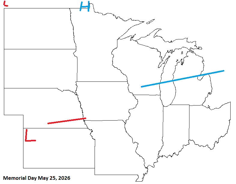
Memorial Day is showing a threat of shwrs/stms. Possible some energy from the W may sneak along the boundary. But the pattern for late May actually looks rather cool, so it may get shunted south if it does move out. The weekend in general looks bookended with frontal activity.
-
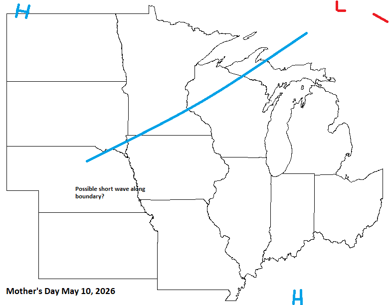
Mother's Day looks to be similar to May Day with a strong front moving through our sub.
-
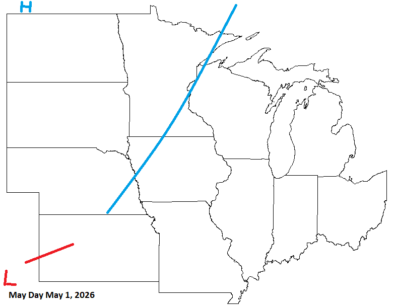
On May Day, look for a strong cold front moving through our sub. Shwrs/stms could get a bit squirrelly.