PaulyFromPlattsburgh
-
Posts
532 -
Joined
-
Last visited
Content Type
Profiles
Blogs
Forums
American Weather
Media Demo
Store
Gallery
Everything posted by PaulyFromPlattsburgh
-
Upstate/Eastern New York
PaulyFromPlattsburgh replied to BuffaloWeather's topic in Upstate New York/Pennsylvania
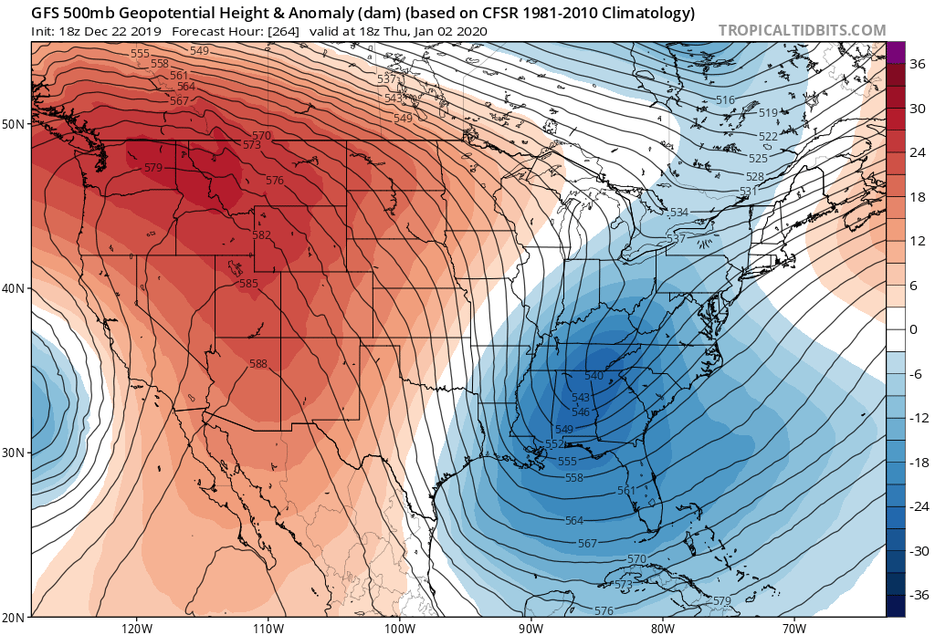
You can see much better ridge placement on the 12z vs previous runs. The western shortwave is slightly weaker and rotates further southwest instead of getting sucked into the flow allowing more pieces from the north to funnel down. Looks like a very interesting run ahead. I can’t post images for some reason. At HR168 you can see the PJ halted for a sec there stopping those building heights. At HR 180 you can see that SW about 150 miles west mitigating the flow. significant LE event for many. -
Upstate/Eastern New York
PaulyFromPlattsburgh replied to BuffaloWeather's topic in Upstate New York/Pennsylvania
You ain’t kidding just wild -
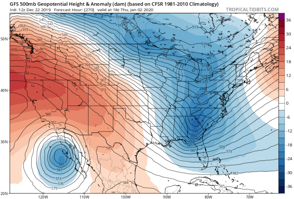
From January 4th onto about the 7th GFS brings in some record cold! Nice polar connection during that period halting the PJ for a few days at least
-
Upstate/Eastern New York
PaulyFromPlattsburgh replied to BuffaloWeather's topic in Upstate New York/Pennsylvania
January 4th on extreme cold per the GfS -
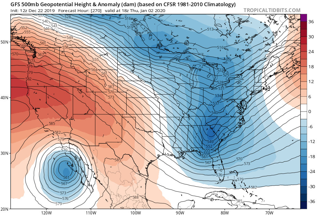
18z looks much better. That SW retrograding into the pacific vs previous runs thus allowing a beautiful ridge to build in to create some space for digging. This run was close to a bomb for many.
-
Upstate/Eastern New York
PaulyFromPlattsburgh replied to BuffaloWeather's topic in Upstate New York/Pennsylvania
18z wants to retrograde that SW back into the pacific thus allowing anice ridge to build in. Vs previous runs. 18z too 12z bottom. I see good trends coming
-
Upstate/Eastern New York
PaulyFromPlattsburgh replied to BuffaloWeather's topic in Upstate New York/Pennsylvania
I like the euro solution lol! Gives me 6 inches -
2010. The same year snowmageddon dropped 30 inches 50 miles to my south with zilch where I am when I was living in NYC.
-
I remember this one. Short range models killed it. SREF, RUC, RAP, HRRR especially! I remember we had a raging +NAO also!
-
Upstate/Eastern New York
PaulyFromPlattsburgh replied to BuffaloWeather's topic in Upstate New York/Pennsylvania
Euro and CMC both slightly amplify that northern stream Alberta clipper dropping 1-3/2-4 in northern areas -
Upstate/Eastern New York
PaulyFromPlattsburgh replied to BuffaloWeather's topic in Upstate New York/Pennsylvania
https://www.cpc.ncep.noaa.gov/products/precip/CWlink/MJO/mjoupdate.pdf just came out today good read -
Upstate/Eastern New York
PaulyFromPlattsburgh replied to BuffaloWeather's topic in Upstate New York/Pennsylvania
lol those are 85ps. what do you expect with a strong ridge in place at the time lol. quick torch in and out but surface will still hang on to below freezing, at night at least.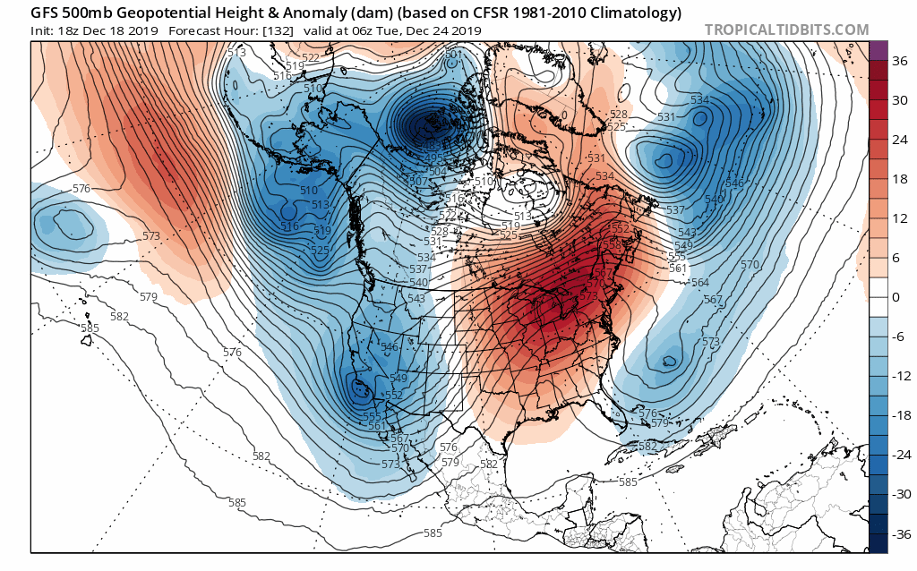
-
Upstate/Eastern New York
PaulyFromPlattsburgh replied to BuffaloWeather's topic in Upstate New York/Pennsylvania
GFS really making nice trends long range by building that ridge out west vs 18z. liking this look! HR 300 top and 27o bottom. as you can see big trends. hmmm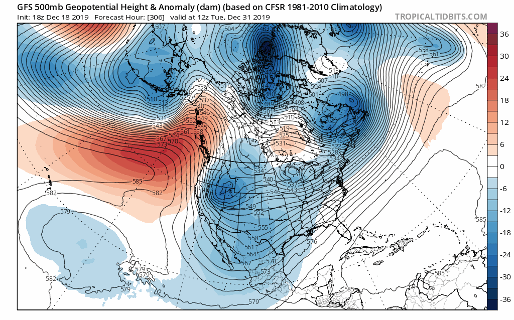

-
Upstate/Eastern New York
PaulyFromPlattsburgh replied to BuffaloWeather's topic in Upstate New York/Pennsylvania
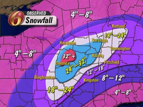
Oh man did they bust. Most areas got around 6 around here. They seem to be acknowledging the mistake on Facebook. The models weren’t great but many accidents could have been avoided with at least a WWA!
-
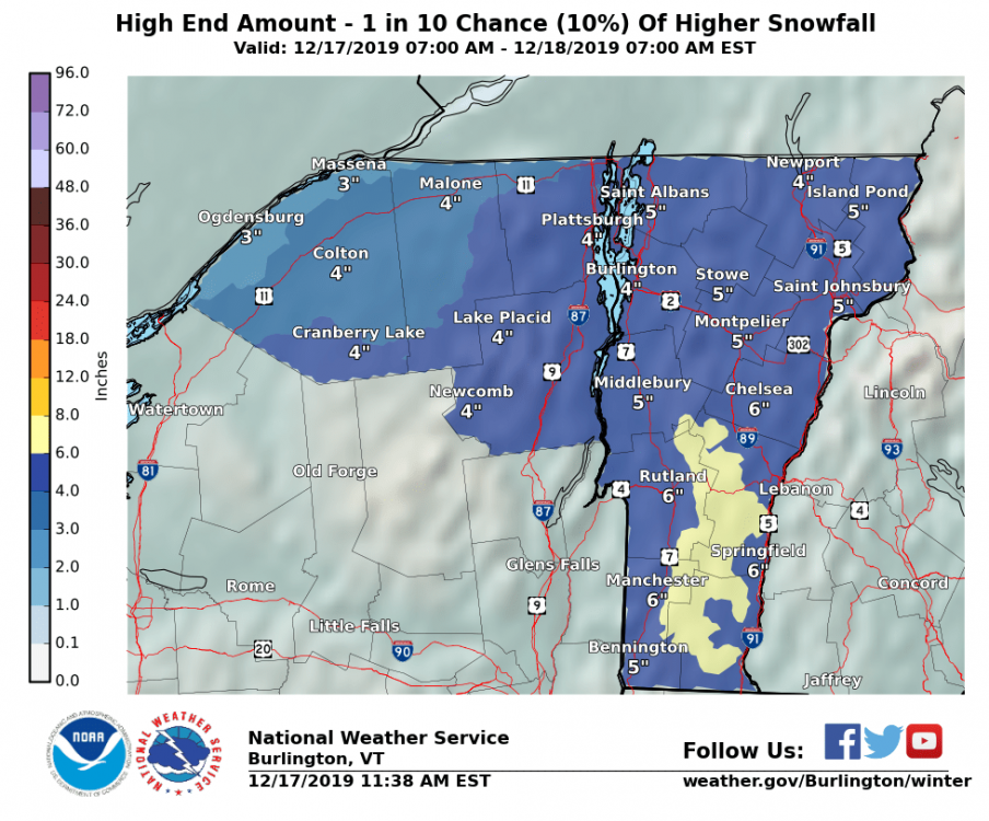
12/17 Messy Mix - Observations/Nowcast
PaulyFromPlattsburgh replied to Baroclinic Zone's topic in New England
I am close to 6 inches of snow in Plattsburgh. Mid level magic is right! -
Upstate/Eastern New York
PaulyFromPlattsburgh replied to BuffaloWeather's topic in Upstate New York/Pennsylvania
Big flakes under green returns again. Consistent snow for 10 hours now! Closing in on 6 inches!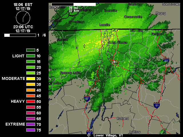
-
Upstate/Eastern New York
PaulyFromPlattsburgh replied to BuffaloWeather's topic in Upstate New York/Pennsylvania
Everyone winning in one way or another. Snow to date based on pivotal maps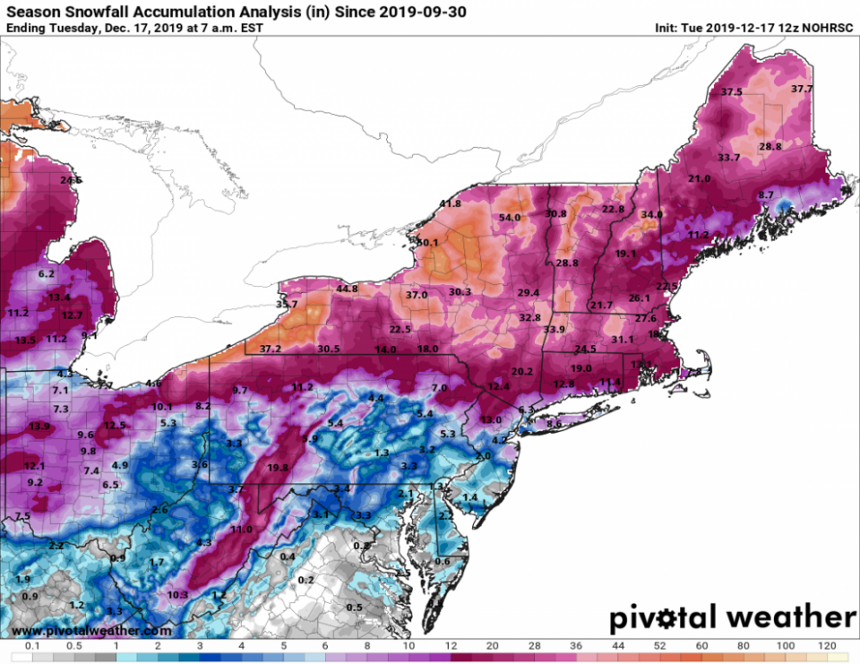
-
Upstate/Eastern New York
PaulyFromPlattsburgh replied to BuffaloWeather's topic in Upstate New York/Pennsylvania
It’s a glitch . Bad glitch look st this . Bottom one is frame before yours!
-
Mid to Long Term Discussion 2019
PaulyFromPlattsburgh replied to Upstate Tiger's topic in Southeastern States
Strong line coming
-
Upstate/Eastern New York
PaulyFromPlattsburgh replied to BuffaloWeather's topic in Upstate New York/Pennsylvania
Exactly 3.0 inches here in the Champlain valley plattsburgh. Pretty low elevation 150ft -
Upstate/Eastern New York
PaulyFromPlattsburgh replied to BuffaloWeather's topic in Upstate New York/Pennsylvania
Dare I say I like a SWFE more the southern virga of a nor’easter. Lol -
12/17 Messy Mix - Observations/Nowcast
PaulyFromPlattsburgh replied to Baroclinic Zone's topic in New England
3.0 inches in plattsburgh. Coming down nice. -
Upstate/Eastern New York
PaulyFromPlattsburgh replied to BuffaloWeather's topic in Upstate New York/Pennsylvania
Juicy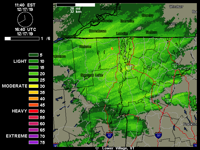
-
12/17 Messy Mix - Observations/Nowcast
PaulyFromPlattsburgh replied to Baroclinic Zone's topic in New England
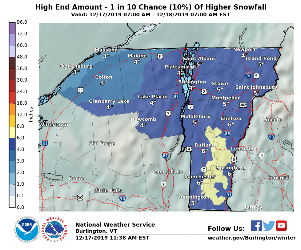
Yes I am in plattsburgh getting smoked. I am in those yellow returns. No WWA in the area very surprised. We need a station in plattsburgh and not depend on VT -
Upstate/Eastern New York
PaulyFromPlattsburgh replied to BuffaloWeather's topic in Upstate New York/Pennsylvania
solid snow band just formed right on top of me. No wind. Lovely. The best forcing 700mb at least is close to my area hence the enhancement