PaulyFromPlattsburgh
-
Posts
532 -
Joined
-
Last visited
Content Type
Profiles
Blogs
Forums
American Weather
Media Demo
Store
Gallery
Everything posted by PaulyFromPlattsburgh
-
Upstate/Eastern New York
PaulyFromPlattsburgh replied to BuffaloWeather's topic in Upstate New York/Pennsylvania
That looks great for my area. -
Upstate/Eastern New York
PaulyFromPlattsburgh replied to BuffaloWeather's topic in Upstate New York/Pennsylvania
Now that is what we like to see -
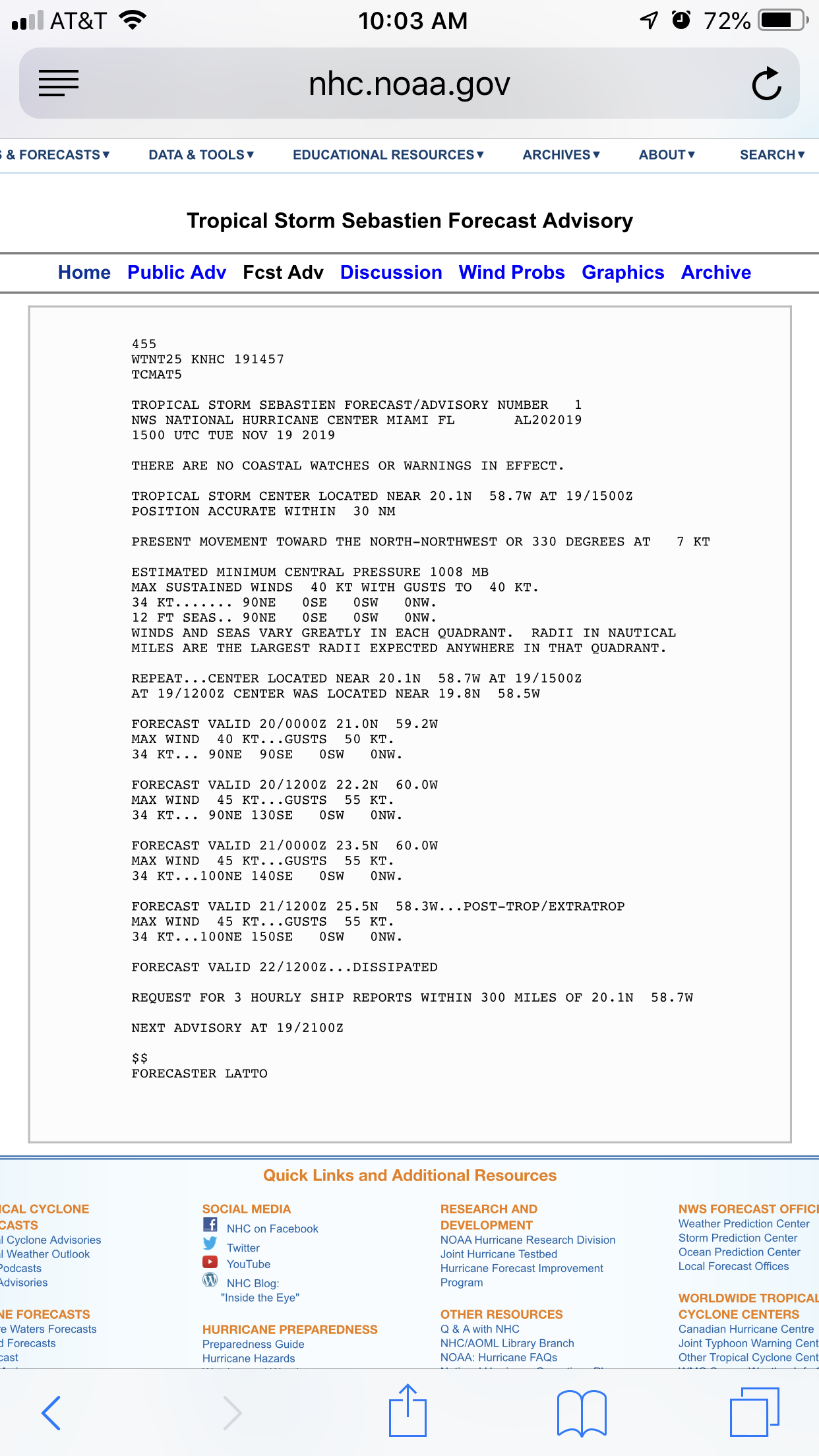
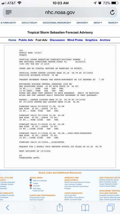
Sebastien has formed in the open Atlantic.
-
Upstate/Eastern New York
PaulyFromPlattsburgh replied to BuffaloWeather's topic in Upstate New York/Pennsylvania
Does anyone with more scientific weather knowledge please tell me what a long lasting cutoff low at 500-700mb in the BAJA peninsula means for formation of low pressures in our area. Thank you. If it’s cut off from the flow would it even matter? I’m assuming not -
Upstate/Eastern New York
PaulyFromPlattsburgh replied to BuffaloWeather's topic in Upstate New York/Pennsylvania
And the ICON caves. I would write this one off for western NY. Central upstate NY Adirondacks might be in for a quick 1-3 as rain transitions to snow. Unless models move this west. Gonna be some fun tracking at least. It’s early in the season and many of us are spoiled, including me. I would gladly take another inch to whiten the ground up. -
Upstate/Eastern New York
PaulyFromPlattsburgh replied to BuffaloWeather's topic in Upstate New York/Pennsylvania
Huge differences at 500mb between icon and gfs. Icon really wants to energize this piece of energy and closes off over Upstate NY while the GfS keeps it open at upper levels from what I’m seeing. -
Upstate/Eastern New York
PaulyFromPlattsburgh replied to BuffaloWeather's topic in Upstate New York/Pennsylvania
NAVGEM FWIW shows some sort of retrograding low big hit on days 5-6. Maybe other models will folllow suit. Split flow pattern ahead looms like. -NAO holding on -
Upstate/Eastern New York
PaulyFromPlattsburgh replied to BuffaloWeather's topic in Upstate New York/Pennsylvania
Heavy band. Big flakes. Can’t see nothing. Loving it -
Stowe does have nice elevation. But yes I agree. U could see the taint come close as the low comes close on the HrRR
-
Upstate/Eastern New York
PaulyFromPlattsburgh replied to BuffaloWeather's topic in Upstate New York/Pennsylvania
How do you read this? Looks interesting and resourceful -
Upstate/Eastern New York
PaulyFromPlattsburgh replied to BuffaloWeather's topic in Upstate New York/Pennsylvania
Filling in nice. Syracuse gonna get some lovin’ real soon. Off topic but Ganges Michigan. Drag band right now. Foot of snow expected there in the next 6-10 hours... love the lake effect that comes of Lake Michigan. Jealous I never experienced late effect. It must feel so different from synoptic with those insane rates -
November 2019 General Discussions & Observations Thread
PaulyFromPlattsburgh replied to Rtd208's topic in New York City Metro
Latest HRRR says what snow? Rain till the end in NYC. Delays the first snow. Bummer surface is boiling. I miss living in Brooklyn but I know winter is not going to be like it was the past ten years, every year. U get used to it sadly. I am used to having lots of snow living in NYC 2010-2018. Moved upstate and am cashing in Right now in northern Ny. -
I am just south east of that heavier band in sciota.Extreme Northern NY IS CASHING IN RIGHT NOW
-
Upstate/Eastern New York
PaulyFromPlattsburgh replied to BuffaloWeather's topic in Upstate New York/Pennsylvania
Just went to shovel. Snow is very heavy and wet. Ratios likely 9-10:1 at max. Deff windy and beautiful. I am just south east of a heavier band in Sciota New York. Dry slot not too far.in between subsidence and the good stuff -
Yes it is lovely.
-
Upstate/Eastern New York
PaulyFromPlattsburgh replied to BuffaloWeather's topic in Upstate New York/Pennsylvania
I go there now. Love the school. Not much in synoptic the last 5 years with lots of coastal for areas like the I95 corridor. This year the low pressures seem to be cutting a little more. A low going through central NY is prime for areas like northern adirondacks but that dry slot is trouble fro central NY in those cases. -
2.5 inches here. I am low elevation by the lake
-
Upstate/Eastern New York
PaulyFromPlattsburgh replied to BuffaloWeather's topic in Upstate New York/Pennsylvania
I am low elevation by Cumberland bay. Across the street from Champlain lake. At 2.5 inches currently. Elevation around 140 feet. Champlain valley, no lake effect here. Only luck is synoptic. -
Thank you for the warm welcome. Will measure now and get back to you. Always happy to do some OBS. 22 Degrees at the moment.
-
Upstate/Eastern New York
PaulyFromPlattsburgh replied to BuffaloWeather's topic in Upstate New York/Pennsylvania
Thank you for the warm welcome. I love weather and track models on tropical tidbits as a hobby. Hopefully I can be of some help here. You guys are awesome by the way. Great conversations and always amazing insight. Past two years lurking have been tough. I’m glad I’m no longer a lurker. I never knew I could post without paying for a membership. Lol stupid me -
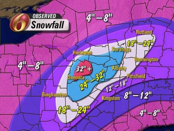
Heavy snow. 22 degrees in Plattsburgh NY. Expecting 12 inches
-
Depends where. Would say dry slotting more of an issue if anything for some areas
-
22 degrees here with heavy snow. Banding developing well ahead of the low. Been lurking for years but decided to post since Plattsburgh NY and the North Country are in prime position for snows. Heavy snow ripping in Plattsburgh NY. Look like I lucked out. Bullseye. Expecting 12 inches.
-
Upstate/Eastern New York
PaulyFromPlattsburgh replied to BuffaloWeather's topic in Upstate New York/Pennsylvania
I been lurking here for 2 years now. I am in prime position for this snowstorm in upstate NY . Plattsburgh NY region. Hoping for 12 inches. Currently at 2.5 inches and banding developing well ahead of the low. For me at least liking like a bullseye