PaulyFromPlattsburgh
-
Posts
532 -
Joined
-
Last visited
Content Type
Profiles
Blogs
Forums
American Weather
Media Demo
Store
Gallery
Everything posted by PaulyFromPlattsburgh
-
Upstate/Eastern New York
PaulyFromPlattsburgh replied to BuffaloWeather's topic in Upstate New York/Pennsylvania
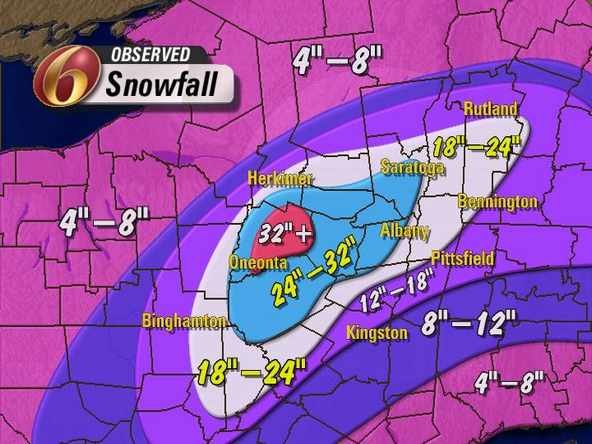
I need this looks so cool. Enjoy wolfie you deserve it -
Upstate/Eastern New York
PaulyFromPlattsburgh replied to BuffaloWeather's topic in Upstate New York/Pennsylvania
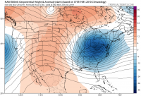
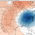
Could be worse. Here is Alaska from yesterday’s 6z. Wouldn’t want to be there right now. Crazy how they had record warmth in the summerX. Now have extreme cold. And still on pace for warmest year on record!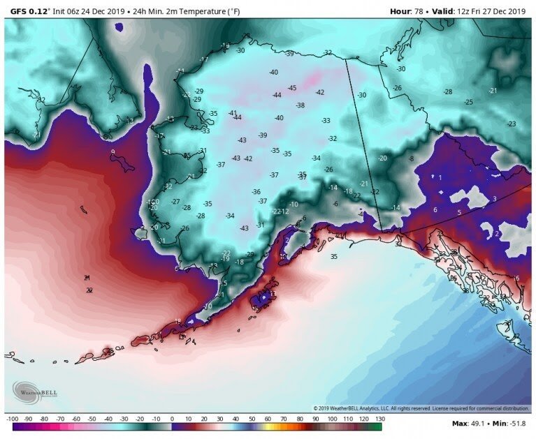
-
Upstate/Eastern New York
PaulyFromPlattsburgh replied to BuffaloWeather's topic in Upstate New York/Pennsylvania
GFS surface temps 2m same time. Nice warm up. GFS even shows NYC hitting close to 60 on December 30th -
Upstate/Eastern New York
PaulyFromPlattsburgh replied to BuffaloWeather's topic in Upstate New York/Pennsylvania
It finally worked. But look. That’s indicative of some strong AO rise. +15-20’surface temps into Canada based on last thirty year analogs. -
Upstate/Eastern New York
PaulyFromPlattsburgh replied to BuffaloWeather's topic in Upstate New York/Pennsylvania
Maine wins on a solution like that and cashes In from all three lows! -
Upstate/Eastern New York
PaulyFromPlattsburgh replied to BuffaloWeather's topic in Upstate New York/Pennsylvania
I can’t post images but looks at the 2m anamolies into Canada late run on the CMC! Very warm I don’t like it -
Upstate/Eastern New York
PaulyFromPlattsburgh replied to BuffaloWeather's topic in Upstate New York/Pennsylvania
Wow also the three low solution. Models have to figure this out . I highly doubt this will occur verbatim. Lol looks like a disorganized mess with that stupid SW sitting there spinning for days after the initial storm with a very warm flow depiction late run CMC. I hear the AO is going to rise to record high anamolies and had a chance of hitting + 3-5’in first two weeks of January -
Upstate/Eastern New York
PaulyFromPlattsburgh replied to BuffaloWeather's topic in Upstate New York/Pennsylvania
The 12z CMC is something I have never seen before. Forms the initial low in Texas which reforms in Michigan which reforms again off of cape cod . Three times!! It’s squished and the energy just breaks off. Interesting depiction -
Upstate/Eastern New York
PaulyFromPlattsburgh replied to BuffaloWeather's topic in Upstate New York/Pennsylvania
GFS identical through 78 -
Upstate/Eastern New York
PaulyFromPlattsburgh replied to BuffaloWeather's topic in Upstate New York/Pennsylvania
Yes lol, the question is who do we trust. The Germans Canadians or Americans! -
Upstate/Eastern New York
PaulyFromPlattsburgh replied to BuffaloWeather's topic in Upstate New York/Pennsylvania
I just looked at the Canadian. And it has a nice bowling ball look for sure! Gets shunted south at first allowing some space for the ULL to pass to the south of the region and dig more. Verbatim CMC is s solid snowstorm as is -
Upstate/Eastern New York
PaulyFromPlattsburgh replied to BuffaloWeather's topic in Upstate New York/Pennsylvania
Wow the CMC is mighty close to a big hit for many!!! -
Upstate/Eastern New York
PaulyFromPlattsburgh replied to BuffaloWeather's topic in Upstate New York/Pennsylvania
Long range GFS is setting up for a major Synoptic snowstorm wow! 1050 MB canadian high! s there a reason I can’t post images. Said it’s to big? I’m mad lol -
1050 HP high north of main long range. I think it will be cold and lots of chances for snow. Agree to disagree
-
That was insane. I will never forget that when the ULL captured it and brought it back. I think the 12z NAM started the trend tho. The run before
-
By Hr 264 a pacific zonal flow develops. But you can also see a small piece of energy breaking off that southern SW likely going to down a storm day 11! Makes me think the cold will be halted this run for sure. . In fact the long range part of this run 10days on looks pretty bleh. Mainly Zonal flow . Artic shortwave not digging down into Canada.nearly as much .long range wobbling. We will see. Everyone run drastically differently. Analyzing is fun but obviously taken with a grain of salt. Small storm forms day 11 which looks pretty good early on. Piece of energy gets funneled from SW across country to the easternshortwave . Crazy how weather works Gives everyone on this board some snow! Happy tracking
-
Upstate/Eastern New York
PaulyFromPlattsburgh replied to BuffaloWeather's topic in Upstate New York/Pennsylvania
happy holidays to all by the way! -
Upstate/Eastern New York
PaulyFromPlattsburgh replied to BuffaloWeather's topic in Upstate New York/Pennsylvania
By Hr 264 a pacific zonal flow develops. But you can also see a small piece of energy breaking off that southern SW likely going to down a storm day 11! Makes me think the cold will be halted this run for sure. . In fact the long range part of this run 10days on looks pretty bleh. Mainly Zonal flow . Artic shortwave not digging down into Canada.nearly as much .long range wobbling. We will see. Everyone run drastically differently. Analyzing is fun but obviously taken with a grain of salt. Small storm forms day 11 which looks pretty good early on. Piece of energy gets funneled from SW across country to the easternshortwave . Crazy how weather works Gives everyone on this board some snow! Happy tracking -
Upstate/Eastern New York
PaulyFromPlattsburgh replied to BuffaloWeather's topic in Upstate New York/Pennsylvania
The omega block at 240 is really allowing that shortwave to dig into FL! -
Upstate/Eastern New York
PaulyFromPlattsburgh replied to BuffaloWeather's topic in Upstate New York/Pennsylvania
It’s not gonna make it this run but I love the look. Ridge into the Rockies at hour 234. Looks like yesterday’s 18z lol -
You can see much better ridge placement on the 12z vs previous runs. The western shortwave is slightly weaker and rotates further southwest instead of getting sucked into the flow allowing more pieces from the north to funnel down. Looks like a very interesting run ahead. I can’t post images for some reason. At HR168 you can see the PJ halted for a sec there stopping those building heights. At HR 180 you can see that SW about 150 miles west mitigating the flow. Gfs wobbling back and forth on where to put that SW. by keeping the SW further west we allow for a better polar connection as evident on 12 z starting at 168 compared to previous runs. On top of that the whole evolution of what happens after day 7 is skewed. The 6z will use that SW to build the next storm while the 12z will extrapolate a whole different solution. I would rather have that SW hold back a bit tbh, HR 192 that SW about 250 miles east of 12z by Texas while it was in the eastern pacific on 6z. From 168-198 u can see 12z just dropping in northern wave short wave troughs. At 216 classic look nice ridge out west. Trough digging. SW not joining the flow. He 228 ridge into the Rockies and trough keeps digging. Not gonna make it this run, but a good look to start
-
Upstate/Eastern New York
PaulyFromPlattsburgh replied to BuffaloWeather's topic in Upstate New York/Pennsylvania
HR 216 GFS is classic honestly -
You can see much better ridge placement on the 12z vs previous runs. The western shortwave is slightly weaker and rotates further southwest instead of getting sucked into the flow allowing more pieces from the north to funnel down. Looks like a very interesting run ahead. I can’t post images for some reason. At HR168 you can see the PJ halted for a sec there stopping those building heights. At HR 180 you can see that SW about 150 miles west mitigating the flow. Gfs wobbling back and forth on where to put that SW. by keeping the SW further west we allow for a better polar connection as evident on 12 z starting at 168 compared to previous runs. On top of that the whole evolution of what happens after day 7 is skewed. The 6z will use that SW to build the next storm while the 12z will extrapolate a whole different solution. I would rather have that SW hold back a bit tbh, HR 192 that SW about 250 miles east of 12z by Texas while it was in the eastern pacific on 6z. From 168-198 u can see 12z just dropping in northern wave short wave troughs. You NYC boys will like this run day 9 on!
-
Upstate/Eastern New York
PaulyFromPlattsburgh replied to BuffaloWeather's topic in Upstate New York/Pennsylvania
Yes much better wind positioning and ULL for LE for you guys! Big run early on for the first shortwave. You can see much better ridge placement on the 12z vs previous runs. The western shortwave is slightly weaker and rotates further southwest instead of getting sucked into the flow allowing more pieces from the north to funnel down. Looks like a very interesting run ahead. I can’t post images for some reason. At HR168 you can see the PJ halted for a sec there stopping those building heights. At HR 180 you can see that SW about 150 miles west mitigating the flow. Gfs wobbling back and forth on where to put that SW. by keeping the SW further west we allow for a better polar connection as evident on 12 z starting at 168 compared to previous runs. On top of that the whole evolution of what happens after day 7 is skewed. The 6z will use that SW to build the next storm while the 12z will extrapolate a whole different solution. I would rather have that SW hold back a bit tbh, HR 192 that SW about 250 miles east of 12z by Texas while it was in the eastern pacific on 6z. From 168-198 u can see 12z just dropping in northern wave short wave troughs -
You can see much better ridge placement on the 12z vs previous runs. The western shortwave is slightly weaker and rotates further southwest instead of getting sucked into the flow allowing more pieces from the north to funnel down. Looks like a very interesting run ahead. I can’t post images for some reason. At HR168 you can see the PJ halted for a sec there stopping those building heights. At HR 180 you can see that SW about 150 miles west mitigating the flow. Gfs wobbling back and forth on where to put that SW. by keeping the SW further west we allow for a better polar connection as evident on 12 z starting at 168 compared to previous runs. On top of that the whole evolution of what happens after day 7 is skewed. The 6z will use that SW to build the next storm while the 12z will extrapolate a whole different solution. I would rather have that SW hold back a bit tbh, HR 192 that SW about 250 miles east of 12z by Texas while it was in the eastern pacific on 6z. From 168-198 u can see 12z just dropping in northern wave short wave troughs


