PaulyFromPlattsburgh
-
Posts
532 -
Joined
-
Last visited
Content Type
Profiles
Blogs
Forums
American Weather
Media Demo
Store
Gallery
Everything posted by PaulyFromPlattsburgh
-
Upstate/Eastern New York
PaulyFromPlattsburgh replied to BuffaloWeather's topic in Upstate New York/Pennsylvania
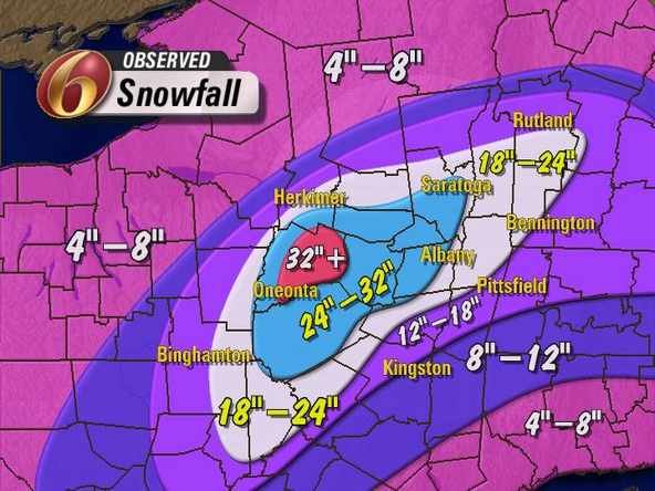
Wow the 6Z GFS was a huge hit for the Dacks!!! Huge Friday hit -
Upstate/Eastern New York
PaulyFromPlattsburgh replied to BuffaloWeather's topic in Upstate New York/Pennsylvania
GFS has now wobbled back south with the threats. I wouldn’t trust it at this point. Was so north last run now south with the overrunning storm 2 this run. Icon vice versa -
Upstate/Eastern New York
PaulyFromPlattsburgh replied to BuffaloWeather's topic in Upstate New York/Pennsylvania
Wow the ICON looks beautiful. Tons of overrunning! Low pressure circus train riding the front -
Upstate/Eastern New York
PaulyFromPlattsburgh replied to BuffaloWeather's topic in Upstate New York/Pennsylvania
Yes please!!!! -
Upstate/Eastern New York
PaulyFromPlattsburgh replied to BuffaloWeather's topic in Upstate New York/Pennsylvania
Yes please Dave . Beautiful . Pattern looks gradient based to an extent. -
Upstate/Eastern New York
PaulyFromPlattsburgh replied to BuffaloWeather's topic in Upstate New York/Pennsylvania
Haha I am very happy. I have not been on all day. But happy to see the pattern looks like it’s shifting in a better direction for the North country. -
Upstate/Eastern New York
PaulyFromPlattsburgh replied to BuffaloWeather's topic in Upstate New York/Pennsylvania
I would take 15. Haha -
Upstate/Eastern New York
PaulyFromPlattsburgh replied to BuffaloWeather's topic in Upstate New York/Pennsylvania
Lots of nice hits for Northern NY. Guess it’s going to depend exactly where that gradient pattern sets up. The way guidance has been this year, I wouldn’t trust any runs until 1-2 days out -
Yeh I like to keep banter to a minimum.personally. Some of these analysis are ludicrous. Looks like the ones with the green tag and red tag are the ones to listen to. Have a good night.
-
Really? A positive tilted weak trough bad positioned at that look good to you? What you looking at
-
Yeh he is wishcasting. Slightly annoying . Gets old quick. That H5 looks absolutely miserable. If you are looking for an amplified nor’easter that that matter
-
Partially right. But mainly Wrong. It didn’t phase because that ridge is much weaker than forecasted days ago. This storm is a goner. Next. The leading Vort is not the worry. No ridge. Equal zonal progressive shitty flow. No room for coupling and amplification
-
This Super Bowl threat is done
-
no one knows at this range. thats impossible to answer. no one is out of the game yet. Right now many solutions are on the table. All these SW have not been properly sampled yet either. patience.
-
if you wanna laugh look at what the JMA does between 120 and 144 on TT. blows up and retrogades
-
at 114 we have a solidified cutoff in the SW. that energy stays behind. deff different than previous runs in the handling of the SW
-
i see a cutoff low forming in southwestern texas buckling the flow
-
Upstate/Eastern New York
PaulyFromPlattsburgh replied to BuffaloWeather's topic in Upstate New York/Pennsylvania
Icon gives me 6-12 inches of snow wow! Strong storm big blizzard. What a run -
yes 1-3 is a solid hit this season. stop looking verbatim. storm track looked good that run. like mentioned before, we dont have cold air. need it to work out just right.
-
with a lack of cold air, 18z gfs was prob best case scenario for the coast. More west and they torch. East a miss. lots of factors. late phase this run
-
GFS is a solid hit for many on this subforum
-
yall might wanna check out the 12zNAVGEM evolution at 500mb also. thats a possibility also. another interesting possible solution. hr180 on the NAVGEM shows how easily this can become all NS if that SS slides east initially and faster FWIW JMA is also a hit and miss
-
if you look at the last four euro runs, we are consistently losing the confluence positive anamolies look in canada and sadly trending neutral to negative.. not a good sign. just one piece of the puzzle. CMC shows a slightly negative NAO while EURO is clearly slightly positive neutral just by looking at both models 500mb output heights south of Greenland.
-
also the -NAO is diminished versus the last two-3 euro runs. you can see those heights dropping south of greenland. yesterday at 12z we had positive anamolies in that region. Now its neutralish. also flatter EPO ridge. little things make a big difference
-
that west coast ridge moved significantly east this run. concerning


