PaulyFromPlattsburgh
-
Posts
532 -
Joined
-
Last visited
Content Type
Profiles
Blogs
Forums
American Weather
Media Demo
Store
Gallery
Everything posted by PaulyFromPlattsburgh
-
Upstate/Eastern New York
PaulyFromPlattsburgh replied to BuffaloWeather's topic in Upstate New York/Pennsylvania
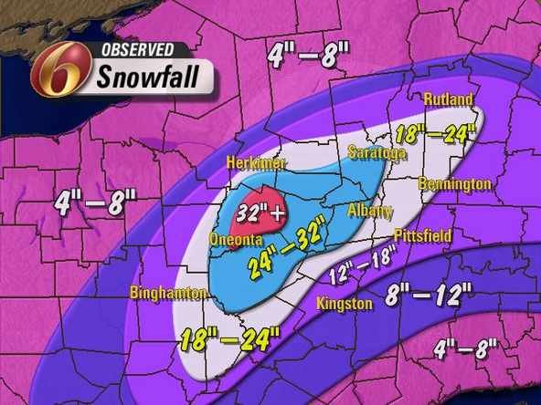
Looks like 6” with the first wave with another 2-4 with the second for Plattsburgh. I take -
Upstate/Eastern New York
PaulyFromPlattsburgh replied to BuffaloWeather's topic in Upstate New York/Pennsylvania
You are right. Oz GFS more amped so far but similar to 18z. Snow to ZR for Dacks with round 1. Round 2 is gonna be close. Prob rain to mix to snow -
Upstate/Eastern New York
PaulyFromPlattsburgh replied to BuffaloWeather's topic in Upstate New York/Pennsylvania
NAM at 84 is digging so Hard it’s in NYC while GFS same run is just a flatter cold front look progressively speeding into Maine. Maybe it’s on to something . It’s slows it down the whole flow . I’m staying up for 0z and certainly will be up for 6z. Dave thanks for rooting for snow up my way also! -
Upstate/Eastern New York
PaulyFromPlattsburgh replied to BuffaloWeather's topic in Upstate New York/Pennsylvania
I’m in plattsburgh. Northern Dacks. Looks fine . 4-6 inches with wave one looks like a good first call for my area. Wave 2 is still debatable as now the NAM amps this up to sub 985But you are right. Your area gets torched. Kitchen sink -
Upstate/Eastern New York
PaulyFromPlattsburgh replied to BuffaloWeather's topic in Upstate New York/Pennsylvania
Wow 12KM is so different from 32km it’s crazy. Let’s worry about wave 1 first. It’s a solid hit. Wave 2 is snow for many in the way the temps are orienting. I take -
Upstate/Eastern New York
PaulyFromPlattsburgh replied to BuffaloWeather's topic in Upstate New York/Pennsylvania
Are we looking at the same run? Big hit for many. 12 Km -
Upstate/Eastern New York
PaulyFromPlattsburgh replied to BuffaloWeather's topic in Upstate New York/Pennsylvania
Many will be happy with the NaM -
Upstate/Eastern New York
PaulyFromPlattsburgh replied to BuffaloWeather's topic in Upstate New York/Pennsylvania
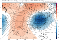
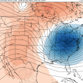
Pretty amped at 57 and a tad west. Might be just enough for a big hit for many. We will see. Mixing already into cleavland and parts of southern Ontario. Ooff.. 500mb shows evidence of more digging as 540 goes into northern texas. Sharper trough. -
Upstate/Eastern New York
PaulyFromPlattsburgh replied to BuffaloWeather's topic in Upstate New York/Pennsylvania
I know . I been doing this for years. Like the rest of us. Haha. -
Upstate/Eastern New York
PaulyFromPlattsburgh replied to BuffaloWeather's topic in Upstate New York/Pennsylvania
NAM looks a bit more amped through 45 -
Upstate/Eastern New York
PaulyFromPlattsburgh replied to BuffaloWeather's topic in Upstate New York/Pennsylvania
NAM running I will try to update everyone who won’t have a chance to access models tonight! Good evening all -
Upstate/Eastern New York
PaulyFromPlattsburgh replied to BuffaloWeather's topic in Upstate New York/Pennsylvania
I actually really like how the NAM looks at 84 for northern Dacks. 4-6 down from first wave with more from round 2! -
Upstate/Eastern New York
PaulyFromPlattsburgh replied to BuffaloWeather's topic in Upstate New York/Pennsylvania
EURO actually looks not half bad. Drops 6-12 over both storms for a majority of the region -
Upstate/Eastern New York
PaulyFromPlattsburgh replied to BuffaloWeather's topic in Upstate New York/Pennsylvania
These seem to be some type of pacific warm high pressure systems. Ridging strong positive anamoly high pressure system. Weird. Anamaolous . No clue myself. Theory -
Upstate/Eastern New York
PaulyFromPlattsburgh replied to BuffaloWeather's topic in Upstate New York/Pennsylvania
More also that the flow is super progressive giving it no time to amplify. -
Upstate/Eastern New York
PaulyFromPlattsburgh replied to BuffaloWeather's topic in Upstate New York/Pennsylvania
NAM is trending in the right direction. Decent hit -
Upstate/Eastern New York
PaulyFromPlattsburgh replied to BuffaloWeather's topic in Upstate New York/Pennsylvania
Is the wife a weather weenie as well? Haha -
Upstate/Eastern New York
PaulyFromPlattsburgh replied to BuffaloWeather's topic in Upstate New York/Pennsylvania
Very nice. -
Upstate/Eastern New York
PaulyFromPlattsburgh replied to BuffaloWeather's topic in Upstate New York/Pennsylvania
seems like they dont wanna create panic with a very iffy forecast! Smart move i think. Excuse my use of contractions. To used to facebook talk. lol -
Upstate/Eastern New York
PaulyFromPlattsburgh replied to BuffaloWeather's topic in Upstate New York/Pennsylvania
It looks decent for an ensemble. The discrepancies are noise. I liked the 12z Suites for the most part. Onto 18z -
Upstate/Eastern New York
PaulyFromPlattsburgh replied to BuffaloWeather's topic in Upstate New York/Pennsylvania
The way this year is going this will probably end up being the whole damn meal -
Upstate/Eastern New York
PaulyFromPlattsburgh replied to BuffaloWeather's topic in Upstate New York/Pennsylvania
That’s a nice CCB. Beautiful 850mb frontogenesis -
Upstate/Eastern New York
PaulyFromPlattsburgh replied to BuffaloWeather's topic in Upstate New York/Pennsylvania
Yes this run is a solid hit! -
Upstate/Eastern New York
PaulyFromPlattsburgh replied to BuffaloWeather's topic in Upstate New York/Pennsylvania
Wow the 6Z GFS was a huge hit for the Dacks!!! Huge Friday hit -
Upstate/Eastern New York
PaulyFromPlattsburgh replied to BuffaloWeather's topic in Upstate New York/Pennsylvania
GFS has now wobbled back south with the threats. I wouldn’t trust it at this point. Was so north last run now south with the overrunning storm 2 this run. Icon vice versa

