PaulyFromPlattsburgh
-
Posts
532 -
Joined
-
Last visited
Content Type
Profiles
Blogs
Forums
American Weather
Media Demo
Store
Gallery
Everything posted by PaulyFromPlattsburgh
-
Upstate/Eastern New York
PaulyFromPlattsburgh replied to BuffaloWeather's topic in Upstate New York/Pennsylvania
This might be the storm of the decade for many in NNE! It’s obviously the only one of the decade so far -
Upstate/Eastern New York
PaulyFromPlattsburgh replied to BuffaloWeather's topic in Upstate New York/Pennsylvania
wow! Most excited i have been since the November footer. -
Upstate/Eastern New York
PaulyFromPlattsburgh replied to BuffaloWeather's topic in Upstate New York/Pennsylvania
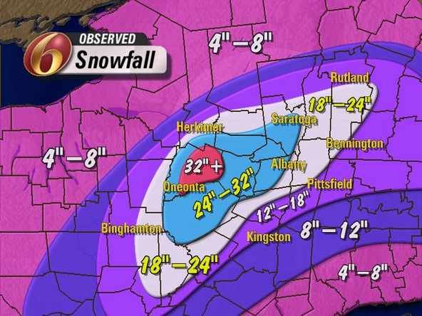
drops 16-22 inches across a large area of the dacks -
Upstate/Eastern New York
PaulyFromPlattsburgh replied to BuffaloWeather's topic in Upstate New York/Pennsylvania
I agree 700mb most important. and plenty cold. WAA quickly moves out after first overunning batch -
Upstate/Eastern New York
PaulyFromPlattsburgh replied to BuffaloWeather's topic in Upstate New York/Pennsylvania
Not that it matters much but the ICON has cut back some for round 2. and looked less wound up and more east. FWIW -
Upstate/Eastern New York
PaulyFromPlattsburgh replied to BuffaloWeather's topic in Upstate New York/Pennsylvania
Not like 0z was but a big hit for the dacks as well. Time to start the storm prep! I will start looking at short range Meso models tonight to see where best lifting and banding may occur. What’s good to see that all the models are showing is Plattsburgh will likely not see a lull at all but instead get 36 hours of straight snow -
Upstate/Eastern New York
PaulyFromPlattsburgh replied to BuffaloWeather's topic in Upstate New York/Pennsylvania
Once again the H5 is digging more yet again for round 2. Might even be stronger than last few runs. Pretty far west also with the second developing low as its being captured by the trough and bombing out -
Upstate/Eastern New York
PaulyFromPlattsburgh replied to BuffaloWeather's topic in Upstate New York/Pennsylvania
Yes look amazing’ Looks like they are also noting the potential for a CCB band with round 2. -
Upstate/Eastern New York
PaulyFromPlattsburgh replied to BuffaloWeather's topic in Upstate New York/Pennsylvania
ICON really delivers the goods. That CCB over the dacks is nice. Thats 2 inches an hour easy -
Upstate/Eastern New York
PaulyFromPlattsburgh replied to BuffaloWeather's topic in Upstate New York/Pennsylvania
ICON is also very strong. Clearly whatever data was ingested into 0z wants to dig that trough more allowing a stronger and more wound up system to develop. -
Upstate/Eastern New York
PaulyFromPlattsburgh replied to BuffaloWeather's topic in Upstate New York/Pennsylvania
with more to come. that is pretty much non stop for the dacks. neat. Thanks for the graphics as usual. -
Upstate/Eastern New York
PaulyFromPlattsburgh replied to BuffaloWeather's topic in Upstate New York/Pennsylvania
The capture from hr 60 to 63 is beautiful to watch and if correct will deliver 1-2 inch snowfall rates across a large chunk of the area. -
Upstate/Eastern New York
PaulyFromPlattsburgh replied to BuffaloWeather's topic in Upstate New York/Pennsylvania
Congrats upstate NY forum cause if the NAM is right we all will be VERY happy -
Upstate/Eastern New York
PaulyFromPlattsburgh replied to BuffaloWeather's topic in Upstate New York/Pennsylvania
OMG crushed 986MB than jumped to 984 as Norther stream caught in. What a weenie run . BIG hit for many -
Upstate/Eastern New York
PaulyFromPlattsburgh replied to BuffaloWeather's topic in Upstate New York/Pennsylvania
HR 54 precip shield filling in. I have not stopped snowing since hr33. This is gonna slam a lot in the forum. 990 rapidly blowing bomb in NC. THIS trough went negative at 48 and it was game on from there. Involving decent polar air from NS when it went negative. Storm one in Nova Scotia and storm 2 undergoing RI -
Upstate/Eastern New York
PaulyFromPlattsburgh replied to BuffaloWeather's topic in Upstate New York/Pennsylvania
994 at hour 48. This wants to blow up. Had that look early on. Just look at that H5 digging into the gulf aiding development Storm 1 off cape cod. Storm 2 in the south. Rock and roll boys. Neutral ready to tilt negative at 48 -
Upstate/Eastern New York
PaulyFromPlattsburgh replied to BuffaloWeather's topic in Upstate New York/Pennsylvania
If the NAM is correct Plattsburgh doesnt dry slot at all. Nice area of lift passing through at 45 before round 2. Air is moist and ready to go. Trough in gulf of mexico. Lots of convection associated with this. RGEM and other mesos show that well already. AT 45 trough is digging nice. This is usually a very nice look. I would take that H5 any winter day. Further south trough digs more energy and moisture i believe we can funnel into the SW -
Upstate/Eastern New York
PaulyFromPlattsburgh replied to BuffaloWeather's topic in Upstate New York/Pennsylvania
I am very amped.Round 2 is brewing on the NAM. Trough is sharper. This is gonna be big. -
Upstate/Eastern New York
PaulyFromPlattsburgh replied to BuffaloWeather's topic in Upstate New York/Pennsylvania
better lift!? Sorry. In amped I meant a stronger overunning look. But in fact it ended up looking weaker now that the run went on.colder for sure though.Time for round 2. -
Upstate/Eastern New York
PaulyFromPlattsburgh replied to BuffaloWeather's topic in Upstate New York/Pennsylvania
NAM coming in amped for western NY and cold with 1st wave. Hoping for a big hit for all of us. NAM at 28 certainly looks better for western NY than last run. Overunning substantially better through 33 on 12km. more expansive shield slightly weaker system -
Upstate/Eastern New York
PaulyFromPlattsburgh replied to BuffaloWeather's topic in Upstate New York/Pennsylvania
I agree. We are traumatized. But like you said trends and time are on our side. For once we are trending the right way. -
Upstate/Eastern New York
PaulyFromPlattsburgh replied to BuffaloWeather's topic in Upstate New York/Pennsylvania
Yes we are in a really good spot at this point. Latest guidance even the GFS shows upwards of 10 inches from both combined. -
Upstate/Eastern New York
PaulyFromPlattsburgh replied to BuffaloWeather's topic in Upstate New York/Pennsylvania
I’m in heaven. Plattsburgh special -
Upstate/Eastern New York
PaulyFromPlattsburgh replied to BuffaloWeather's topic in Upstate New York/Pennsylvania
CMC is a beauty! 10-12 easy -
Upstate/Eastern New York
PaulyFromPlattsburgh replied to BuffaloWeather's topic in Upstate New York/Pennsylvania
I’m not putting much weight into the ICON. It’s consistently been wrong at every forecast interval this whole storm if you play back the runs. The only thing the ICON is consistently good at is being wrong

