Gino27
-
Posts
556 -
Joined
-
Last visited
Content Type
Profiles
Blogs
Forums
American Weather
Media Demo
Store
Gallery
Everything posted by Gino27
-
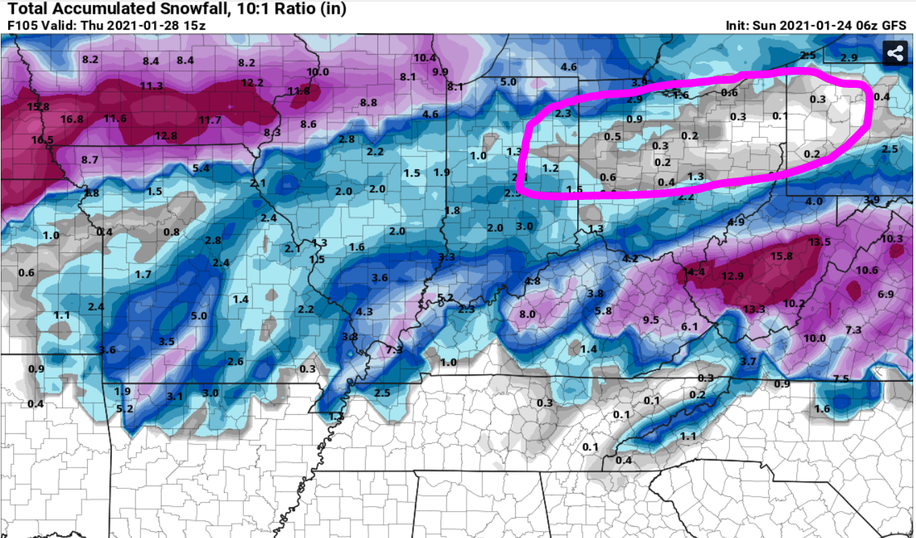
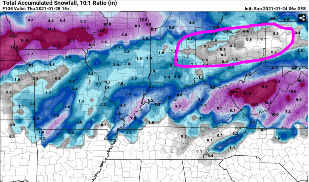
The typical warm tongue that usually slides right up the Scioto valley close to Columbus is pretty clear on the snowfall maps. I'm weary of a warmer solution coming to fruition.
-
If only is right. I just don't buy it. There is some dry air likely at precip onset and there will certainly be a surge of warm air. Everything is probably still on the table. It would be comforting to see the gfs come around however.
-
18z euro showing something we don't see around here often. I have my doubts per usual. These love to get swept out from under us in the last 48 hours.
-
Given how conservative ILN usually is with snow this is notable.
-
Yeah for sure. I think the thump is good regardless. Now whether or nor we are cold enough for the ULL stuff will be the difference between 2-4 inches and a major storm.
-
I'm trying to be very cautious with this. We've seen these trend north and go warm within 48 hours a million times.
-
Ugh I'm gonna need these to stop inching north
-
Everything is just a tad too for north for me to get something big. I'll a 2"-4" thump any day though.
-
You know the past 5 winters have sucked when I see one bad run and feel like jumping ship on the storm. EPS is all dry for Central OH
-
Yeah our climo sure doesn't do us any favors. On 1/19/19 I changed over to snow pretty early being that I'm up in Union county. I forgot about the 2/20/19 big thump event that put around 4-5" in the city and over 6" in parts of Madison county, but was only a WWA. Central Ohio certainly struggles with the tougher warning criteria that almost everyone in the Lakes, Plains, and Northeast has, but with crappy climo.
-
Yeah for sure. 1/19/19 looked like an easy 8"-12" north of I-70. I got 6" with 1.4" of liquid that day. What could've been.... I'm pretty sure the last warning before that verified would've been 3/1/2015 with a WSW upgrade during the storm, and the 2/1/19 clipper got close to warning criteria with high ratios. However, he last true watch turned warning that met criteria was 2/21/15. That's 2,166 days. ugh...
-
I put this out on Sunday. Make it 738 days.
-
Can't wait for this threat to trend into 20 mins of snow then rain
-

-
Hot damn just saw the gfs...
-
Suppress it to the gulf!
-
Although they never made it within 168 hours, the last 2 or 3 signals ended up getting suppressed way south. I think that's my only glimmer of hope at this point.
-
Yeah that's how it goes. We can get lucky from time to time and stay all snow but we're typically limited to front end thumps or backside snow.
-
I've got the gut feeling that I-70 area and well to the north will be mostly rain. It's still nice to see this type of setup with ample cold air for once. Feels like the classic winter storms we all love.
-
I-70 crowd is punching air. Long ways to go.
-
The block wants to shred anything and everything. Euro/ukie have the energy survive while the eps even pushes precip up into the most of the sub for wave 2. This thing isn’t far off.
-
Winter 2020/2021 Short Range Discussion
Gino27 replied to Chicago Storm's topic in Lakes/Ohio Valley
Chicago folk getting slammed right now? Some of my friends from up there saying they've got close to 2"! -
Just burn it all down and torch it to oblivion. This might be the earliest I've found myself sick of winter.
-
Absolutely ripped here about 30 mins ago. Quick half inch and still coming down. I’m not sure I’ve seen flakes that big in a while.
-
Might be a big day down in Dixie. We could get some thunder if enough instability is pulled up into the OHV.