Prospero
-
Posts
1,168 -
Joined
-
Last visited
Content Type
Profiles
Blogs
Forums
American Weather
Media Demo
Store
Gallery
Everything posted by Prospero
-
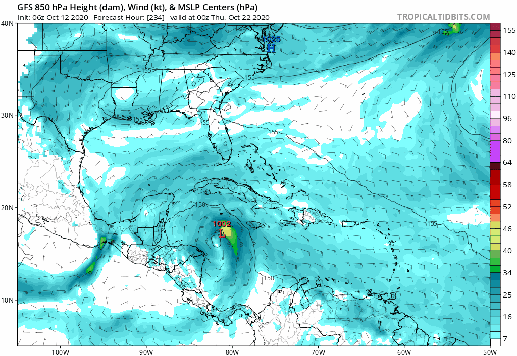
Just going on the elongated minimal pressure obs from recon and their veer to the center point of that CDO feature. At any rate, it's looking like Zeta is going to run out of ocean surface before it can go bonkers, which is a good thing. Landfall south of Delta and a lot weaker, which means more time over the Yucatan before moving back over warm waters? (May not be adding anything to a met discussion, but there are a lot of us who check out this forum and love the technical met secret codes who are here for the sake of being with like minds.) TS conditions in Cancun, but hopefully not too much more. Still a storm to watch for we who are totally obsessed...

-
Where can I find a path history to see any zigs and zags. My storm follower amateur eyes have thought I've seen some, but so far do not have path history in my small bucket of visual tools to look at.
-
-
Delta passed over quickly. If it's eye and structure held together the end game would have been much worse. Granted almost a month ago, the Gulf has cooled a bit.
-
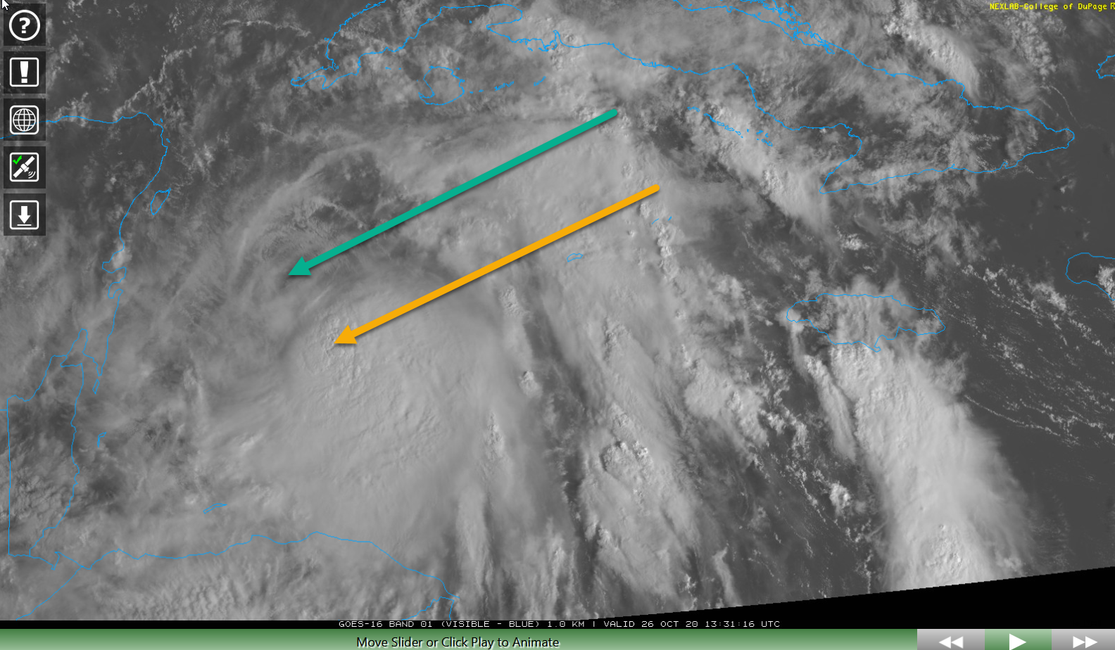
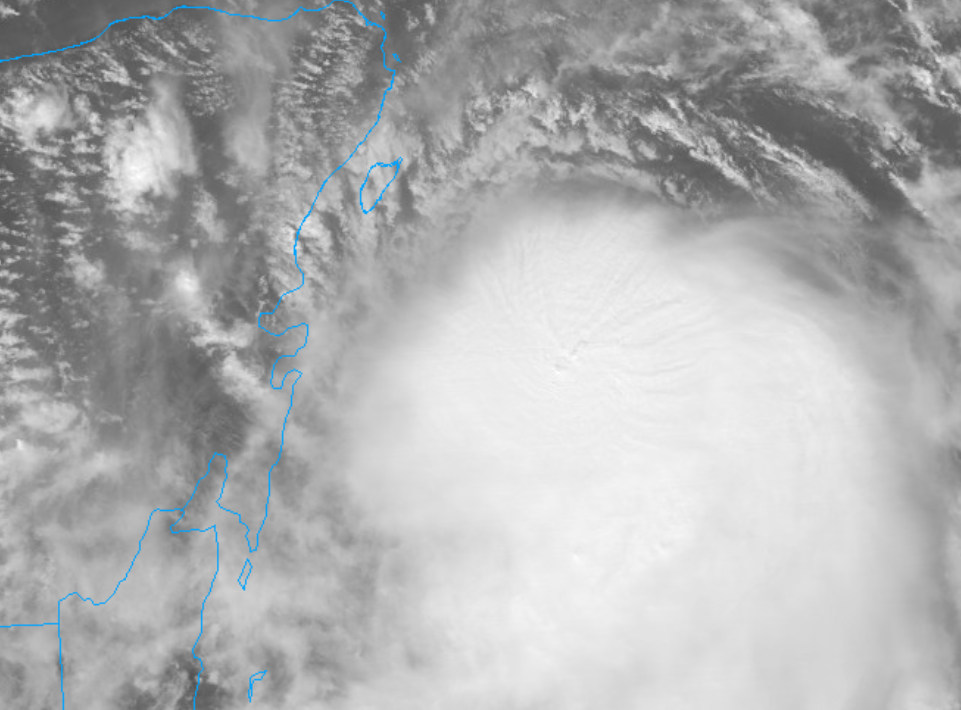
Some nice patterns coming from the center of the convection:
-
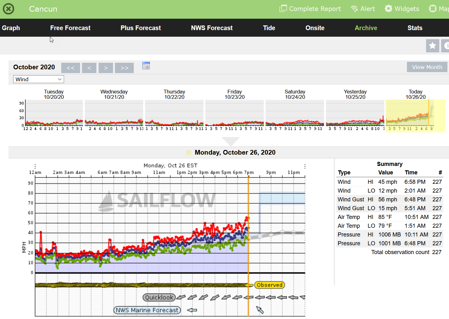
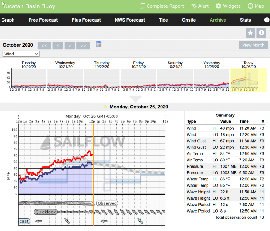
No radar, but we do have a few anemometers to watch. Kind of makes me want to fly into Cancun and rent a car to drive around in the approaching storm...
-
Too bad no radar to see...
-
So the actual center of Zeta is where the green arrow points, not the yellow arrow?

-
It is certainly not the first time Tampa Bay has been in a long-rage future model this year. In fact, I've lost count how many times. I suspect if this develops it will land in western LA. Still something to watch. It's been a warm muggy day here today. October has been very warm this year.
-
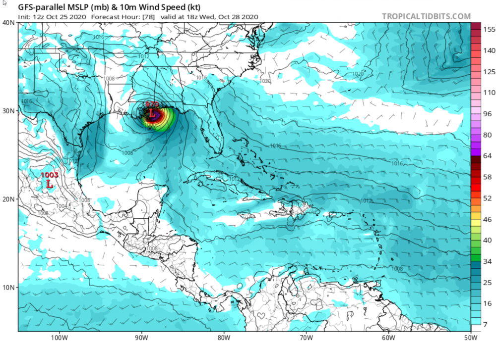
The GFS parallel has it at 970 in the same spot.
-
Yea, not too long ago on this forum that was considered over. But this is 2020. Things do shift quicker in the Fall, might land more East...whatever it is when it lands.
-
Seriously? Not that we are jealous this year in the Tampa Bay area, but hey come on... We always need the rain this time of year and it is typically late season TS rain that gives us the break to not be dry as a bone entering the winter. If we don't get some some strong winds we are setting up for a big problem next year, or the next, when the winds do blow. Like the wildfires out west where a few years with no fires sets up for a bad year. That does happen in Florida as well, especially up I-75 and I-4. I do not think Alabama is lacking rain this year...
-
"Watch Gulf of Mexico hurricanes safely from your beachfront balconies in luxury vacation condos from Clearwater Beach to Sanibel Island!" Not far from the truth this year...
-
Not holding my breath, but maybe am still holding my breath clinging onto something vague that may or may not happen. Sitting outside tonight feels like Fall here in the Tampa Bay area, but really by now we usually have a strong arctic front come through that chills us down for the year. Not yet. Sad to see 2020 season close, being such a storm voyeur, but very happy we have been spared. But maybe a yet to be Tropical Storm with some respectable winds, significant late season rain, and mild noticeable storm surge around here just to be a part of this 2020 season? I'm OK with that.

-
It could have been better for Louisiana, but could have been worse for west central Florida. It's not Thanksgiving yet, so still not 100% confident. But it is looking like we were spared another year so far. But, this is the year 2020...
-
Might be one of the most interesting years I remember. Started early, almost always a storm to follow, plenty of potential Cat 5s, a stream of hype and disappointment, yet entertaining and still something to watch even tonight. Some years are total duds.
-
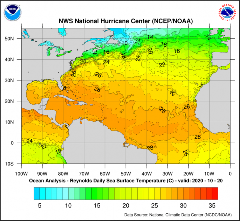
Still some warm water...
-
2020 just keeps on going...
-
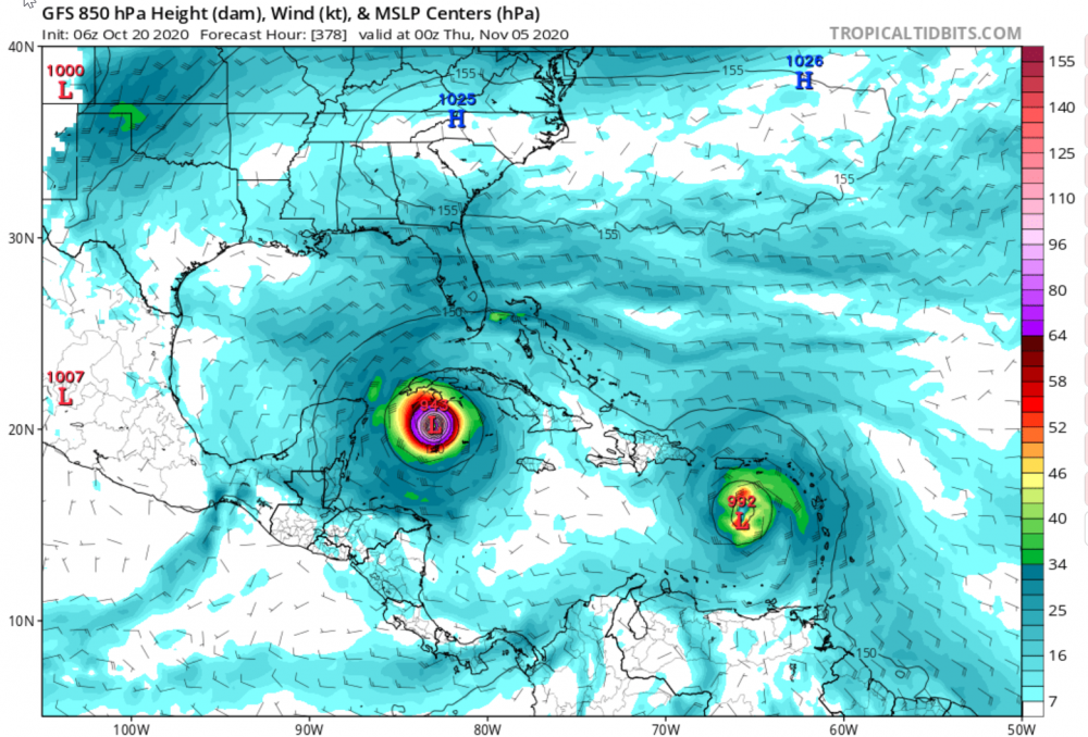
We've had TS winds at moments and gusts several times here at 50+ mph with some of the storms, a few mild storm surges, and beautiful roller waves several times from several Gulf storms. We were in five-day cones a few times, but never a warning. 18z GFS has the latest storm going over Cuba and out to sea. But each day brings new models. Funny how the models always have perfect eyes. That is the problem with the models, the computers don't know how to throw a fly into the mix. Especially in 2020 with perfect eyes being so rare with random flies always messing them up.
-
Thanks TradeWinds, Florida neighbor. I've been involved in internet forums since the 90's, alt this and alt that. I've been checked so many times I can't count. But manners are important, and timing is everything. When the discussions are barely active there is room for more personal input, like where to go for Sushi, etc., or occasional far-out ideas. But I do get excited when things are active and have posted inappropriately after a few beers when people are scrambling for their lives as a hurricane is approaching. I am not trying to be on ignore lists, and it hurts my "feeling" (as a good friend used to joke with me), but learning the expectations of any social environment is just part of growing up and belonging to a group. If I am ignored, it is my own fault. Someone making a point of it publicly may or may not be seeking attention, it may be directed totally at me to "behave" which I get. My skin is thick, by experience! When I get to the point of not learning or taking criticism, then I am trouble. Second part, in Tampa Bay we've been in so many models with powerful storms predicted several days out that we are getting numb. That is foolish, as this is 2020 and only mid-October. We do know we may be preparing for a storm even up to Thanksgiving. But it is weird we have not been in an actual Tropical Storm or Hurricane warning this year. That might even make it more likely we could get slammed at the last minute to fully complete 2020. (Ooooops crazy talk again!)
-
Still hoping west central Florida skips the storms, but it does seem unfair we have not been in any kind of warning in 2020 and that is just embarrassing. For those who have not added me to their ignore list, Tampa Bay is more in the focus on the 12Z model:

-
I do try to contribute quality more than raise an eyebrow now and then speaking what is truly on my mind. But hey, Truth (or possible Truth) is and has always been a scary and dangerous concept. We could go back hundreds of years and see examples of "conspiracy theories" being denied that were true and angered people only to learn in history how true they turned out to be. Even the weather modification experiments in the 60s were conspiracy theories until they were acknowledged. I'll try to be more conservative. I love this forum and hope I do not get banned altogether. GOL (ghost of leroy) is still here, so maybe I'll be OK even though on an ever growing list of ignores...
-
Hmmm, 13 days out. Wonder how our toilet paper supply is...

-
Not yet. I just checked again. Same thing with Laura and I'm not sure how long before it showed up. News reports typically say "100 mph" winds at landfall at Creole with Delta that might be based on reports from those who have the data license to see what Cameron documented. So my guess is a sustained 100 mph wind with gusts maybe 125 or 130. Seems like it should be more and maybe it will be. Cameron finally shared 92 mph hour sustained and 117 mph gust with Laura. Lake Charles Airport was showing 98 mph sustained and 132 mph gust when it went off at 1:53 am on August 27th with Laura. Delta hit the same airport with 59 mph sustained and a gust of 94 mph. Still powerful and lot of power out again. What a nightmare for people around there. I will say the "Frances/Jeanne" double whammy around here was nothing compared to "Laura/Delta". And it still was a long recovery for many. Glad we on the central Gulf coast of Florida have been so very lucky this year.
-
https://en.wikipedia.org/wiki/Hurricane_Delta ...The twenty-sixth tropical cyclone, twenty-fifth named storm, ninth hurricane, and third major hurricane of the very active 2020 Atlantic hurricane season, Delta formed from a tropical wave which was first monitored by the National Hurricane Center (NHC) on October 1. Moving westward, the wave began to quickly organize and due to its imminent threat to land, it was designated Potential Tropical Cyclone Twenty-Six late on October 4. The next day, the system sufficiently organized and was designated as Tropical Depression Twenty-Six, and soon thereafter, Tropical Storm Delta. Extremely rapid intensification ensued throughout October 5 into October 6, with Delta becoming a Category 4 hurricane within 28 hours of attaining tropical storm status; its pressure bottomed out at 954 mb before its winds peaked at 145 mph. The rate of intensification was the fastest in the Atlantic basin since Hurricane Wilma in 2005. After peaking in intensity however, an unexpected slight increase in wind shear greatly disrupted the small core of Delta and the storm quickly weakened before making landfall in Puerto Morelos, Mexico, as a high-end Category 2 hurricane. It weakened some more over land before emerging into the Gulf of Mexico, where it was downgraded to a Category 1 hurricane. After that, it began to restrengthen, regaining Category 3 status late on October 8. It then turned northward and reached a secondary peak intensity of 120 mph and its lowest pressure of 953 mb early on October 9. Delta then began to turn more north-northeastward into an area of cooler waters, higher wind shear, and dry air, causing it to weaken back to Category 2 status. Delta then made landfall at 23:00 UTC near Creole, Louisiana with winds of 100 mph (155 km/h) and a pressure of 970 mb (28.64 inHg). Delta began to weaken more rapidly after landfall, becoming a tropical depression.