Prospero
-
Posts
1,168 -
Joined
-
Last visited
Content Type
Profiles
Blogs
Forums
American Weather
Media Demo
Store
Gallery
Everything posted by Prospero
-
For the first time this year, I am actually starting to get a gut feeling like we might get hit harder than we've been expecting here in Tampa Bay. Not a lot of time to get ready, and no warnings up yet. Hopefully I am wrong.
-
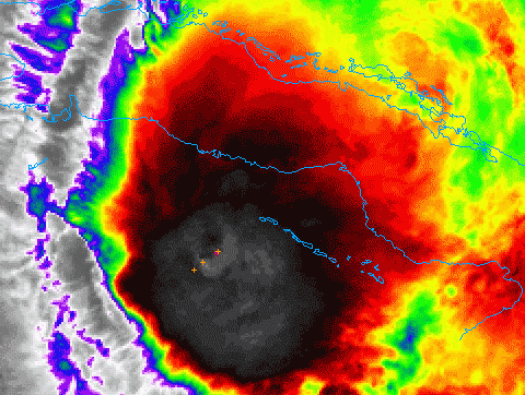
Nice convection burst going on now. I don't know if it is over the center though.
-
Xi on Xmas? LOL
-
Zeta > Eta > Theta > Iota?

-
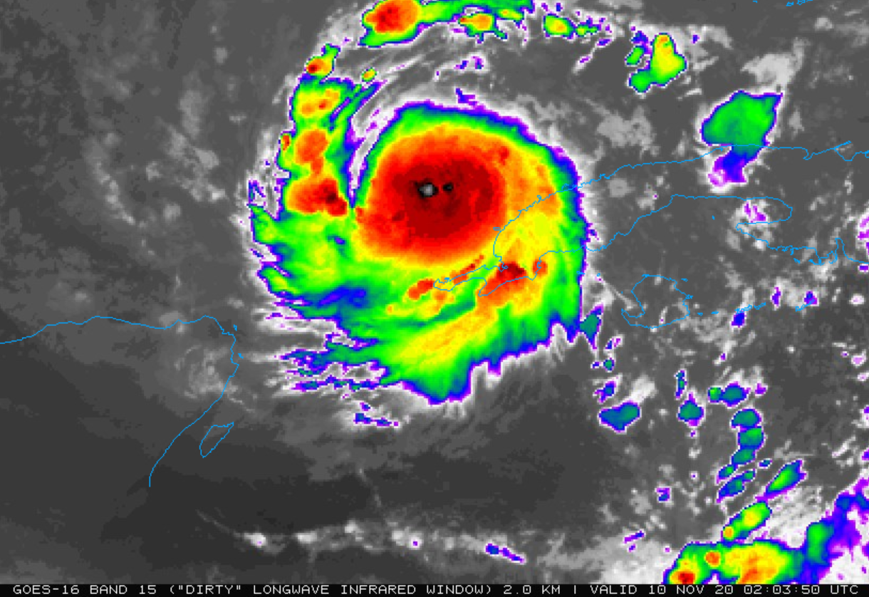
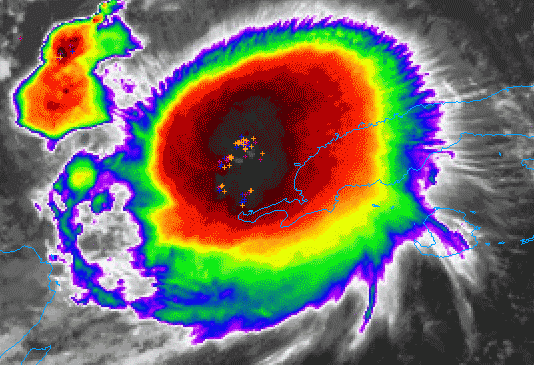
Looks healthy on wake up this morning: 08:21:50Z 11/10/20 to 10:01:50Z 11/10/20
-
To keep the 2020 season theme going even into mid-November... Is that an eye I see??! EDIT: Going to bed (up at 4:00 am), thought Eta was about done during dinner, now it is looking good again. What will the morning bring?? Where is it going to go???

-
Well, being 2020, we may be here tomorrow night commenting on how amazing it became in 24 hours... Landfall as a Cat (?) in west LA?
-
We had two squalls come through today here in Gulfport (Tampa Bay area) with decent winds (gusts in the 30s) and sideways rain. Winds were stronger yesterday (gusts in the 40s) though. I am still very interested in Eta, just one of the busiest work schedules I have had in months. Hard to enjoy a storm when you cannot watch it obsessively. UGH
-
Does look farther north than expected to me. Edit: I can't seem to find a radar right now.
-
That's what we are keeping in the back of our minds in my home. Hoping Eta does not fire up in the Gulf like it did before hitting the Mosquito Coast. I doubt that will happen, but a TS could be visiting.
-
Tampa Bay/Gulfport: Gust to 39 mph at the Sunshine Skyway Bridge fishing pier, 41 mph at Surfside Condos on Clearwater Beach. We've had several gusts around 33 mph here in Gulfport. It's been windy for well over 24 hours. No measurable rain to speak of, but we are quite a bit north right now. We do expect some later tonight as there is a band on the radar that could make it here. So far it's not the strongest storm of the year for us, but watching closely in case it does strengthen and turn back to the Gulf Coast in a few days. It does have that "feel" that we all know so well in tropical system areas.
-
Maybe not the worst week. For November, you will enjoy a very warm week with tropical winds from the south. You may see some rain, but for the most part you will see a lot of sunshine. Orlando should be too far east to get the big rain, but the tropical breeze may be here all week. You'll see clouds moving quickly over and get to experience a "tropical" system. Even if Eta becomes a hurricane, it will not be a Charlie that races across the state impacting Orlando. Enjoy your visit! You may have picked the BEST week to visit central Florida. Tampa Bay, maybe not as much. LOL
-
It's been a while. Nestor was the biggest impact we've had since Hurricane Irma. https://beachresortcondos.com/Tropical-Storm-Nestor.html
-
Did the ghost put almost everybody to sleep yesterday about Eta?
-
I have the bruises to prove it! LOL Top of early morning hurricane shopping list: beer more beer coffee beer D batteries beer
-
Guacamole central! All we have is acorns falling! Sats look solid.
-
Of course, this is Eta. The storm that has surprised us all so late in the season. Will it miss us in Tampa Bay, then hit Cat 3 and hit LA again? That would be par for the season.
-
Strange, when Eta was aiming at the Mosquito Coast, there was some high-end met discussions going on here. Now that Eta is aiming at Florida, it's pretty slow. Granted I know, big news day, but Eta is big for us in the United States dangling peninsula.
-
I was just outside enjoying a beer and a gust came up that almost knocked over one of our porch umbrellas that has over 100 lb of blocks on its base. That has not happened since we put it up in July with all of our strong afternoon thunderstorms that we get. And we are all the way up in the Tampa Bay area. The umbrella is now down, tied up, and put away for the next week or so. Doing more tonight that I planned on for the morning already. We have a yard of projectiles and objects that are not TS wind friendly. (My wife who was in Andrew nags at me about what "could" happen if we get a strong storm. They were not able to get out of their destroyed second floor condo due to landscaping gravel that had been picked up and piled up in front their door overnight.)
-
We are planning a shopping list for Thanksgiving and adding in late season hurricane supplies, like D batteries and filling up the gas tanks. Wind chimes, bird feeders, potted plants, yard decorations are being secured early tomorrow. Hope I am not out in the rain doing it!
-
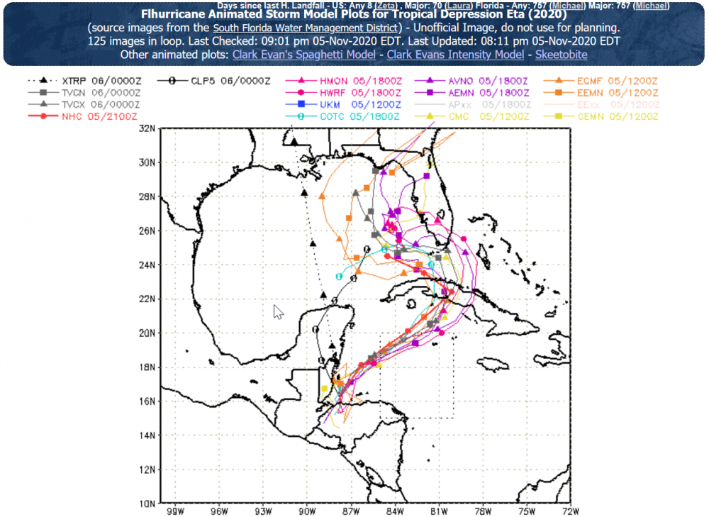
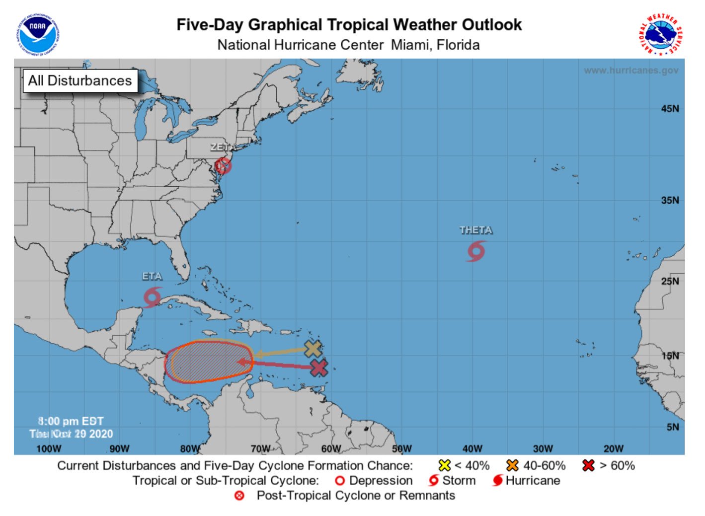
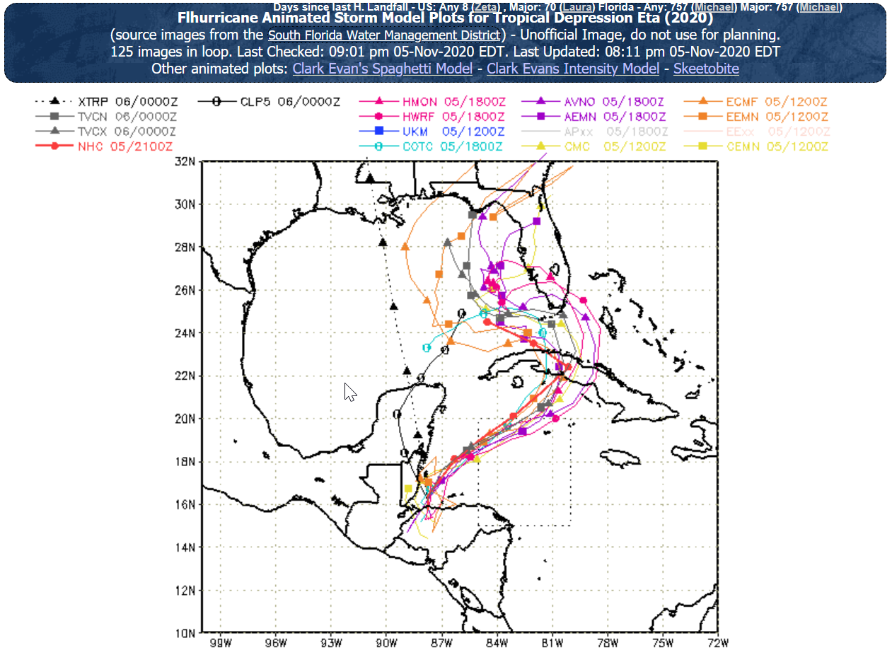
DISCUSSION AND OUTLOOK ---------------------- At 700 PM EST (0000 UTC), the center of Tropical Storm Eta was located near latitude 20.4 North, longitude 80.2 West. Eta has recently jogged toward the east, but is expected to resume a motion toward the northeast near 14 mph (22 km/h) tonight. A turn toward the north and northwest at a slower forward speed is expected on Sunday and Sunday night, followed by a westward motion on Monday. On the forecast track, the center of Eta will cross central Cuba tonight, approach south Florida and the Florida Keys on Sunday, pass near or over south Florida and the Florida Keys Sunday night and Monday and be over the southeastern Gulf of Mexico on Tuesday. Data from a NOAA Hurricane Hunter aircraft indicate that the maximum sustained winds have increased to near 65 mph (100 km/h) with higher gusts. Some strengthening is possible through Sunday night, and Eta could be near hurricane strength as it approaches Florida. Tropical-storm-force winds extend outward up to 105 miles (165 km) from the center. The estimated minimum central pressure is 991 mb (29.26 inches) based on NOAA dropsonde data. OK, here we go.
-
I'm already looking at the SailFlow maps. Been breezy here all day in Gulfport, Florida. If this develops at all in the Gulf we might be hanging onto our hats, and scrambling to secure our homes. One thing with this pass of Eta, we have good radar, hundreds of personal weather stations, and a ton of live web cams.

-
Entire season that started early, obsessed with every storm (as usual), and having taken some steps to prepare for storms I cannot now remember in 2020, we are looking at rain and winds to maybe start tomorrow. Prepared? Hardly. I am deep in a huge tight deadline project where I am learning a new programming language as I go. Perfect. UGH In the past 18 years in Florida I remember hurricane's Charlie, Frances, Jeane, Hermine, and of course the doozy Irma. Tropical storms too many to count, but Debbie brought the highest storm surge and over 16 inches of rain that was a disaster in itself. Eta spinning off our coast for a couple days can outdo Debbie, and if it does become a hurricane most of us around here are totally not prepared. Wish I was not so busy making a living this week!
-
Storm roulette! "Spin the wheel, where she stops, nobody knows!"
-
Models are beginning to tighten up. Exciting, yet not great news for Florida. Models have been better this year than any year I remember. My position for our home and Tampa Bay area is always, "Be as strong as possible without power going out, loss of life, and unreasonable cleanup expense."