Prospero
-
Posts
1,168 -
Joined
-
Last visited
Content Type
Profiles
Blogs
Forums
American Weather
Media Demo
Store
Gallery
Everything posted by Prospero
-
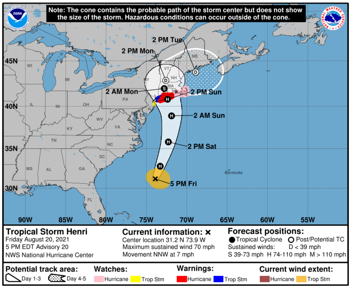
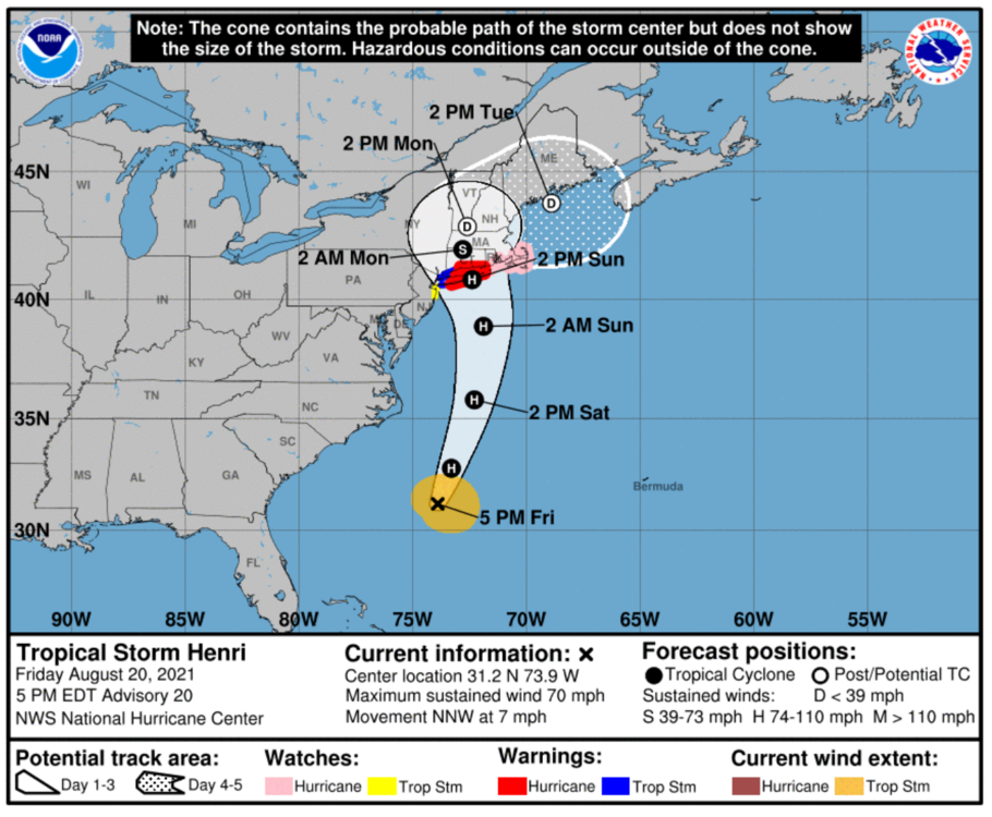
So I text my brother this morning In Vermont. "How is Henri up there?" He responds, "Henri is a p****!" and sends this selfie video: part0.mp4 Of course he is either on top of Mt Mansfield or the Camel Hump which he climbs almost daily. LOL EDIT: I added asterisks in his term because neither he or I would want to be offensive. The term he used translates to, "very wimpy." But anyone who did not grow up in the 70's might take it in a different meaning today which does not apply to what he said. I get it, thus the edit. We older people need to be aware of what we say in innocence that is not appropriate anymore. I may even remove the only letter left in his term as it might be too much. Let me know.
-
We were out almost 3 weeks after Irma. Funny, for us down here in Florida it was the not having A/C that was killing us. Our food in the fridge was gone in 2 or 3 days, we had battery fans and lights, and ate canned food or out anywhere that was open (A/C too). I wonder up north what is the worst issue of no power.
-
I remember that Josh was "missing" during some storm last year, then popped up with tales to tell later. I could look, but actually still working right now...
-
Oh yes, I see it is HOT right now. I didn't even think about a New England sub-forum during a Tropical Storm. LOL Look at all those names I've never seen! Might have to jump in just for fun. Or not, I am not seeking for more people to block my posts.
-

2021 Atlantic Hurricane season
Prospero replied to StormchaserChuck!'s topic in Tropical Headquarters
The Low off the Tampa Bay coast has my attention. Texas might be busy. Maybe Josh should rent a place for a month or so in the Yucatan and set up some web cams? -
I'm here. But not a Tampa Bay storm just watching mostly. But yea, where are all the "Sandy" people who we are used to seeing post?? Weather Channel is all over it, so it is in public domain getting attention.
-
2021 North Atlantic hurricane forecast contest
Prospero replied to Roger Smith's topic in Tropical Headquarters
LOL! I knew I went low on named storms. A few surprised me; Anna, Bill, Claudette, and Danny. Elsa, Fred, and Grace were maybe in my numbers. Henri is another surprise. So for me to win, almost every named storm will be hurricane and mostly a major. Figuring late September and October start, I was likely way off. August did fire up a bit. Good thing I am not a met with people depending on my predictions! -
Was it Josh who last year was in a rental car down there sharing videos and banging up the car?
-
Need A Place to Get your Hurricane Information?
Prospero replied to Texas Weather Center's topic in Tropical Headquarters
Good luck with the site. Hopefully we are not all going there because of a major in TX this year.- 1 reply
-
- 1
-

-
- hurricane data
- hurricane
- (and 1 more)
-
Is anybody there to take photos in Mexico? Or are you talking about visible sats?
-
Looks like there is a window of time before landfall. Convection looks strong. I'm ready backwards on posts to catch up...
-
WTF Guess I have been away too long.
-
Yes. Laura had an awesome eye during the 24 hours leading up to landfall. It did. Zeta and Eta had more impressive perfect eyes as it approached the Yucatan.
-
Best eyes of the year last year were the ones that pounded the Yucatan coast. Couple out in the Atlantic that we watched as well. But the ones that came in late season were very impressive and were devastating to that area.
-
Sorry for not paying attention, having to do day job work catching up. Fred screwed up my schedule. But did Grace ever get a real visible eye?? (I'd look now and then on sats.) Will try to back track over posts later tonight...
-
That's not good. I guess it could have been worse, but still not good.
-
We had one band here in Pinellas County come through today after passing by for many hours offshore; maybe 15 or 20 minutes of sideways rain and winds around 20 mph, but nothing big except the visuals that creates like flooded parking lots and swaying palms that seemed to possibly be exaggerating a little.. Our temperatures around here have been less than the ocean the past two days, so it appears the band came over land and lost its fuel and faded out quickly.
-
I'd pay to have that job. Who needs food and bills paid anyway.
-
Can anyone explain this? I suspect a small tornado.
-
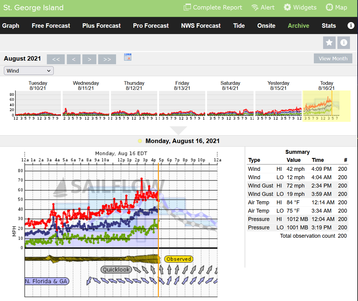
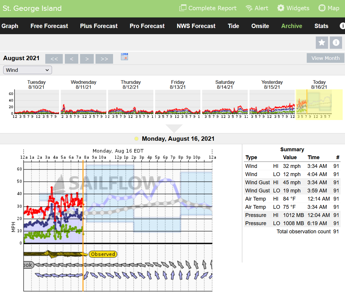
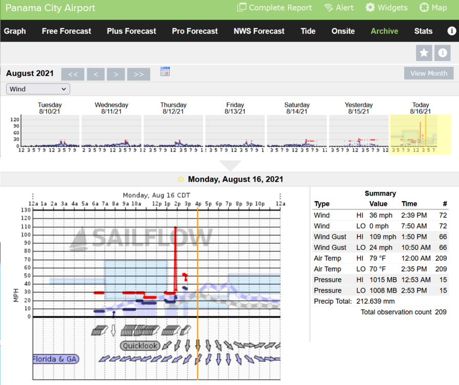
What a fun day here (reading on my iPhone when I could today). Had to actually do work today. (Hate it when that has to happen, especially during a Gulf storm.) So exciting! Almost a hurricane! Fred!!? Really?? 72 mph gust at St George Island, so far the best I've seen from the "new" Fred.

-
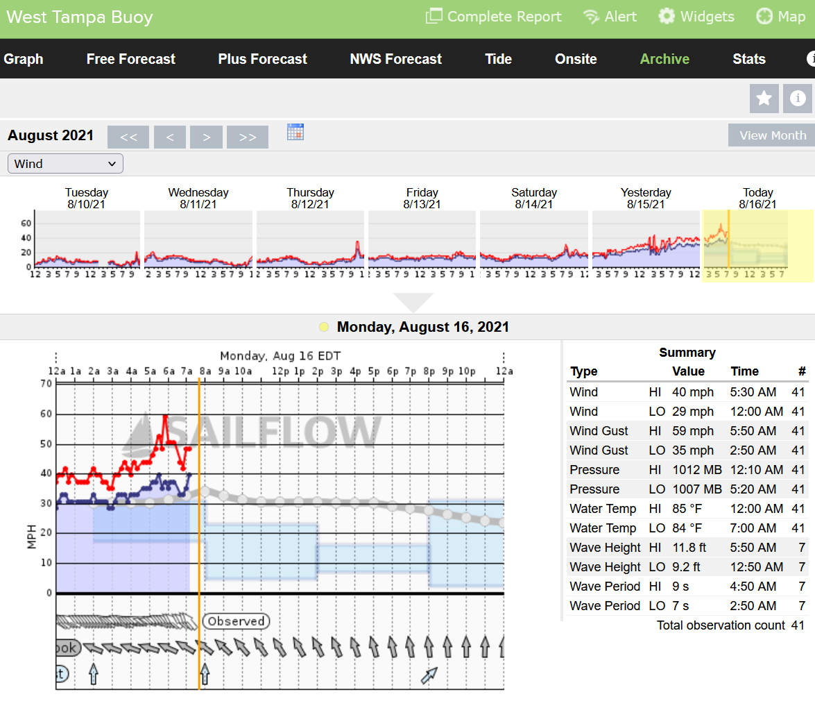
So far the strongest winds seem to be at the West Tampa Buoy which is the convection right now. Note the 11.8 ft waves.

-
Was just checking the winds up there. Looks like you might take the brunt of the convection.

-
Fact: The Haiti earthquake was going to happen no matter what at some point. Earthquakes will always happen as the Earth's crust moves. Fact: Hurricanes happen no matter what. Fact: There will always be coincidences of all kinds just by mathematical chance. Coincidences do happen. Fact: No scientific knowledge is ever complete, and it is a flaw in thinking to assume anything else. We learn new things and discoveries are made continually. What we once knew to be a fact, often turns out to be false. Can a hurricane have influence on the timing of an earthquake? Let's ask again in 100 years.
-
I wouldn't have believed it if I couldn't see it on the visible! LOL Oh well, I have to go to bed. My Sunday fun is over, will be up at 4 and see what is happening.
-
Can see it on visible a little. SW, wow. https://weather.cod.edu/satrad/?parms=local-Orlando-truecolor-12-1-100-1&checked=latlon-map&colorbar=undefined