Prospero
-
Posts
1,164 -
Joined
-
Last visited
Content Type
Profiles
Blogs
Forums
American Weather
Media Demo
Store
Gallery
Everything posted by Prospero
-
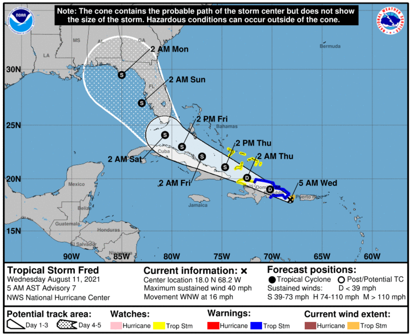
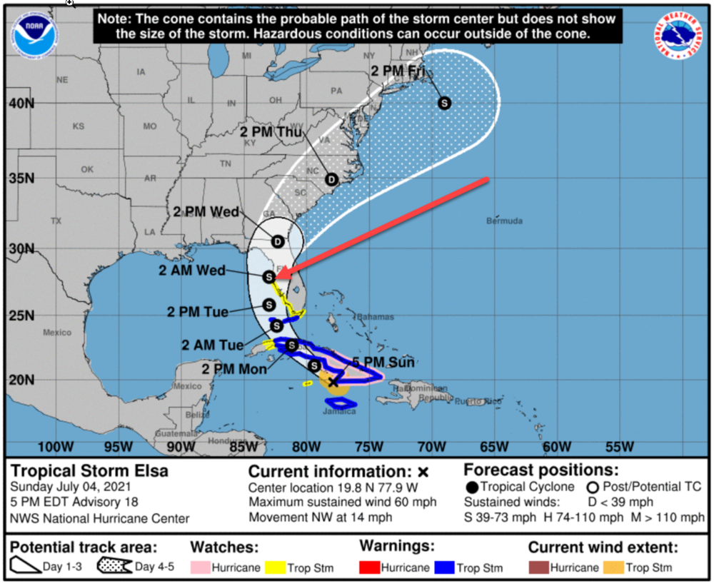
Starting to figure some preparations into my schedule. Maybe even a little shopping today. Reminds me a bit of Elsa, at least in relation to Tampa Bay (July 4 at 5PM): Elsa was a "Hurricane" when it passed very near us on July 6 yet it was not much of a storm here. Seriously, a substantial Tropical Storm in the same place would be much more of a concern, and Fred might be setting up for that if it survives the mountains. (Just scanned the Elsa forum and it is funny how similar all these storms forums become! LOL)

-
Power is out here due to lightning, best lightning storm all season. So we have a taste of what can happen during tropical systems. Half hour and already stuffy and warm inside! Good thing for tablets and smart phones can still follow discussions. Lol Duke Energy says back on by 12:30 am.
-
MIke Clay on BayNews9 said there are three centers right now, still a wave.
-
Did they fly into the storm today? Thought it was mentioned.
-
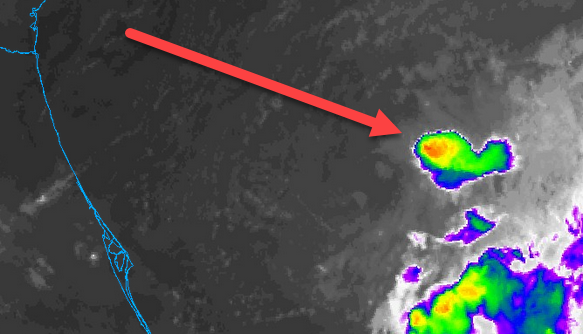
Best of the year even early in its life. Trying to upload a clip but keep getting this: Sorry, an unknown server error occurred when uploading this file. (Error code: -200) So here is a link: http://007computer.com/storms/CODNEXLAB-GOES-East-meso-meso1-truecolor-17-45Z-20210810_map_-87-4n-6-100c.gif
-
Thanks! Several models have something near or over us around the 15th. We'll be watching of course, and the 15th is a Sunday so better for any preparations if needed.
-
This year takes the cake on that one, even ragged presentation. But 2019 had its share too. "I think I see an eye" has been almost a joke around here for quite a while.
-
I remember well. Good thing they typically didn't develop perfect eyes and reach what some of us expected on those paths. There were some good conditions at times.
-
Central West coast of Florida could use a good solid rain event and even some moderate TS winds to blow out a few cobwebs and stir up the ocean a bit to help get rid of the red tide. Time to watch and pay attention for us. What we don't need is a Hurricane on any level...
-
Seems to me the past few years more often than not storms survive even after going over the highest terrain. Might be my memory only remembering ones that do survive, but I do remember watching many survive where everyone thought they'd be destroyed. And then some appear to get angry and really fire up...
-
Been waking up and watching. We need the rain in Gulfport, FL. This time of year we take all we can get, because it starts to really dry up up soon.
-

2021 Atlantic Hurricane season
Prospero replied to StormchaserChuck!'s topic in Tropical Headquarters
At this point I would be very happy watching intense storms way out in the Atlantic that curve away from the US. Give me a perfect eye major to watch spin over the ocean and I am good. Let them all stay out there. We'll still enjoy the beautiful rolling waves as they hit our shores from far away. -
2021 Atlantic Hurricane season
Prospero replied to StormchaserChuck!'s topic in Tropical Headquarters
We are entering new territory as far as weather. Everything we know and have learned so far might be wrong for now on. Good for some places, bad for others. Yea, I know, let me have it. I'll have another beer and go to sleep for another break before Hell may or may not break loose... -
2021 Atlantic Hurricane season
Prospero replied to StormchaserChuck!'s topic in Tropical Headquarters
I will look into it. Thanks!! I've looked at generators for many years. But one thing that held me back was the age of the gasoline. I have a weed-eater I bought and put gas in and also a gas container that has been sitting for almost tens years. I have great landscapers who do what I ask, and the weed-eater only got used one time. I remember the manual saying to keep the gas fresh and never leave old gas in a gas container. So having a generator that might get used every few years had me concerned. Maybe I have over thought it, but definitely a thought. Yet a $150 device I can hook up to my car and a cheap small fridge would keep my wife's insulin cool and maybe a six pack as well. Plus some cheese and half-n-half. Even so, after a few days of no power we are seeking an air-conditioned room somewhere. But seriously, sleeping with a cpap, I'd hook up and get some sleep for a few hours in my car if I need to even with just a night outage after a wild thunderstorm! Making sure carbon-monoxide is not a danger of course. -
2021 Atlantic Hurricane season
Prospero replied to StormchaserChuck!'s topic in Tropical Headquarters
I just took step ONE in preparing for the season: I cleaned out the door in our freezer and one shelf (filled a kitchen trash can). With Irma we lost everything in the freezer and fridge and when the power came back two weeks later our old refrigerator was sparkling clean like brand new. We had plenty of time to clean it thoroughly. It was the last time we thoroughly cleaned it (2017). I tossed everything today from 2018 and 2019. No matter what it was, if we haven't thawed and eaten it by now, we never will. I did NOT mention what I did to my wife, of course, but she'll never miss anything of it at all. "What happened to the frozen Salmon we bought from Sam's Club a few years ago?" "Hmm baby, I don't know. Maybe we ate it?" What is important is having space to stock ice or freeze blue-ice packs in the last buying moments as a storm approaches when it is still available for my beer and our half-n-half for coffee. People say we need a generator. Good idea. But we can last two days without power. It's when it is like a week or so it gets really bad. During Irma we had neighbors who had lights and kept their food safe. But by the third night or so our neighborhood was dark and dead silent at night as they all ran out of gas. Charging our phones and laptops from our vehicles was the saving technology. And we could still hunt down and buy gas in Pinellas County after Irma, luckily. Plus it was nice to sit in our vehicles with blowing A/C when it was brutal hot in our homes and listen to music. But ice was nowhere to be found, even frozen food was sold out in any open grocery store as people were trying to use it to keep whatever they had left cool. Mostly beer I imagine. Since 2003 when I moved back to Florida I've experienced maybe a full month with no power; Hurricane Jeanne was a week, Irma two weeks, other passing storms and typical severe thunderstorms are definitely a week combined. Always a pain, but being prepared for 24 to 48 hours is easy enough and is worth while. Longer than that is getting to point of finding a place to stay until the power comes back on. "Home camping" in the heat and humidity of Florida gets very old quick. UGH -
2021 Atlantic Hurricane season
Prospero replied to StormchaserChuck!'s topic in Tropical Headquarters
I am bit more concerned with October right now... -
2021 Atlantic Hurricane season
Prospero replied to StormchaserChuck!'s topic in Tropical Headquarters
Oh boy! Something to watch! -
2021 Atlantic Hurricane season
Prospero replied to StormchaserChuck!'s topic in Tropical Headquarters
Every year I watch and watch. Even slow years. I have my doubts about this year and have since Spring. Watching, always. Low numbers, late season, and intense when it does happen. Hopefully all off the coasts fun to watch with perfect eyes and not too much stress on we who live on the coasts. Of course, that is NOT based on anything scientific at all. So possibly very wrong indeed. I'm going back to sleep as I may need it later! -
2021 Atlantic Hurricane season
Prospero replied to StormchaserChuck!'s topic in Tropical Headquarters
OK, I'll try. Zzzzzzzzzzzzzzzzzzzzzz.... -
2021 Atlantic Hurricane season
Prospero replied to StormchaserChuck!'s topic in Tropical Headquarters
Just for fun, how far do you think we'll get in August? I say Ida (EYE-duh) is in September and being an "I (eye)" storm will be the one to watch this season. So for me, Henri will be the last August storm and I am not real confident we'll get that in the next month. I may be very wrong of course. I don't even know if I want to watch a "Hurricane Sam", unless it hits Wyoming... -
2021 Atlantic Hurricane season
Prospero replied to StormchaserChuck!'s topic in Tropical Headquarters
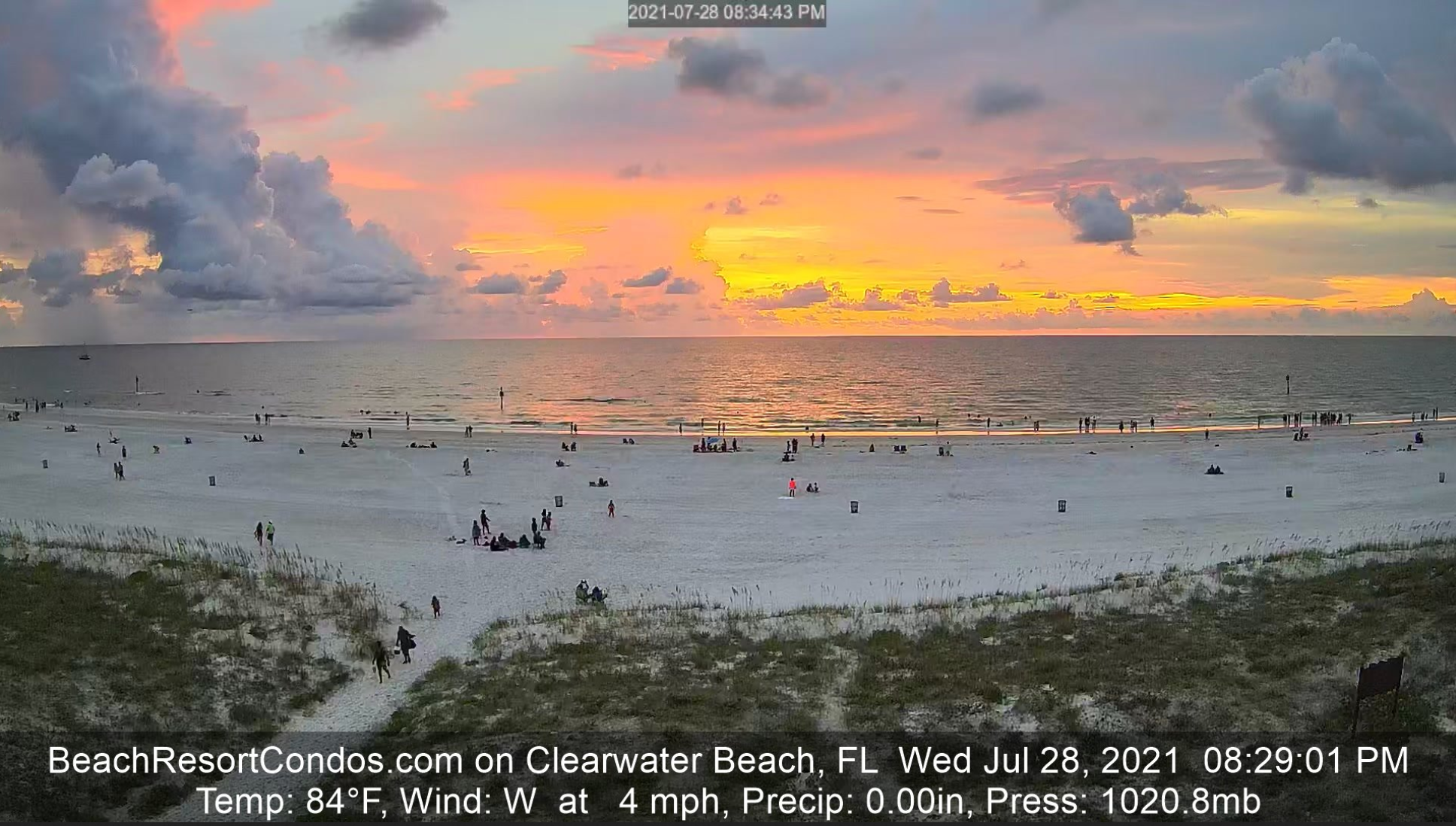
Will we see Fred in August? Will we see Teresa at all? Teresa is my mother-in-law's name. Maybe around Thanksgiving if things really pick up. LOL In the mean time, nice on Clearwater Beach for the next few weeks...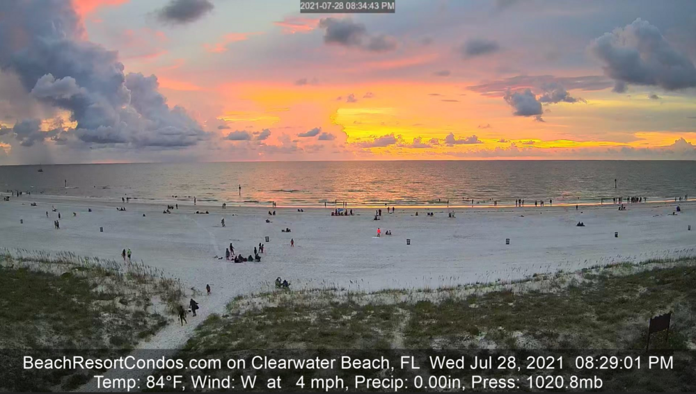
-
2021 Atlantic Hurricane season
Prospero replied to StormchaserChuck!'s topic in Tropical Headquarters
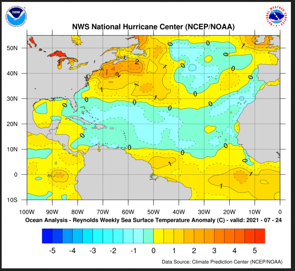
So that is the recent change, right? But are the surface temps cooler than normal?
-
2021 Atlantic Hurricane season
Prospero replied to StormchaserChuck!'s topic in Tropical Headquarters
Not that I am chomping at the bit, but I am chomping at the bit. Yea I know, so inappropriate, so irresponsible, so reckless and careless, but I can't help it. I am storm sick. Still think a very late season with few names, but strong ones that do get there. I have outdoor tickets for Dead & Company and Rolling Stones in Tampa in October which normally would be a cool quiet weather time for outdoor shows. Hoping no Tropical systems on those dates...really looking forward to both shows. -
2021 Atlantic Hurricane season
Prospero replied to StormchaserChuck!'s topic in Tropical Headquarters
Katrina was a monster 5 over the Gulf and then the eye mysteriously kept falling apart as it approached landfall. Just like all the storms off Texas last year that we all expected a perfect eye and they kept falling apart every few hours. Yea, some random dry air, other unforeseen circumstances. But Katrina is the one I first remember with a "weird acting eye" and it was a scary monster and still ended up a monster... -
2021 Atlantic Hurricane season
Prospero replied to StormchaserChuck!'s topic in Tropical Headquarters
Look a convection burst! (OK, bed time for me, I get up early as hell. But I'll look when I get up!)