Prospero
-
Posts
1,168 -
Joined
-
Last visited
Content Type
Profiles
Blogs
Forums
American Weather
Media Demo
Store
Gallery
Everything posted by Prospero
-
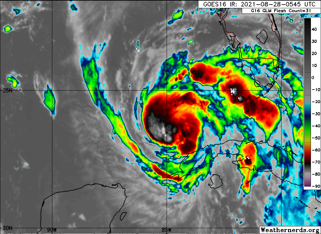
I remember Katrina where everyone kept saying as soon as it develops an eye it would strengthen even more and it kept falling apart. Only just before landfall did the eye really look good. I've watched many storms in the Gulf since then where the same discussion happens. A perfect eye is expected, should appear, and they fall apart. Yet we get perfect eyes approaching the Yucatan and out in the Atlantic. Maybe some unknown phenomena has developed in the Gulf that makes it harder for a perfect eye to manifest.
-
This discussion comes up every year I think, at least since I have been around. From what I can gather is that there is no "rule", even with the English language. Years ago the media started to move away from "he/she" based on some who, like buckeyefan1, say of a hurricane, "its a pile of parts..." Others will say a hurricane is remembered by it it's name and displays a personality to some. In fact, some will say the Earth itself is not alive, it is just parts. Whereas others say the Earth is a living entity and we are all just parts of it. I miss speaking of storms by their name suggestions and I cringe even now when I force myself to call Ida an "it". I'm in the smaller school of thought that storms are alive themselves for their brief periods on our living breathing planet.
-
All-Righta.
-
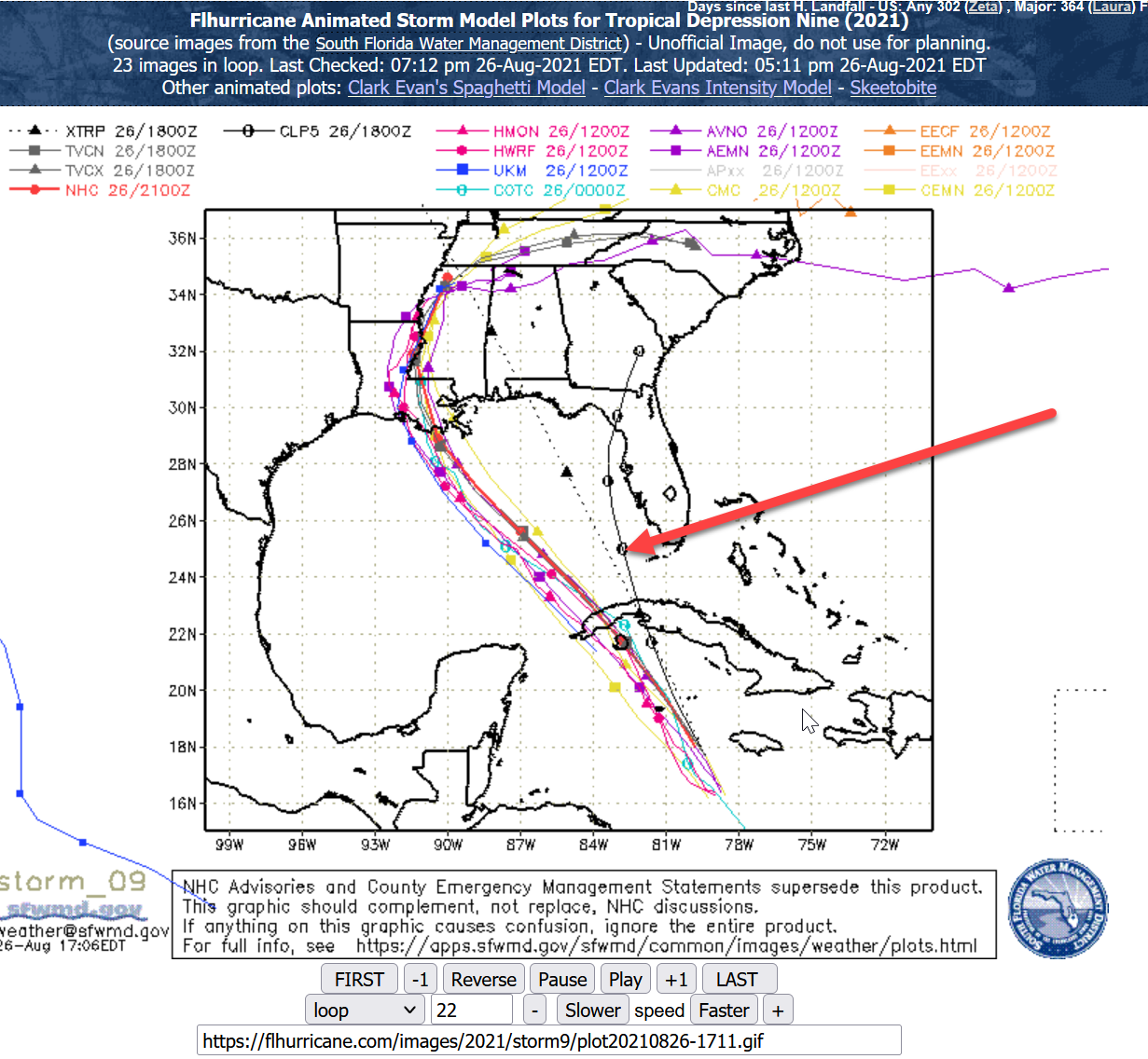
DISCUSSION AND OUTLOOK ---------------------- At 700 AM CDT (1200 UTC), the center of Hurricane Ida was located near latitude 24.4 North, longitude 85.7 West. Ida is moving toward the northwest near 16 mph (26 km/h) and this general motion should continue through late Sunday or early Monday, followed by a slower northward motion on Monday. On the forecast track, the center of Ida will move over the southeastern Gulf of Mexico today and move over the central Gulf of Mexico tonight and early Sunday. Ida is then expected to make landfall along the U.S. northern Gulf coast within the hurricane warning area on Sunday, and then move inland over portions of Louisiana or western Mississippi later on Monday. Maximum sustained winds have increased to near 85 mph (140 km/h) with higher gusts. Rapid strengthening is forecast during the next 24 to 36 hours and Ida is expected to be an extremely dangerous major hurricane when it approaches the northern Gulf coast on Sunday. Weakening is expected after Ida makes landfall. Hurricane-force winds extend outward up to 25 miles (35 km) from the center and tropical-storm-force winds extend outward up to 115 miles (185 km). The latest minimum central pressure estimated from NOAA reconnaissance aircraft data is 985 mb (29.09 inches).
-
Usually as a storm approaches landfall we start to see posts that link to chasers on Twitter, Facebook, YouTube, etc. It would be GREAT to see a collection of chasers that we can follow. I know some people have their favorites that others are not aware of. But please share so we can all enjoy. Or is there a site that has a list like that? I see this: https://www.severestudios.com/livechase/
-

-
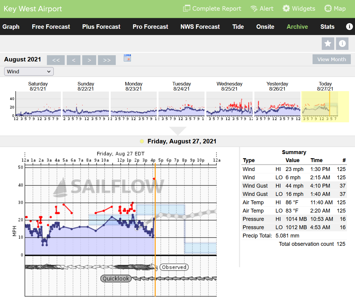
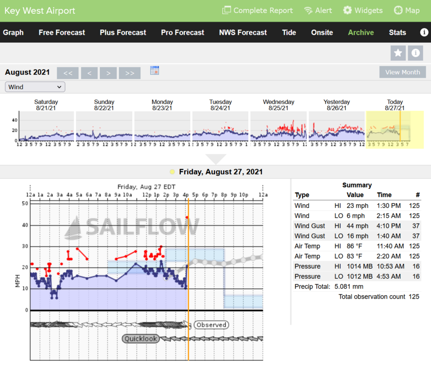
64 mph gust at Key West Airport at 1:25 am this morning.

-
I wonder if Ida will be able to maintain a "perfect" eye while in the Gulf. It should, conditions seem right. Yet so many Gulf storms I remember in the past few years have had trouble. If Ida's eye has problems, it would obviously affect peak winds. But what about the rest of the storm? Such as size, surge, and rain? Just wondering...
-
I guess if the water gets deep they can stack up milk crates to stand on.
-
We know how well that worked with Katrina.
-
Several weeks I ago I said Ida would the historic storm of the season. A few days ago I said, "Nah, I don't think so." Well, maybe I was right first, wrong second.
-
44 mph gust. Competing with Elsa and Fred.
-
I was like, WTF is that. Few minutes later was looking up "Milk Crate Challenge" on Google. Yikes!!
-
I will say I am usually up before dawn and am known to be one the first to drive around checking damage and storm surges. Lucky to have a good friend and client who is a tree service guy. Our home is one of the first on his list for his predawn drive and a few times after storms we are texting at 5:00 am.
-
Imagine the traffic jam tomorrow night if Ida stays on track and strengthens like the models predict. I wouldn't want to be in that. I'd prefer to be in one of the remaining hotel rooms that people who leave today can get lucky to check into to.
-
Some of us who live in Hurricane prone areas just chase at home. I expect one day I will be posting the moment by moment videos and pictures until we lose power and internet access. I hope it is not Ida, but so far appears it will not be a Florida Gulf Coast storm.
-
Wow! First time this year for a tropical storm?
-
How old are your kids? If it becomes a Cat 5 get your kids outa there! You can stay and report, take videos, and photos.
-
There is this one model:

-
Since I don't think it will do much, and not thinking of preparing, a hard turn into Tampa Bay is likely...
-
@turtlehurricane Yea we in Florida always want that close by pass of the biggest storm. We live for that sometimes! When we posted our predictions I think I said Ida would "the" historic one for this season. But it is earlier than I expected and just don't feel it much. Too fast, still not much to look at, etc. The models show a storm with potential, I see that. Maybe it will ease east and north, or not. I enjoy the anticipation, but not holding my breath for a wild storm-chasing live event. I do suspect I was wrong about Ida being the historic storm of the season though. (But being wrong is something I am used to!)
-
The New Orleans "Night Tripper" died on Day 157 in 2019 the same day as a good friend of mine who got lung cancer from asbestos on ground zero in NYC helping his city he loved so much after 9/11/01. Maybe he was in “Right Place Wrong Time”. Dr. John is known for loving his city as well. RIP to both.
-
Ida to hit New Orleans. Watching "Live and Let Die" when I was 13 was memorable for me and my first taste of Tarot. New Orleans was also memorable to me. The three forever intertwined in my mind. Even when Katrina was approaching and pounding NO the concept of 007 and Tarot were in my mind. Curious that my fate so many years later has taken me to learn about Dr John Dee, who Prospero is based on, the "Original OO7".
-
Perfect! I have been holding back a bit.