NorthHillsWx
-
Posts
7,685 -
Joined
-
Last visited
Content Type
Profiles
Blogs
Forums
American Weather
Media Demo
Store
Gallery
Everything posted by NorthHillsWx
-
I’m going all in on 90L. Bathtub water, decreasing shear, unstable air mass, and location location location. SW gulf is a hotspot for quick spin ups (orientation of geography?). Given the well organized look seen this morning would not surprise me that any additional increase would lead to formation of a TD by tonight. I think 90L wins the race for “W” and I think it could also become our next hurricane. Going to be a painfully slow mover and since no vortex exists yet models have taken up almost every inch of the western gulf for possible tracks. I personally think a long northward trek into Texas is most likely, but will need a defined coc before we know anything on that front
-
Yes, it’s a good thing we cancelled this season halfway through August because the globals weren’t picking up on development. I can’t imagine if this had actually turned out to be an active season!
-
Teddy should get us there alone
-
Honestly we may need a thread for 90L. Looks robust this morning. Models have slowly been picking up on it, albeit weak, but as we just learned: never trust a gulf system. Another slow mover that may eventually work towards the Texas coast
-
Hits a brick wall
-
The crazy thing about that run, well besides 3 hurricanes lined up in a row, is it doesn’t landfall any of them haha
-
3 US hurricane landfalls (all strengthening on approach), one of the strongest storms to ever hit the US, and being on the “N” storm by September 1st sure doesn’t feel like a season bust!!!
-
I’m anxiously watching to see what they find. This is a beautiful satellite appearance to not have a closed center. Has expanding outflow and persistent deep convection where you’d think the center should be
-
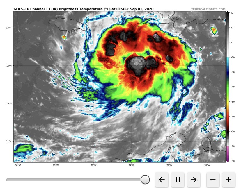
99L looks healthy tonight.
-
Could see 2 more named storms in the next 12-24 hours. 99L has some potential to make a run at becoming a hurricane. 90 will be a wave producer on the east coast. Both look robust at the moment for invests. Hopefully 99L continues its rapid pace of movement to decrease strengthening and also flooding issues where it makes landfall in Central America
-
CMC solution of multiple TC’s in GOM at same time is quite interesting. No reason to focus on model to model runs though. Signal is there for tropical cyclone genesis and very little to no chance of recurvature with that massive blocking ridge in place. As said above, could get interesting this week.
-
Based on satellite and radar, I believe we have another storm off the east coast... Here in Nags Head for the week and you wouldn’t know it. Very little swell, few rain bands moving through.
-
Love people declaring the season a bust when we’ve already had over $5 billion in US damages alone, record breaking 10th named storm by August 13, more than a week ahead of 2005, and seen storms popping in even unfavorable conditions. Wait till the Atlantic gets right here in a couple weeks...
-
They’ve been atrocious with storms this year. But, they do not get into the meat of the favorable period as advertised by the above posts even in their longest range.
-
99L looks like it’s on it’s way to becoming a depression. Very much improved convection overnight
-
Bathtub water in all the places where it’s most dangerous
-
Invest 99L has my attention. Decent mid level rotation and not ridiculous amounts of shear. If it can overcome some dry air, especially to its north, and a relatively stable atmosphere, it may be our first shot at a MDR storm as it heads generally towards the windward islands. Has held its own despite unfavorable conditions thus far
-
Got a localized drought going on at my farm in Franklin county SW of Louisburg. Last measurable rain was on June 14th. Beans and tobacco have about 1/3 the normal growth this time of year and it is a legitimate dust bowl when driving down the dirt road. Crazy how some areas just seem to miss every storm in these summer patterns. Praying for rain but I worry our crops have already failed as we do not have irrigation and the current sad state has their growth potential limited.
-
Let us know what real snowstorms are like. Congrats on getting on the good side of 85 by a lot!
-
With those years, how many had 2 purely tropical named systems (not sub-tropical storms as we frequently see in early season) before Hurricane season?
-
Just named Bertha
-
Video I took of squall line that pushed through the morehead city area last week and caused some minor roof damage to my house.
-
I'll try to upload videos later. Pretty intense stuff for a squall line
-
Don't know wind speed but had to be 70+ in Morehead City where I'm at when that line came through. Did something to the roof because we have water pouring in through the ceiling. I was here for Dorian and had not such issues. Didn't blow trash cans over. They're in the neighbor's yard across the street...
-
Storms look isolated at best per Hi-res modeling. Hoping for widespread rain to pan out Sunday without a severe threat. It is getting dry.