MarkO
-
Posts
3,402 -
Joined
-
Last visited
Content Type
Profiles
Blogs
Forums
American Weather
Media Demo
Store
Gallery
Everything posted by MarkO
-
I've seen traffic on 93 back to almost pre-Covid levels the past few weekends.
-
Touche! I've broken collar bone and humerus, dislocated shoulder (twice), sprained knee and thumbs, been impaled in the arse by a fallen tree. Lost unknown toe nails due to oversized boots, bruised ribs and probably dealt with minor frostbite, frostnip on countless occasions. But the scariest of them all was falling into a tree hole at Stowe that took me over 1/2 hour to get out.
-
I think it'll be a big mistake if they don't loosen up restrictions. The feared transmission from urban southern New England states to rural northern NE counties never materialized. Skiing is probably one of the safest activities I can think of.
-
yes, Sundae River.
-
I think 2010-2011 was pretty good for the 128-495 belt. I'm wondering how the Whites did... now that's where I'm calling home in winter.
-
Anyone have a map of how NE did in 10/11? Who were the winners and losers?
-
If I were them, I'd blow out some mice tomorrow morning for some cheap PR. Low dew's and 31F for a low would likely make it possible. Edit, looks like temps and especially dew's won't be low enough.
-
Great, another virus/bacteria we need to worry about. On a happier note, I'm seeing first flakes fly at Breckenridge. Bring on winter!
-
Might as well watch the temp drop and radar flip: https://www.wunderground.com/wundermap?lat=39.47&lon=-105.95&zoom=11&type=hybrid&units=english
-
They always seem to get heavy snows early in the season. Usually the first ski area to open 100%
-
It is insane. Denver forecast high in mid 90's today and winter storm watch tonight.
-
This rapid intensification makes sense. Good outflow, low shear, decent forward motion and very warm SST's (Harvey mentioned 85F). Even if it's churning up, it's still much warmer than other tropical areas. That shelf is only a couple hundred feet deep. Storm surge is going to go way the hell inland. 25-30 miles.
-
Cat 5 at landfall may be probability and not a possibility
-
There's a FEMA .kmz file you can download and display on Google Earth. The 100 year flood zone extends inland about 25 miles from the coast. It does not appear there is many that live in this area, but I sure as hell hope those folks that do evacuate to higher ground.
-

May 8-9 mid-spring rain, snow, cold, wind obs
MarkO replied to CT Valley Snowman's topic in New England
2" on the bald bishop. 29.2/26 -
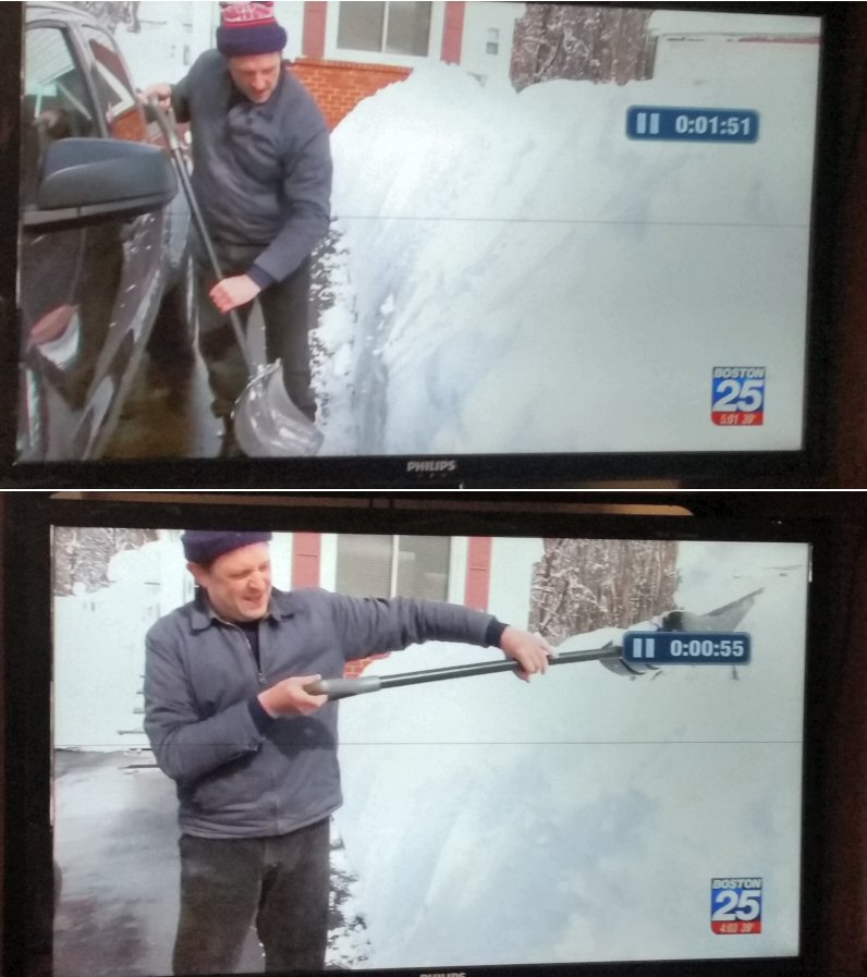
I just watched the segment again, he was out "5+ hours yesterday and another hour today just cleaning up". He might just be a bigger weenie than you!

-
Fox 25 reported from Wilmington and they have their own RevKev who sculpts his driveway banks as obnoxiously high as possible. Too funny!
-
I actually got close to 6" in that 90 or so minute burst under 35dBZ returns, but I found it so hard to believe (4"/hr!?!??!) that I rounded down to 4.5". Of course when I post totals, I usually caveat "unofficial".
-
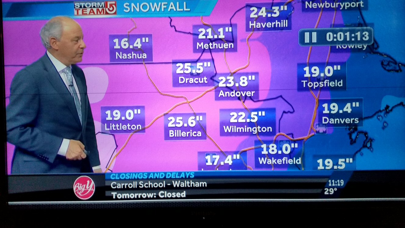
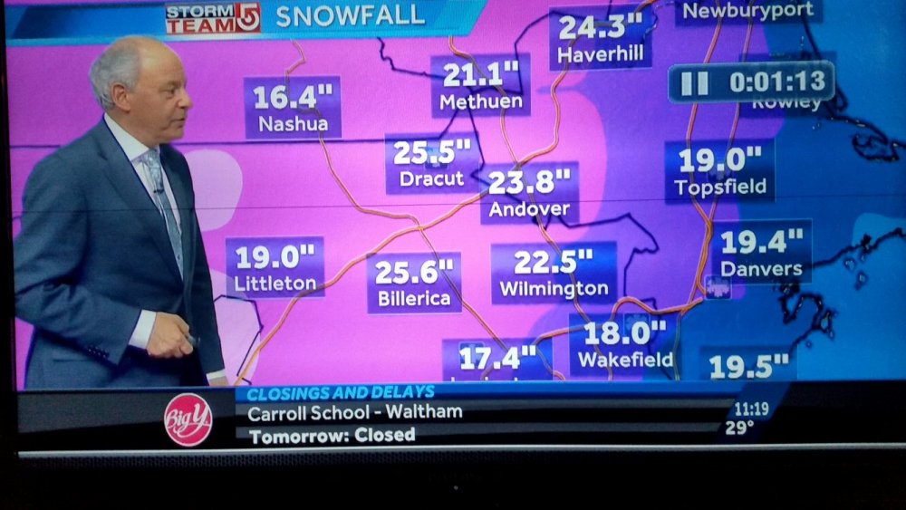
The controversy regarding Ray's 31" was just on the news (ch 7).
-
I'll back Ray up , all you got to do is go back in this thread. He was a couple inches ahead of me and that death band sat over him longer than me. Watch the radar loop.
-
Bullseye just south of me. 'grats Ray!
-
Congrat's Ray! Epic storm.
-
Yeah, we (up north) don't get the 12"+ storms, but don't you worry, you'll get yours tonight and tomorrow and Thursday... I don't think I get an actual snow "pack" around here, but up north it will linger into mid April, maybe longer!
-
link?
-
20.75" 29.2/28