MarkO
-
Posts
3,364 -
Joined
-
Last visited
Content Type
Profiles
Blogs
Forums
American Weather
Media Demo
Store
Gallery
Everything posted by MarkO
-
Yeah, Killington pounded all night. Still going strong. Noticed a bit of an inversion at MWN, but probably not enough to curtail operations. With the low dew's I wouldn't be surprised if Killington (and Sunday River too) blow snow all day/night. Good snowmaking weather continues into next week. Expect some resorts to open. I think Killington maybe as early as tomorrow.
-
Haven't been there in a while, but I'll have to check it out this winter. Same with Tenney.
-
That epic pass does sound epic, I'd certainly do it if I could, but because of my location, I usually go with the White Mountain super pass (WV, Cannon, BW and Cranmore) and even though I buy it in April, it still costs over $1000, ughh. On a positive note, if you get one and you've got kids under 13, you can get a kids season pass at WV if you rent skis (about $150) from Ken Jones in Manchester. I heard Killington will blow snow to open as soon as possible, but looking medium range, it's not looking possible for at least a couple weeks, but who knows?
-
Greta Thunberg "likes" this photo
-
Superstar cam says 2019-2020 has begun https://www.killington.com/the-mountain/webcams/mountain/superstar-cam
-
August turns in New England.
-
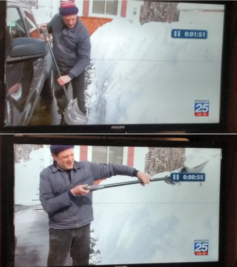
I just watched the segment again, he was out "5+ hours yesterday and another hour today just cleaning up". He might just be a bigger weenie than you!

-
Fox 25 reported from Wilmington and they have their own RevKev who sculpts his driveway banks as obnoxiously high as possible. Too funny!
-
I actually got close to 6" in that 90 or so minute burst under 35dBZ returns, but I found it so hard to believe (4"/hr!?!??!) that I rounded down to 4.5". Of course when I post totals, I usually caveat "unofficial".
-
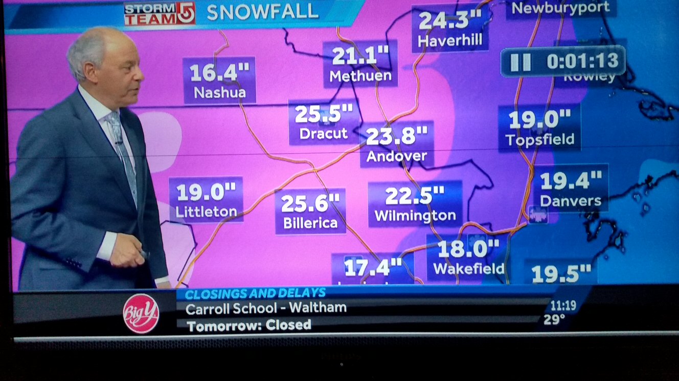
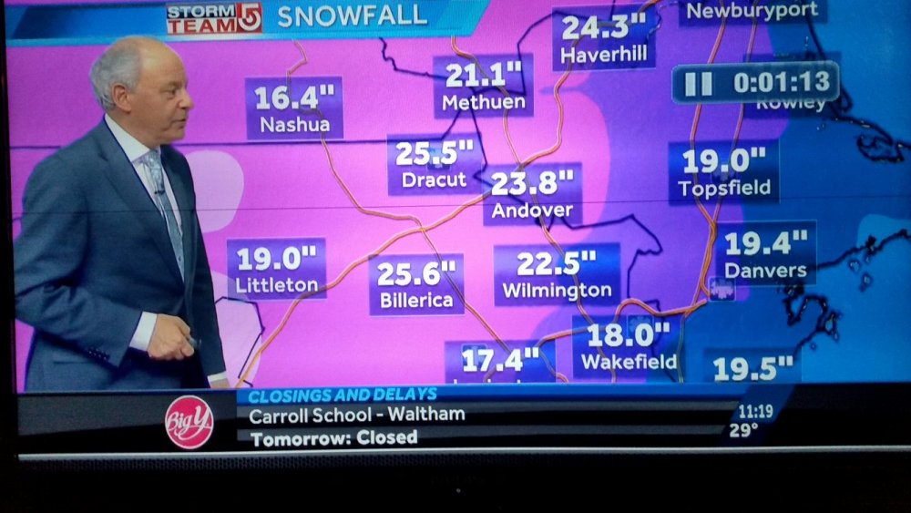
The controversy regarding Ray's 31" was just on the news (ch 7).
-
I'll back Ray up , all you got to do is go back in this thread. He was a couple inches ahead of me and that death band sat over him longer than me. Watch the radar loop.
-
Bullseye just south of me. 'grats Ray!
-
Congrat's Ray! Epic storm.
-
Yeah, we (up north) don't get the 12"+ storms, but don't you worry, you'll get yours tonight and tomorrow and Thursday... I don't think I get an actual snow "pack" around here, but up north it will linger into mid April, maybe longer!
-
link?
-
20.75" 29.2/28
-
Taking that official 14" for Lowell (arguably low/actual measurement) at 4:30 and adding the 4.5" since then and we're at 18.5". Looks like a 20 spot is all but guaranteed.
-
Congrats, but I believe you might bust on your forecast!
-
Heard another report in Lowell of 14" at 4:30. That would mean they're close to 16" by now, but I think that report was probably an actual measurement.
-
I was taking measurements this AM when I was about 2-2.5" behind Ray. Haven't taken a legit measurement since then, but I'd wager we're pretty close to Ray since the returns had been generally heavier this afternoon. He's also only 6 or 7 miles to my southeast. I'm guessing about 18". Ray, what are you at?
-
Just getting crushed in Lowell under 35dBZ returns. Starting to worry about the white pines. Boughs are nearly touching the ground, that's usually when the upper ones start to give. Wind is pretty light, 29.2/28.
-
Yeah, that band you got skipped over me, gave you a nice head start. It's been better here overall this afternoon.
-
Some of the heaviest snow of the day. About 2"/hr stuff and it's looking like a couple more hours of it.
-
Been dumping since about noon. Looks like a few more hours of this then an inch or two overnight. I think 20 burgers from 128 up through southern NH into Worcester
-
What have you gotten so far? Any core samples?