crossbowftw3
-
Posts
1,401 -
Joined
-
Last visited
Content Type
Profiles
Blogs
Forums
American Weather
Media Demo
Store
Gallery
Everything posted by crossbowftw3
-
Upstate/Eastern New York
crossbowftw3 replied to BuffaloWeather's topic in Upstate New York/Pennsylvania
GFS ticked back slightly west but it does nobody here any good, not even us in BGM CWA. @sferic @Ericjcrash maybe some flakes for you two tomorrow. -
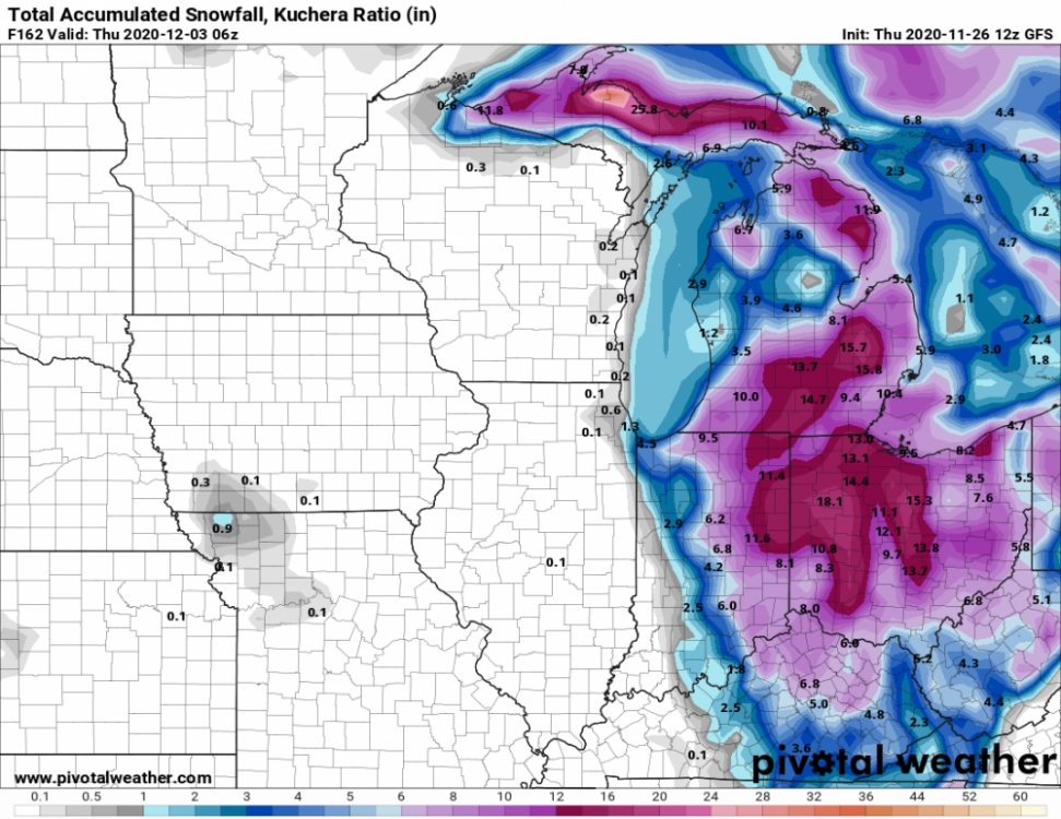
Latest GFS. You could in theory drive from Chicago to Cleveland and go from nothing to well over a foot.
-
Gonna be interesting to watch what happens in Ohio/Indiana. Potential very sharp snow gradient might be in play....talking nothing to at least a foot within maybe 30 miles. If not less, that is.
-
Plausible knowing that every so often the southern states (mainly NC) get a snowstorm, with results never really pretty.
-
Wouldn't shock me knowing that every year or so the south always gets a storm or two in December-January. The results never tend to be pretty.
-
There's been six known instances of max wind potential (105 MPH gusts) in any watch, most recent was just last year across Minnesota and Northern Wisconsin
-
1630 outlook further expands the moderate risk into NW Wisconsin, with rather concerning wording at hand. 7000 SBCAPE pooling in SE ND already. https://www.spc.noaa.gov/products/outlook/day1otlk.html
-
2020 Mid-Atlantic Severe Weather - General Thread
crossbowftw3 replied to Kmlwx's topic in Mid Atlantic
6/3/14 for wind, hail cannot go past moderate. most recent PDS severe watch happened August last year. -
2020 Mid-Atlantic Severe Weather - General Thread
crossbowftw3 replied to Kmlwx's topic in Mid Atlantic
The case of lower Michigan might be one where a PDS severe watch is warranted only if the tornado threat was slightly lower. It's still entirely plausible under current circumstances, however. For us further east folk it looks like limited forcing today. -
It is. coincidentally on the same date as Lee County from last year.
-
No longer waiting for Cookeville. EF4 with winds of 175.
-
Hearing from other forums that Tennessee EMA Spokesperson now indicating at least 28 deaths, 200+ injured.