crossbowftw3
-
Posts
1,394 -
Joined
-
Last visited
Content Type
Profiles
Blogs
Forums
American Weather
Media Demo
Store
Gallery
Everything posted by crossbowftw3
-
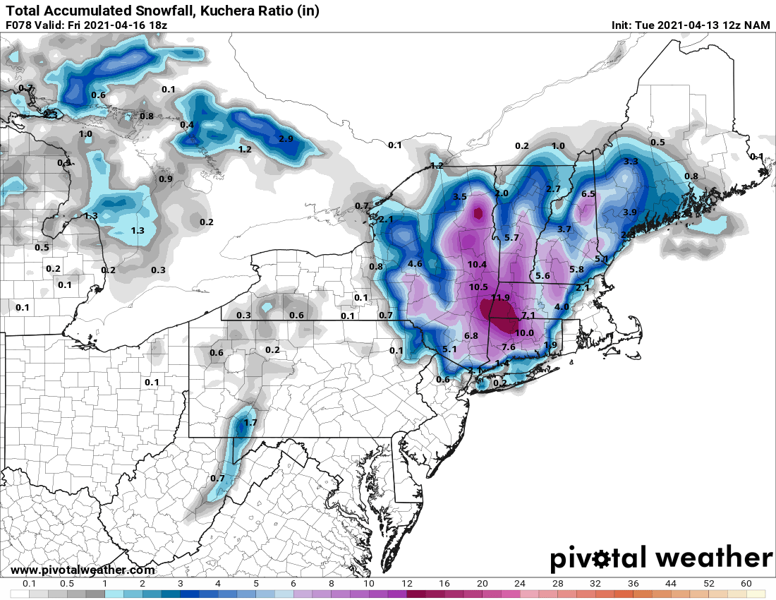
And the ensuing snow map, beginning to wonder if I simply end up too far west for anything really meaningful in the Catskills:

-
Finally starting to seem like models are converging to one common idea, devil will be in the details if my lower elevation in the Catskills will see more than 1-2”
-
Upstate/Eastern New York
crossbowftw3 replied to BuffaloWeather's topic in Upstate New York/Pennsylvania
First consensus forming? -
Looks like at least the overnight model runs are in fact converging on a first consensus though, effectively now looking like you need to go far beyond 84 to see snow
-
Most trees still are only beginning to bud out around here.
-
He’s back to smoking the good stuff. A much more plausible forecast for this juncture would be broad-brush 1-3/3-6 with up to 12 in the elevations
-
Remember the catch-22s that make snow totals being that high highly unlikely, snow is definitely growing probable for your elevation. EC is otherwise all on its own when it comes to this.
-
Upstate/Eastern New York
crossbowftw3 replied to BuffaloWeather's topic in Upstate New York/Pennsylvania
Midday GFS with a far more plausible snow distribution for this time of year: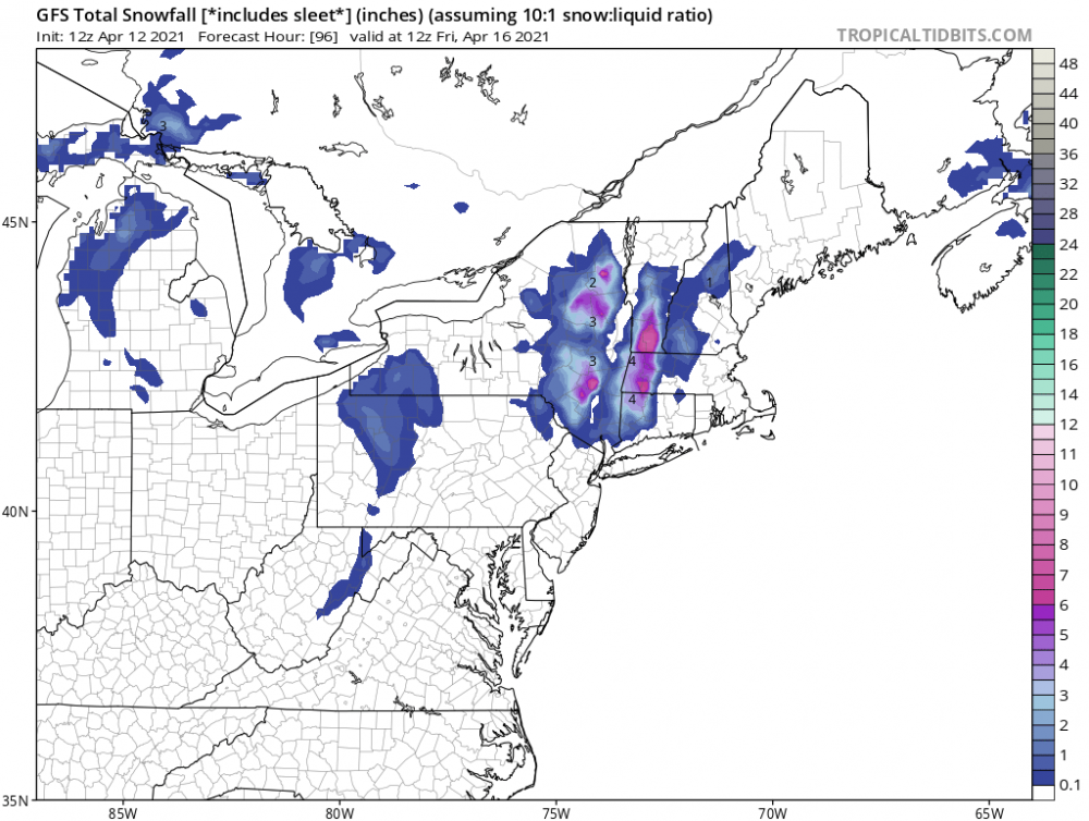
-
Midday GFS makes much more sense with the snow distribution to elevation ratio, maybe a first look at how this might actually unfold?:

-
Midday GFS beginning to really show a far more plausible scenario when it comes to snow distribution for a storm this late:

-
way more realistic snow:elevation distribution for what you'd expect for a late seaon storm.
-
Matter of fact, midday GFS is already showing signs of slowly coming to a realistic scenario
-
GFS has lost its mind apparently. Definitely not going to verify at even 50% of this. A much more realistic scenario should become apparent with each successive run; which probably confines most of any snow to >1500 foot elevations
-
Quick examination of models tells me that any snow would need to be falling at high rates to offset the 33-34 degree temperatures that may be present this weekend, with the only factor working in this thing’s favor is that it could fall at night. Conclusion: we should see things even out as the week progresses; lower elevations maybe see up to 4” of slop while higher elevations see more.
-
Quick peek at models implies any snow this weekend upcoming would be falling into 33-34 degree air, albeit at night where it’d be most favorable—rates would need to be incredibly heavy to offset. I doubt GFS (most aggressive?) plays out verbatim and eventually we should see it even out for us (relatively) lower elevation folks to where we would probably see ~1-3” of absolute slop whereas someone at those elevations could cash in. Regardless, this upcoming pattern looks rough. We never seem to get true spring anymore before summer just blows right in.
-
not overly likely with snow falling into 33-34 degree air, but then again I did say that before the snow event last April. Got 2.5" of slop here and wouldn't be shocked if something similar did happen.
-
It legitimately feels like deep winter out there this morning. 26 with a dusting of snow OTG and currently light snow showers.
-
mood flakes. 34/33 nothing sticking (shocking I know)
-
Upstate/Eastern New York
crossbowftw3 replied to BuffaloWeather's topic in Upstate New York/Pennsylvania
this looks so wrong for so many reasons. -
Of course, comparatively speaking I only have 750-800’ whereas Liberty is 1500’. 1-3” for the far NW people still works with him probably winning the jackpot at 4” or so
-
6z came back west also I doubt you get 6” of snow when considering this is happening in the morning. Gotta account for sun angle killing ratios. Even if you get moderate snow for 4 hours or so. You need some impressive rates for this time of year to make it stick
-
Upstate/Eastern New York
crossbowftw3 replied to BuffaloWeather's topic in Upstate New York/Pennsylvania
Either way it would seem WWAs would be needed for the rest of BGM/BUF WFOs probably by midday tomorrow -
Preferably even closer to Syracuse. They’ll get smacked up there. Pretty high ratios for them too at up to 14:1 (after the initial transition being closer to 4-5:1) so snow growth should be very favorable.
-
If the low was further SE that’s how we get into the 2-5” range for snows here
-
Still possible but CNY is all but locked in for a more significant snow. If we get lucky we can see 2-5” here