

Kmlwx
-
Posts
13,333 -
Joined
-
Last visited
Content Type
Profiles
Blogs
Forums
American Weather
Media Demo
Store
Gallery
Everything posted by Kmlwx
-
Then again - it's the HRRR and could be totally wrong - but with agreement maybe not.
-
HRRR continues to send the most continuous part of the line mostly to the north of Central Maryland. It's more broken in DC proper and very scattered south.
-
Wish we could muster dynamics like today with sunny skies in May.
-
LWX did note yesterday that it might come in a bit faster than expected with how dynamic it is. I can barely make it past 9:30pm myself these days.
-
The high risk better be squarely centered around my place of residence.
-
I don't believe there has been a high risk anywhere in the northeast since 1998.
-
@Eskimo Joe, @yoda, @high risk - @George BM is calling for SPC to issue a HIGH RISK for somewhere in the Mid-Atlantic or Northeast
-
Destined to flip at some point. Likely just in time for spring. April is bound to be rainy and raw.
-
The low pressure on the Euro doesn't pass as close to us as the event a few weeks ago. But the H5 chart is ripe looking.
-
It looks really nice. I wish CIPS Analogs ran on the Euro...would be interested to see what that spit out. 132 hours away isn't even that far...
-
I'm about to look...if I am not blown away I will be disappointed.
-
@csnavywx thanks for the great explanation for us weenies!
-
And in the morning no less. Very, very impressive event even by normal severe season standards.
-
This is only the beginning. Here's the seasonal projection from the weenie simulation - Rest of February - Not much but maybe some gusty showers March - Regular bouts of severe synoptic wind following behind monster lows with squalls and wedges rapidly raking the area. April - Regular bouts of moist, warm air clashing with high shear events to warm us up for peak season. May - Daily wedges June - Daily wedges centered on the mall.
-
Low CAPE, high shear events fail for us like 90 percent of the time.
-
Let's do this again with 80+ degree temps and 65+ dews.
-
We always seem to "luck" our way into at least one severe weather "event" every February. Then we usually go mostly dormant until April or May.
-
I looked at the CFS supercell composite maps on the COD page last night. This winter sucks.
-
EF-2 is exciting from a distance - but locally it's just too populated to hope for anything like that. Imagine if we pulled a prolonged ring of fire derecho pattern and then topped it off with a tropical system in the fall. Would easily make up for a dreadful winter (barring late turn around).
-
This is an excellent start to the thread. My only issue with derecho patterns is that they can be very hot ones...worth it for excitement I guess.
-
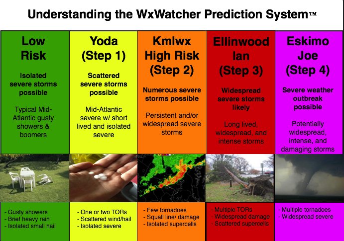
It's only January...but with the winter season looking incredibly bleak...let's fire up the 2020 Mid-Atlantic Severe Disco Thread. May our lack of winter weather this season forebode a spring and summer FULL of the folllowing @yoda copying and pasting @Eskimo Joe being bullish on events @mappy getting to break out some GIS skills on something local @Ian popping in to tell us the upcoming pattern looks ripe @high risk with ample opportunity to educate us and keep our hopes high when it looks like we won't get sun before an event. As a reminder - the Mid-Atlantic Severe Weather Reference Scale is displayed below - @WxWatcher007 to credit for this. Let's shoot for a moderate risk in 2020.
-
The phase it's in when it heads for the COD is important. A COD visit after going into phase 8/1 is different than it dying after being in the unfavorable ones.
-
When it increases the weenie looks even more.
-
In the business of long range forecasting - the bolded portion is NEVER a safe thing. There should *always* be doubts when dealing with things beyond day 7...let alone day 10 or 15.
-
Well yeah. I'm not dumb Wasn't it you that said they simulated a scenario where the water would stop running etc.


