ORH_wxman
-
Posts
93,092 -
Joined
-
Last visited
Content Type
Profiles
Blogs
Forums
American Weather
Media Demo
Store
Gallery
Everything posted by ORH_wxman
-
Area is more accurate if you want to know the precise value of surface that is covered with ice. Extent is better for things like shipping...if a region is covered with 40% ice concentration, you probably don't want to try going through it without an ice breaker. That region would be considered "covered in ice extent" even though there is open water mixed in. Area would give us a lower value because it's only 40% ice.
-
Lol....I usually wonder why I wasted the 5 minutes doing that instead of something more productive.
-
I barely look at the Euro weeklies....I can't remember the last time I looked at the CFS weeklies. I may have done it a couple times last winter.
-
Posted in the other thread that late November looked colder on the weeklies with western ridging....but it's week 6. Almost no skill. It does look like we warm up after the colder wx in the first few days of November.
-
Late November looked colder with western ridging on the weeklies....but I don't have to tell you that week 6 has almost no skill.
-
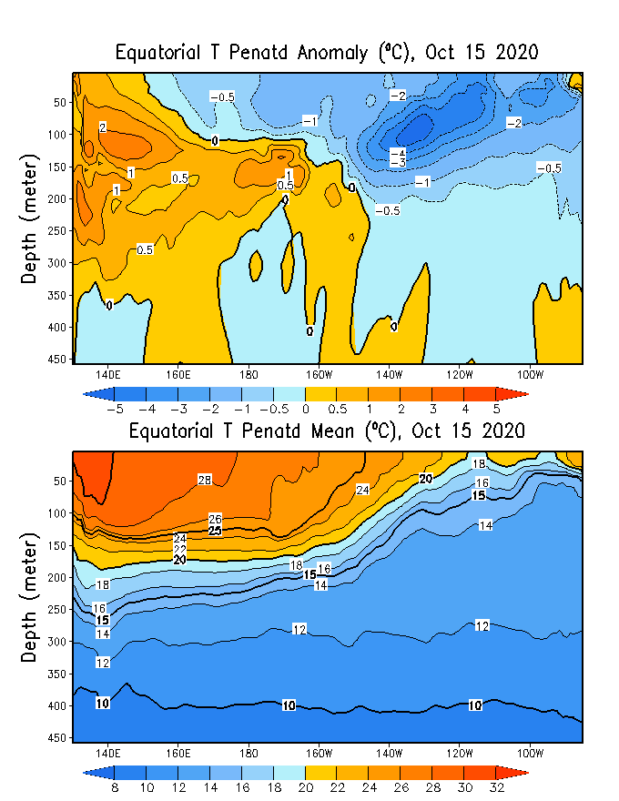
Moderate Nina....looks like we will continue to see the colder subsurface rise to the surface in central and eastern areas with the easterly wind bursts continuing.
-
Yeah Nobscot Hill is over 600 feet. Most people prob dont think anywhere in Framingham gets that high, lol.
-
Is that taken from nobscot hill?
-
For sure. One of the reasons we go to western ME so much is it’s off the beaten path somewhat. We love that vibe more than the touristy feel. I do love North Conway’s views and they have a nice restaurant scene for when we want to do that kind of thing, but we don’t want a full week of it when vacationing. So we stay 30 minutes east. And yeah, Berlin could use your dollars any time, not just during covid, LOL.
-
Unfortunately without the good bourbon.
-
LOL...I remember seeing that movie in theaters as a teenager. Anyways, I’d go into Maine before VT if I was where phin is. That western part of Maine has a very northern NH vibe as it is.
-
Seems like there’s no enforcement. But they could always go the RI route and start pulling cars over....but they got a ton of backlash for that and eventually stopped, so it seems unlikely other areas will start doing it. But there’s a critical difference between winter and summer. Bigger chance of spreading in the winter when people are forced indoors more. Now you wouldn’t expect it at ski resorts too much as long as they are limiting lodge capacity, but we don’t know how other places will be affected. You get a couple stories of out-of-State skiers spreading the virus in a restaurant or something, all of the sudden you could see strict enforcement measures.
-
LOL I love the sun angle and warm ground myths.
-
The warning criteria snow I received on Nov 7, 2012 was totally fine, but the Oct 29-30 snow in 2011 totally doomed us.
-
Both are inhibiting factors to the length of the season. Severe drought really helps mute the colors too, though the drought wasn't that bad up there compared to some spots down in SE MA/CT/RI. Definitely helps to have a windy rainstorm, though a lot of places were already passing peak by that point in NNE which made it easier to drop the leaves. Down here, we weren't quite at peak yet, so we still had plenty of leaves afterward even though we lost plenty of branches during the derecho.
-
Yeah that early freeze really shortened the season....it may not have muted the colors too much, but it definitely helped the leaves change early and then fall off quickly.
-
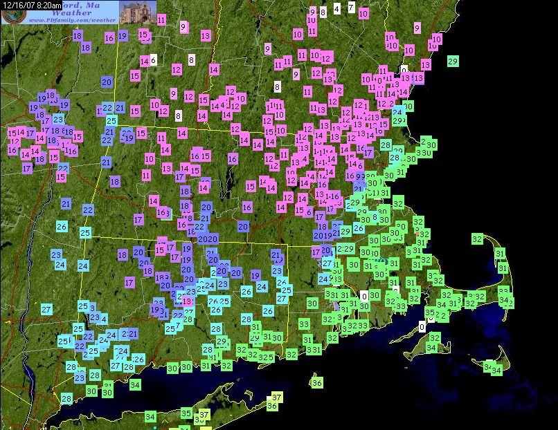
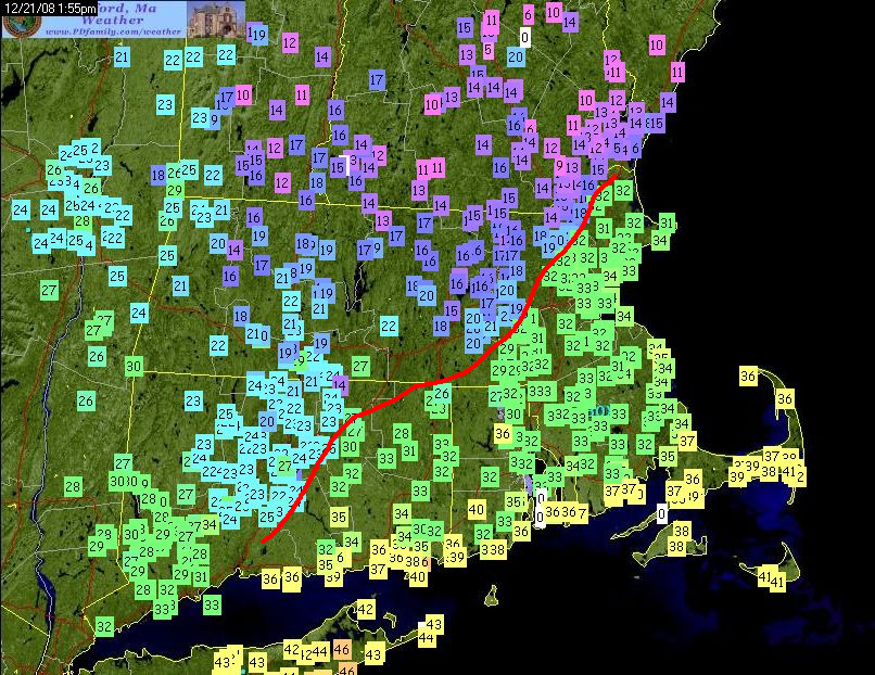
Here's temp maps from the 12/16/07 and 12/21/08 events....Amesbury is just west of the CF on both of them while it's torching (relatively speaking) out on Cape Ann and even in Newburyport.
-
Oct 2007 was an absolute furnace though....so big difference in the CONUS pattern where 2020 will likely finish below normal for a chunk of the plains and midwest/lakes. Prob will still finish above normal here in the northeast as we're going to be east of the best cold over the next 10 days. But that doesn't mean winter can't be similar. There are definite similarities elsewhere and in the tropical PAC.
-
Yeah Rockport is literally like in the water....it's east of Gloucester. Amesbury can frequently be just west of the CF.
-
I think it makes sense....easterlies migrating eastward is going to keep the Nino1+2 and Nino 3 regions colder than otherwise.
-
It is especially true in La Nina....you can sometimes get away with a mildish Canada in El Nino.
-
Those “changeover from W to E” events with NW flow do that even down here. They aren’t that common but I’ve seen places on the west slopes of the ORH hills toward Hardwick and Ware even at lower elevation get 4-6” and then we barely get an inch or two in ORH. They are sometimes to fascinating to watch even though they would drive me nuts.
-
Yeah those west side places are smoking...you can see how well Alex is doing even down at 1500 and change. Cannon always gets hammered on that type of setup.
-
NW flow is def going to favor the straight west side more...especially in changeover events. Those will be pretty rare once winter gets going and most precip is snow, but advecting the cold in from the NW is going to be way more efficient to the west. The Pilot range to your NW prob made it a little less efficient advecting the cold in.
-
Coop guy is 1740 or something. I think 1300 is the elevation down along rt 2. His place is up the slope at 1500.