


ORH_wxman
-
Posts
93,110 -
Joined
-
Last visited
Content Type
Profiles
Blogs
Forums
American Weather
Media Demo
Store
Gallery
Everything posted by ORH_wxman
-
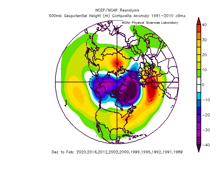
Scott, here is the last 30 years or so of our garbage winters. The NAO and the AK pig stand out well.
-
Yeah not sure why he’s implying the PAC looks like those composites. The PAC looks way worse than that over the next 10-12 days...now, it may improve after that, which is reason to get more optimistic assuming west-based blocking develops.
-
It’s often behind the grinch storm we typically see, lol. But there wasn’t much cold behind this one. Doesn't look like any true arctic air for the foreseeable future. May have to wait until mid-month or later.
-
EPO never gets great on weeklies but it doesn’t have to if the NAO/AO ends up like it depicts. It goes into a bit more of a neutral state and the PNA ridging pops a little more. It’s not a cold pattern up here but it is a good one for snow events. Definitely a cold pattern down south though. Weeklies could be wrong though. They don’t have a lot of skill beyond week 3.
-
Weeklies gone wild from mid-January onward....PAC gets better and NAO blocking looks more classic. Let’s hope it is right.
-
Yeah this makes sense. A strong NAO/AO with a garbage PAC basically lets you barely tread water in the northeast. Though you could prob do a little better if the block is specifically in the Davis Strait area... The PAC hopefully gets less hostile by 1/10...even just a mediocre PAC with a good NAO would do pretty well during peak winter temperature climo.
-
At least 1/4 has a better airmass than 12/5 so interior would prob be ok but it needs some help aloft with the intensity.
-
Assuming GEFS is correct. EPS not as enthused though they still do improve somewhat toward the end of the run.
-
Dec (Edit: Jan1/..2 ) multi-faceted ptype mess potential...
ORH_wxman replied to Typhoon Tip's topic in New England
True crippling ice storms are pretty rare. We get a lot of nuisance ice events and even semi-regularly we get moderate ice events in the interior. But they almost always fail to reach half an inch of accretion. (Radial measurement, not flat...big difference which causes confusion on here sometimes) You usually want a mesolow poking NE or NNE off the coast to really lock in the cold/dry dewpoint drain to offset the latent heat release of ZR. When the mesolow is oriented and poking more E or ENE, then it becomes harder to sustain the cold drain. So you’ll get some ZR for sure on that look, but then it ends up slowly going to 33F rain. You also need the QPF. Accretion efficiencies are often in the 0.7 range or even lower on moderate/heavy precipitation, but they will be much higher on light freezing rain. That’s also why many of the bigger ice storms come in waves of lighter precipitation that lasts for a couple days (or even longer like the 1998 ice storm in NNE) -
Stop looking at those damned charts and see the pattern. EPO sucks but the NAO is a fraud -NAO. It’s not a west-based Davis Strait or even Hudson Bay block. It’s eastern Greenland to Iceland ridging with a vortex over Baffin Island...in scientific technical lingo, that’s called a dogshit negative NAO. They can be ok when the PAC is mediocre but not when it is hostile. Previously, model guidance showed a true Davis Strait block which was going to offset the shitty PAC.
-
GEFS d15 pattern is definitely very good. But obviously not agreeing with EPS. For the first week of January, we will definitely have to hope for good NAO blocking to set up or we’re probably going to struggle with an AK vortex out on the PAC side.
-
Temporary one eyed pig setting up over AK early month too. We need the NAO to set up then or we’re gonna have a useless first week of January. It does look like the pig retrogrades west so it’s not locking in.
-
Lol. I’m guessing you prob avg 10” more per season than them.
-
I think NOAA hired the ecmwf.int graphics guys to design their radar.
-
I wonder if the PNS is wrong....they might have erroneously thought the report was 12.7" just for 12/17 so they added the 0.4 from 12/16 when the report submitted was a storm total.
-
What's up with Logan airport's snowfall total in CLI not matching the PNS? ...Suffolk County... Charlestown 13.4 426 PM 12/17 General Public Chelsea 13.3 258 PM 12/17 Trained Spotter Dorchester 13.2 240 PM 12/17 Ham Radio Logan AP 13.1 700 PM 12/17 Logan Airport CLI has 0.4" on 12/16 and 12.3" on 12/17 for a total of 12.7"
-
Yeah if that is the case, then I'd start being suspicious of deliberately bad totals from him....which is really not cool. Nothing worse than someone deliberately passing off unreliable data.
-
He could be totally innocuous in his measuring but just have a bad siting where the snow board location is prone to drifting or blowoff from roof or something like that which causes consistently higher measurements.
-
I’m sure when this goes through some reanalysis and scrutiny, we’re going to find insane ML fronto numbers along with super deep DGZ column. We had a beast arctic high up there and this was slamming up right into it with extreme negative tilt aloft. So my guess is the models prob undersold the ML fronto...even though it was already really impressive on guidance. The super deep DGZ always helps too because you aren’t needing to be very precise with where the lift is to get the cross-hair sig.
-
Yes I would think so.
-
Yeah this was a really weird storm. It was extremely well predicted in the medium range like a week-plus out but then it was kind of a short term disaster with model guidance inside of 24-48h.
-
I’ve become addicted to our Ariens snowblower. It just destroys huge snowbanks and drifts...or in your case, 30-something inches of snow on the level.
-
I’m looking around at totals and this was a massive snowstorm even if you totally eliminated that obscene fronto band. Like BOS to ORH to HFD/BDL down to NYC and back across a chunk of PA got double digits. But all those 13” and 16” totals all of the sudden look paltry when there’s 33” and 38” and 44” on the same map.
-
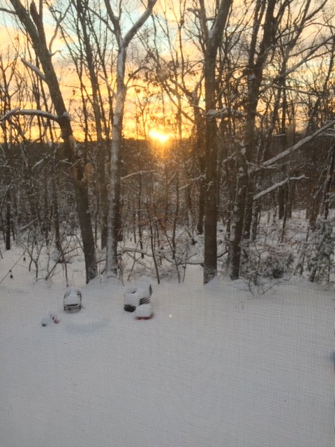
Nice sunset. Unfortunately I had to take the pic through the screen before the sun went behind the ridge but still a nice sight.
-
Getting a quick sunset now as the flurries have ended. What a site. Im guessing about 14” is our final when I check it out officially. Funny how 14 inches sounds so paltry when it’s an incredibly good storm in mid December. But when a mesoband is giving people 40 inches, anything else feels insignificant. Lol But what a great storm. Had some amazing rates last night and the snow has some meat to it. It’s not 20 to 1 blower. Prob like 12 to 1 or something.


