ORH_wxman
-
Posts
93,092 -
Joined
-
Last visited
Content Type
Profiles
Blogs
Forums
American Weather
Media Demo
Store
Gallery
Everything posted by ORH_wxman
-
If you had data for 2007-2008 there is a good chance that would be snowier than the other ones. That was a monster winter.
-
In the mod/stronger cases, it's usually hard to get a +PNA in a La Nina. We actually managed it for the first 2 months of last winter despite Nina being moderate....but then again, those SSTAs in the N PAC looked more like an El Nino. But even popping a +PNA for like 1 month during a La Nina can be pretty helpful....Jan 2011 and Jan 2009 are both +PNA months within a sea of otherwise -PNA pattern and they really gave the eastern US a sustained wintry period. Jan 2011's +PNA was well-timed too as it really popped big once the 1/12/11 storm reversed the big NAO block....so instead of a relaxation that comes with the NAO going more neutral/positive, we stayed cold and snowy with the +PNA ridge out west.
-
Yeah, I mean, if you have a -3 SD block in the Davis Strait, then that will definitely overwhelm typical Nina SE ridge climo for sure.
-
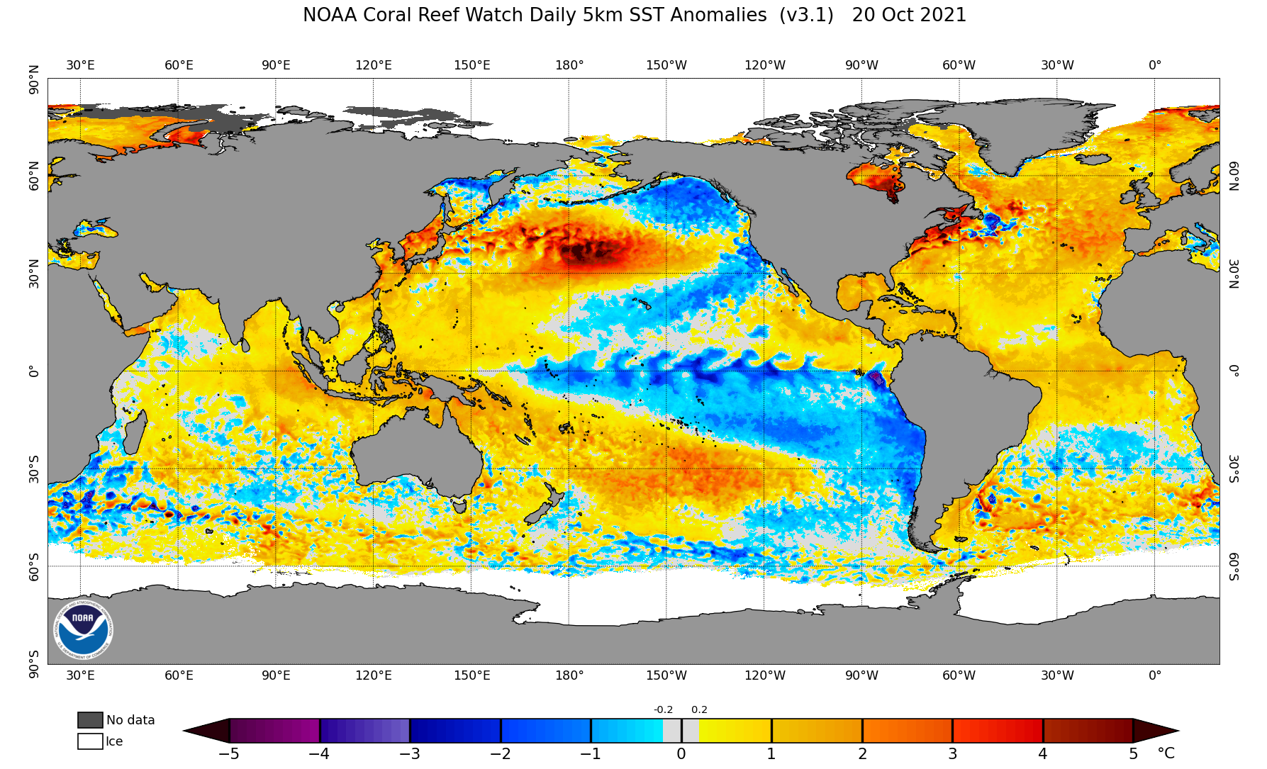
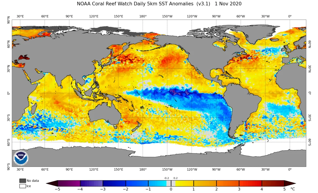
At least this year actually looks like a La Nina over the Pacific rather than just a thin strip of below normal SSTAs in the ENSO region....look at the difference between last year and this year I posted further above. Huge difference despite the La Nina actually being a little weaker this year....but in practice, it will probably act stronger and more typical than last year's did. That would be my guess anyway based off the look. That still doesn't tell us whether we'll get a lot of snow of course....you can have classic La Nina look still produce a total blowtorch ala 1999-2000 or 2011-2012 if a vortex sets up over AK/Bering Strait, but the other features will still be present like -PNA and SE ridge, etc, etc.
-
October Discussion: Bring the Frost-Hold the Snow
ORH_wxman replied to 40/70 Benchmark's topic in New England
Once you are west of Winni into the monads, it might as well be the fooking Allagash. Same thing once you are north of Berlin. There isn't much between Ossipee and Dover/Rochester NH either, though it's not as bad as those western areas of the state. -
October Discussion: Bring the Frost-Hold the Snow
ORH_wxman replied to 40/70 Benchmark's topic in New England
Yeah the closest thing to a ski village there in NH is probably North Conway at the base of Cranmore. Lincoln at the base of Loon can maybe be included too....but they aren't quite up to the levels of VT ski villages. -
October Discussion: Bring the Frost-Hold the Snow
ORH_wxman replied to 40/70 Benchmark's topic in New England
Yep there's a bunch of places you can move up there where it's a total wasteland for amenities. Most VT ski towns are pretty well supplied with them though whether it's Kmart, Stowe, or even Ludlow. NH can be a bit more sparse even near the ski resorts, but the White Mts aren't bad near Phin because of proximity to Berlin and Conway. -
October Discussion: Bring the Frost-Hold the Snow
ORH_wxman replied to 40/70 Benchmark's topic in New England
Berlin is actually sneaky big for a town up there....I'd bet most don't know that it's twice the size of Bridgton, ME over the border to the east. Even Lancaster isn't that much smaller than Bridgton. -
October Discussion: Bring the Frost-Hold the Snow
ORH_wxman replied to 40/70 Benchmark's topic in New England
Nah, by like the 2nd week of November, I'm done with the warmth because you can start getting more legit snow events. Plus, I'm a skier too and I like seeing NNE get off to an early start with both snow making and natural snow. Once my final yard cleanup is done around Veteran's Day, I'm all-in. I'm still realistic though....I won't throw a tantrum if we don't get a snow event in November....they don't happen every year down here. Up there they pretty much happen every year. Esp 2nd half of November. -
'08-09 was a weak La Nina (2nd year Nina)....it's actually not a bad analog for this season's background state. It's looking better and better too because of the PDO taking a nose-dive this summer and into autumn. You can also see the cool SST anomalies now extending from the ENSO regions to the west coast....that is something we have not seen since 2012 which had it lingering from the remnants of the 2010-2011, 2011-2012 Ninas. The 2016-2018 two year Nina didn't have it and neither did last year's Nina. This is a return to a more classic Nina SSTA pattern. Look at the difference between last year's Nina and this year's in the North Pacific from the west coast into the Gulf of Alaska. This is much more reminiscent of the Ninas from 2007-2008, 2008-2009 and the 2010-2012 episode.


-
October Discussion: Bring the Frost-Hold the Snow
ORH_wxman replied to 40/70 Benchmark's topic in New England
Don't worry, I'll be gung-ho cheerleading for snow when the time comes, but I just have no use for shitty cold weather in October. Even 10 years ago I really didn't, though I used to root a little harder for the rare October snow event. That said, if I was up there, I'd probably root for it more since it's easier to snow in October up there than here. -
October Discussion: Bring the Frost-Hold the Snow
ORH_wxman replied to 40/70 Benchmark's topic in New England
Yeah bring it on after Veterans Day. Usually when I do my final yard cleanup. Once that is done I want the snow in here...but we have such a lagged climo in New England. Its amazing comparing to the some of intermountain west (esp further south like NV/UT/AZ) where November is colder than February in many spots. -
October Discussion: Bring the Frost-Hold the Snow
ORH_wxman replied to 40/70 Benchmark's topic in New England
I mean, all of our frigid autumns in the 1980s and early 1990s were the highlights of the cold season....winter would turn to shit just in time...lol. 2000 was a good one though. Lasted right into winter. -
October Discussion: Bring the Frost-Hold the Snow
ORH_wxman replied to 40/70 Benchmark's topic in New England
My only quibble with this month. I love these types of days but it would have been nice to sneak in a quick cold shot a week or two ago that kills the bugs. But otherwise let’s keep the party going. I got no use for 52/27 type days unless I’m doing yard cleanup or something. -
Looks like their maximum snow depth was 100 inches in 2011-2012....they reached 107 inches in the 1989-1990 winter. Yeah most of their epic years aren't good here, though there are some exceptions. 2012-2013 was their 5th snowiest winter on record and it was very snowy in New England (not so much in the mid-atlantic though). 2000-2001 and 1976-1977 were also top 10 snowiest winters in Valdez which were prolific in New England.
-
Valdez had 438" of snow that season. 4th snowiest on record. 1989-1990 had 550" (!!)
-
I was in elementary school....it wasn't a huge deal over the interior, but it was windy and rainy for several days. I do remember all the news footage of the coastline though getting smoked with the huge tides and surf. The Perfect Storm actually did quite a bit of damage to the outer sand bank at Chatham which had first been breached in the '78 storm. But that '91 damage set the stage for the December 1992 storm to rip it open much more a little over a year later.....the rest is history as the erosion has really increased without that outer sand bar protecting it.
- 13 replies
-
- 1
-

-
- perfect storm
- halloween gale
- (and 1 more)
-
Yes...agree. We've had plenty of fairly snowy winters with temps above normal. Most notable was probably 2012-2013....but even last year (at least over the interior of SNE) had pretty good snows even though temps came out to slightly above average. BOS would have too if they didn't get the epic shaft on the 2/1 storm. But just a gut feeling that this year is gonna have some really cold airmasses in Canada that get us every now and then....I'm feeling a cold La Nina profile.
-
We're due for a cold winter....even in the context of CC (the 30 year moving averages offset some of the longer term difficulty in attaining normal temps). If we go by DJFM, the last one was 2017-2018 (though NNE was below normal for temps in 2018-2019....but not SNE which was average), and then you have to go back to 2014-2015 to get another.
-
October Discussion: Bring the Frost-Hold the Snow
ORH_wxman replied to 40/70 Benchmark's topic in New England
Something happened with their high temps back in 2019. Look at how the yellow dots (high temps) have a step-change in late 2019...the low temps don't seem affected too much: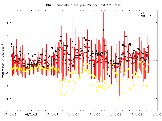
-
October Discussion: Bring the Frost-Hold the Snow
ORH_wxman replied to 40/70 Benchmark's topic in New England
ORH only got down to 31F during that October stretch, so I don't think BOS was wrong in 2009. We know both BOS and ORH don't radiate, so if ORH only managed 31F, then BOS didn't get below freezing. -
October Discussion: Bring the Frost-Hold the Snow
ORH_wxman replied to 40/70 Benchmark's topic in New England
The whole point of the shield and fans is to remove that bias. ASOS temps are taken in the shade too...the thermometer is inside a little box. The entire bias will never be totally removed because the ambient air is probably affected too much by the sun hitting darker surfaces near the ASOS, but it shouldn't be more than a degree or so even taking that into account if it is properly sited away from the pavement. -
EPS are starting to show it too near the end of the run...you can see how the N PAC is definitely shuffling. It could be rushed, but I'm leaning toward the change....it fits a lot of La Nina climo anyway.
-
October Discussion: Bring the Frost-Hold the Snow
ORH_wxman replied to 40/70 Benchmark's topic in New England
Latest 32F by station: BOS: 12/6 (2009) ORH: 11/12 (1977) BDL: 11/11 (1920) PVD: 11/19 (1935) -
October Discussion: Bring the Frost-Hold the Snow
ORH_wxman replied to 40/70 Benchmark's topic in New England
Do you mean 36F? Official frosts are not tracked...they use 36F as the marker, but we all know 36F comes in many different flavors and many won't produce frost. Freeze is a lot easier...it's just first date of 32F