ORH_wxman
-
Posts
93,099 -
Joined
-
Last visited
Content Type
Profiles
Blogs
Forums
American Weather
Media Demo
Store
Gallery
Everything posted by ORH_wxman
-
September Discussion Thread: Bring the frost; kill the bugs.
ORH_wxman replied to moneypitmike's topic in New England
2000-2009 had some frigid Octobers. 2007 was a huge notable exception but we had some brutally cold ones mixed in there. Of course, we already discussed the plethora of snow events during those years in October. -
We’ve increased another 70k or so since this and now we’re about 190k above the 9/1 minimum. We’re gonna need to see a big drop in the next couple days or I think we’ve reached the area minimum. We’re still losing extent right now. NSIDC is down another 40k to 4.77 million sq km.
-
September Discussion Thread: Bring the frost; kill the bugs.
ORH_wxman replied to moneypitmike's topic in New England
It’s kind of like getting a big cold outbreak in mid-March. If your high temp is like 24F, it’s cold but it just doesn’t match the bite it would a month earlier with the increasing sun angle. You get Tip’s warm car seats even though the actual pattern might resemble January or early February. I say it most years, but I love the torch patterns from about mid-September to late October. Just give me one really good cold shot in there to kill the bugs but otherwise, bring on the 70s/low 80s. -
Don't forget the big storm right before the blizzard. Jan 3-4, 1996....12"+ for a pretty solid area....basically north of a PVD-BDL line (sleet issues to the south). Frigid airmass at the surface in that one. The vortex behind that storm is what set the stage for the pre-blizzard airmass which was even colder. (even DC spent much of the '96 blizzard in the teens) http://www.meteo.psu.edu/fxg1/NARR/1996/us0103.php http://www.meteo.psu.edu/fxg1/NARR/1996/us0104.php
-
Yeah and the storm wasn't even a hugger....really bizarre how so much of SNE got dryslotted. Like you look at the upper air and it doesn't look remotely like that type of storm. I remmeber the south shore got stuck an OES band during that dryslot though and I was jealous of them. A few places got like 12-14" on the south shore while outside the band had like 7-8".
-
Yes...seems like 80% of the storms overachieved. Only other pseudo-disappointment that season was 2/16/96....where that band rotated into the berskhires and dryslotted a bunch of us. But even that storm was ofrecasted to be a whiff like 3 days out, so it was great that we were even getting one.
-
It was kind of a bust but still a big storm. We had about 9-10 inches back in ORH. About 6" from the initial storm and then another 3" from the vortmax "backlash" the next day....then another inch or so from the wrap-around ULL snowshowers that lasted like 3 days after it got stalled up in the Maritimes. I think the phase of the PV lobe was a little bit sloppy. Loop these two: http://www.meteo.psu.edu/fxg1/NARR/1995/us1219.php http://www.meteo.psu.edu/fxg1/NARR/1995/us1220.php You can see how the sfc low kind of escapes northeast a bit before that really good vortmax in the 2nd link catches up with it. It was originally forecasted to stall or at least slow down further southwest. The south shore did very well though because they were getting great OES contribution during the whole event with NE winds over the December still-mild waters. I think South Weymouth had like 20"+. But outside of the OES spots, it was a mild disappointment even though it was still a good storm in an absolute sense. It was the expectations that sort of ruined it. We had the rare "Blizzard Watch" about 36-48 hours before the storm....but never got converted to blizzard warning.
-
The NAO was a huge player in December...it migrated northward toward Greenland at times some but was very potent. It helped both the 12/14 clipper and the 12/19-20 storm stay cold/snowy. If you look at both of those setups, you'd see how they would be rainers without the -NAO. The 12/19 event had the block extending back down toward Hudson bay.
-
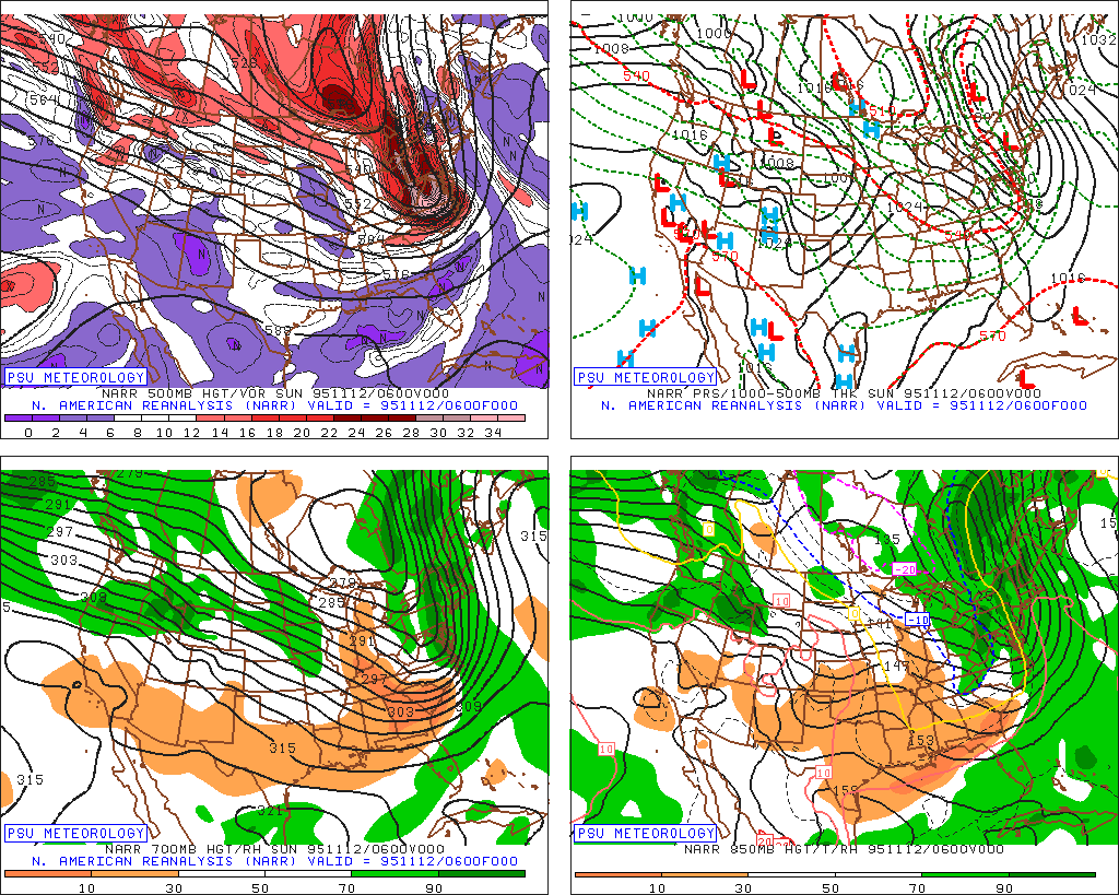
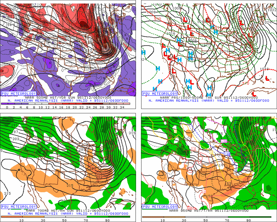
It looks like Nov 12, 1995 was a cheap midnight high...here is the 06z map....
-
Jan 1996 slightly exceeded 2011 in ORH....mostly because we jackpotted in the Jan 12th storm while the CP had mixing issues. I think we had about 43" at the peak in 1996 while 2011 had 39-40". Feb 2015 slightly beat that at 44". But both fell just a bit short of March 2001.
-
I do remember how early people were skating on ponds that season. It was like right after T-day in early December you would see people all over the ice. Typically you wouldn't see that until at least closer to Xmas and often later. But I can see why in looking at the F6 data....ORH hit 61 on November 12th....then would only see 50F one more rtime (on 11/28 but with a low below freezing). They then hit 42F on December 4th....they wouldn't sniff 40F again until January 17th which began the meltdown. It's very hard to go that long in December without hitting 40F but that year did it.
-
1995-1996 without the epic 2-3 week meltdown in 2nd half of January would be an amazing spectacle. The warmth in October 1995 abruptly flipping to very cold late that month was eerily prophetic. It never flipped back until the thaw in mid/late January.
-
A relatively snowless Feb 15-Mar 15 period is by far the worst. Way too early to think about actually doing much non-winter activities outside (unless you golf on the Cape or something)....and the snowpack just wilts in the sun. That happened last year in the final week of February and first week of March....we had like a 20"+ pack after 2/19 that just rotted and slowly sublimated/melted. Painful and boring as hell...especially knowing that you can get some absolute monster storms during that period.
-
There were some pretty good events in late February (2/25-26 and 2/27, then icing on 2/28) but they were admittedly more interior and N of pike.
-
Area increased 45k to put us about 120k above the 9/1 min. Still too close to call the min, but another 100k or so increase over the next 3 days would probably do it.
-
1992 had one on 8/31. This is for area though...not extent. Other early area minimums: 1983 9/2 1987 9/2 1988 9/3 2000 9/3 2005 9/3 (this used to be 8/30 until a recent revision put it at 9/3) 2019 9/4 (barely beat out 8/24 which would have been an unprecedented early minimum) My guess is we sneak below the 9/1 figure in 2021....we've had a bunch of other years that had a strung-out double-dip which it looked like an initial minimum had been achieved either in very late August or the few couple days of September only to have it dip again sometime between 9/8-9/14 or something. But we'll see. Each day that it stays above the 9/1 value, the more likely it is to hold up.
-
Yeah there is no way to defend that Euro forecast last September....it was horrendous. The only consolation was that basically zero seasonal models were able to pick up that type of Atlantic blocking.
-
Totally whiffed on the all the NAO/AO blocking up north....we never really got a SE ridge either.
-
Last year was mostly stale airmasses and we had that weird Nino-esque pattern for a while. OF course the one time we got a legit arctic airmass, that zone just N of the pike got the mini-screwjie in the Dec 17th storm. But yeah, if this is going to be more of a gradient pattern that is classic for La Nina, then it would be surprising to see another southern seasonal jackpot.
-
Often can be the case when there is a strong cold source just to the north. But it doesn't always happen within New England itself. Saw it in the '93-'94 winter where the best snowfall anomalies were prob along and just south of the pike into N CT/RI and SE MA. Though things would likely be shifted a little north if another '94 pattern happened today given that we were still in a post-Pinatubo world back then with an obscenely crushing Arctic PV.
-
February 1981 might one of the ugliest patterns you'll ever see for winter wx across the CONUS.
-
We may have reached the area minimum on 9/1....we're currently about 75k above the 9/1 value of 3.19 million sq km. Still a bit too precarious to call it, but if we had a 9/1 area min, that would be the earliest min since 1992.
-
Frigid December look. Torch February though there would be some cold lurking close on that.
-
September Discussion Thread: Bring the frost; kill the bugs.
ORH_wxman replied to moneypitmike's topic in New England
Yeah I'm sure it is different up there. For ORH, after that 1960s blitz, they had a total of 2 measurable October snowfalls between 1964-1999. Then starting in 2000, they had 8 events (1 in 2000, 1 in 2002, 1 in 2003, 2 in 2009, 2 in 2011, and 1 in 2020)....and probably had one in 2005 that got measured as a trace, but that could have happened in previous years too so I won't count it. -
Yeah the ECMWF seasonal look has a frigid Canada and we rarely get skunked when there's ample cold to tap into there. One of the few exceptions might be 1988-1989.