ORH_wxman
-
Posts
93,099 -
Joined
-
Last visited
Content Type
Profiles
Blogs
Forums
American Weather
Media Demo
Store
Gallery
Everything posted by ORH_wxman
-
DotRat's 401K is melting down!!!!
-
As with most housing, they got semi-affordable in the 2011-2013 time range near the bottom in real estate post-recession. We went up there and noticed a lot of pretty nice lakefront homes on sale for less than 500k....many under 400k. I'm not talking those 5-6 bedroom monstrosities right on Rangeley Lake...but like your typical 2 or 3 bed camps. There were probably a lot of families dumping their vacation homes because of the recession crunch. A lot of those same ones we saw are prob like 600-800k now.
-
You prob average near 50 there but you got porked last year plenty of times. There’s some seasons that you will clean up on Cape Anne.
-
What about Feb 2015? I think the max at ORH was 34F that month. I would have assumed Farmington didn’t break freezing but I guess they snuck above. Ditto January 2003 which had a max of like 37F or 38F.
-
I think it bottomed out at 952mb near CLE.
-
It was definitely a more traditional front-loaded Nina that finished with a wimper, but the first half was pretty damned good. January had no torches at all for those who like the prolonged snowpack getting deeper and deeper during the coldest climo days of winter.
-
Real estate agents just want some inventory to sell....we've gotten cold calls too. Because so little is on the market right now, they don't get their commissions. As for the more ambitious developers, they just want the land. They can buy a little ranch for 500-600k in a nice town, level it, and rebuild a McMansion for 200k and then resell the thing at 1.1 million easily after being all-in at 700-800k.
-
Yeah that was a pretty uniformly good season across most of New England. There weren't any extreme jackpot zones and few true screw zones. CT Valley may have been a little on the light side and maybe the outer Cape was struggling to reach average, but otherwise hard to find any spots below average.
-
Yeah I make that comment to my wife when we are shocked at how much our house has appreciated in value since we bought it in early 2017. I say "We could sell and pocket hundreds of thousands of dollars....but then we'd have to overpay for an even more expensive house".....lol. I guess we could make a killing if we just sold and moved to Rumford Maine or something.
-
As soon as he moves back south of Methuen, he's going to get porked by a 3/4-6/01 storm where Methuen gets 30" and he gets 18-20".
-
That is bizarre....they wouldn't take a check from a credit union and get a car off their lot? Sounds like posturing to me.
-
There's definitely some that are overreacting to it. It's unfortunate when it affects everyone else.
-
Weak front went through last night which probably helped.
-
I said this weeks ago....but.....none of the delta covid "breakthrough" talk is compelling when it's not killing or hospitalizing vaccinated people. It's just not really a story if vaxxed people test positive but aren't getting any serious symptoms.
-
Ray is going to watch like 3 Weymouth jacks this winter on OES enhancement in frigid airmasses.
-
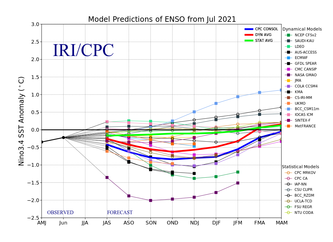
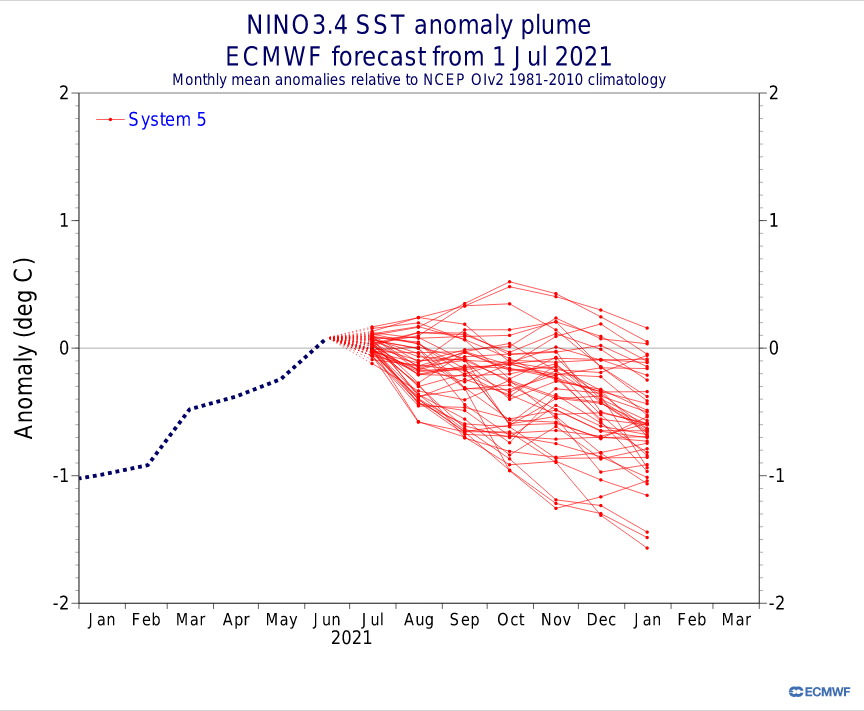
Weak cold neutral would be fine too....both cold neutral and weak La Nina are favorable states for New England. I have a gut feeling we'll see the return of cold SWFEs this winter...ENSO state sort of supports it, but we're due for a frigid Canada after a couple of torch winters to our north.
-
Weak La Nina is definitely gaining steam in the model guidance

-
We're only superficially close on 2012 extent...NSIDC has us only 10k more, but JAXA and UBremen have us over 500,000 sqkm behind and we're also trailing 2012 by over 500,000 sqkm in area. NSIDC extent will eventually start lagging 2012 significantly. We won't finish close to 2012 given the current numbers. The ice is actually very compact right now which is not what you want to see when you are looking for a huge cliff in the coming weeks.
-
That dominant vortex on the asian side draws warmer air in from the Siberian mainland. You can see it show up well on the anomalies so far this summer. A reverse dipole like 2013 would have kept it colder.
-
This summer's pressure pattern isn't nearly as favorable for ice retention as the classic reverse dipole retention seasons (like 1996, 2006, or even 2013)....the core of the low pressure anomalies were on the North American side of the pole in those years whereas this year it's up on the Asian side in the Laptev/adjacent CAB. That's going to advect some milder air in at times from Siberia. It's still a lot better than last year though.
-
For the whole month, yes...but I think the first 13 days of 2009 were definitely colder than the first 13 of 2021.
-
Yeah I’m def more for the chill/relaxed vibe. We spend most of the week on the lake in Maine and usually bring the kids to storyland one day and that’s also when we stop in N Conway afterward on the way back.
-
My wife loves the general store there. We usually stop in once during our week-long vacation 30 minutes away in Maine. It’s a fun town to go into for an afternoon or maybe an evening for dinner, but I kind of side with Phin on not wanting to be there a long time. I start to get claustrophobic with some of the tourist crowds after a while. N Conway does have some sweet views though just walking around there.
-
Man, ORH running a -4.3 departure through 13 days this month. Not 2009 levels but still pretty cold compared to recent years.
-
I went to the Red Sox game the other day and took the green line from Riverside...I feel like about 20-25% weren’t wearing masks but nobody was enforcing it. My guess is they will probably drop the requirements in another month or two assuming there isn’t a big resurgence here.