ORH_wxman
-
Posts
93,092 -
Joined
-
Last visited
Content Type
Profiles
Blogs
Forums
American Weather
Media Demo
Store
Gallery
Everything posted by ORH_wxman
-
I dunno, it's gonna pop quick when that trailing s/w catches up.
-
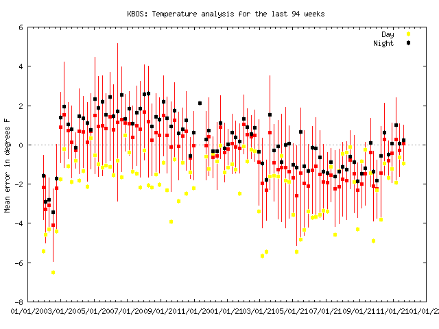
It's definitely weird that BOS actually got colder in November averages compared to 30 years ago. But looking at the decadal numbers, it makes sense...one of those flukes. The cold Novembers in the 2010s did it.
-
BOS January 1961-1990: 28.6 BOS January 1991-2020: 29.9 ORH January 1961-1990: 22.8 ORH January 1991-2020: 24.7 November was by far the lowest change...which is interesting. Anecdotelly I would've thought November would be the worst, though it's probably being blunted by some epically cold Novembers we've had recently (like 2018 and 2019)...and the 1980s did not have cold Novembers...the only one that was more than like -1 was 1989. January is kind of in between December and November for the amount of rise.
-
Trading 1989 for 2015 alone adds almost a full degree to the 30 year average for December in ORH.
-
BOS November 1961-1990: 45.3 BOS November 1991-2020: 44.7 (!!!) ORH November 1961-1990: 39.4 ORH November 1991-2020: 40.2 BOS December 1961-1990: 33.6 BOS December 1991-2020: 35.7 ORH December 1961-1990: 27.4 ORH December 1991-2020: 30.5 ORH really got nuked in December..BOS did too but not as much....losing 1989 and gaining 2015 is a big one though.
-
It'll definitely be less at non-radiator spots. Radiational cooling has been the biggest casualty of CC.
-
Yes Hudson Bay is lagging badly....the arctic ocean though and adjacent seas are way ahead of recent years. Hudson Bay had no ice at this point in 2016, 2012, 2010, 2006, and 2003 too, so while rare, it isn't unheard of.
-
Those of us along the pike are always conflicted...
-
EPS was a bit paltry on the Sunday/Monday system last night. Would like to see it come back on board a bit more. But there’s still plenty of time.
-
Haven't fired up the heated sidewalks yet? My monitor is saved from a high-impact event for another day.
-
Chukchi sea froze over faster than any year since after the 2012 monster melt. The difference is 2021 also has refrozen on the Atlantic side very fast unlike that 2012 autumn. That's why we're more like the early 2000s right now for extent
-
You realize that it's like 5-6 days out still, right? This isn't a 3 day lead time right now. It's fine to point out the possibility (hell, I linked to my post 4 days ago pointing out the favorability of the pattern for Nov 28-30), but "locking" it in is ridiculous.
-
He cant help himself....man, even 2014 Kevin wasn't this bipolar.
-
That is interesting....KBOS went to crap in the spring too after last winter. You can see when they fixed the REALLY bad issues back in spring of 2020, but then the step down to crappy (but not quite as bad as before) in spring 2021 and now getting back to normal in fall 2021
-
December 2021 Obs/Disco...Dreaming of a White-Weenie Xmas
ORH_wxman replied to 40/70 Benchmark's topic in New England
EPS basically cancelled it too...maybe a brief torch around D10. -
Actually pretty decent mean for 6 days out...has measurable snowfall for most of the area.
-
Not the final solution of course....that was close to something a lot better. Verbatim though, prob just some light snow mostly S of pike on that run for Sunday.
-
Euro is going to have snow here on Sunday...possibly into Monday too...backside energy trying to dive in so we'll see if it goes to town, but even the current solution has light snow falling on Sunday in SNE.
-
PRob going to be getting good upslope snows on Friday too...even over at BW. This looks like a pretty robust event because there's a lot of deeper level synoptic moisture associated with it.
-
December 2021 Obs/Disco...Dreaming of a White-Weenie Xmas
ORH_wxman replied to 40/70 Benchmark's topic in New England
GEFS actually cancels any torch at all....just reloads the cold before the mild air ever has a chance to make it into New England. -
Ukie with a little nuke next Monday. Canadian trying too....GFS not interested.
-
December 2021 Obs/Disco...Dreaming of a White-Weenie Xmas
ORH_wxman replied to 40/70 Benchmark's topic in New England
Yeah we know the caveats. Guidance has been volatile so nothing is locked. -
December 2021 Obs/Disco...Dreaming of a White-Weenie Xmas
ORH_wxman replied to 40/70 Benchmark's topic in New England
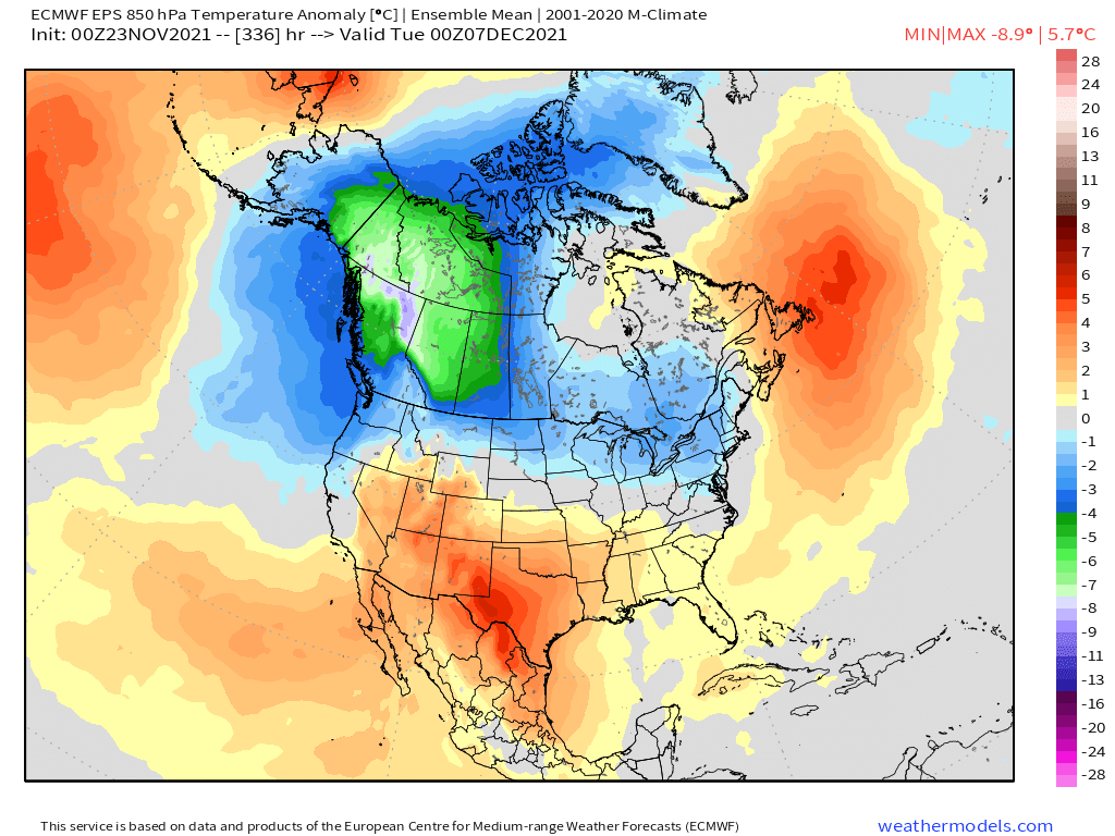
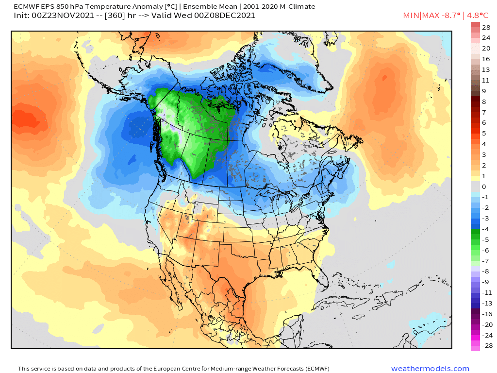
Pretty classic “good La Niña” look on that run where the N tier gets cold and active storm track. You can see the gradient there on the 850 temp anomalies (and it’s easy to see at H5 too). That’s definitely what we are hoping for. It helps that the Atlantic isn’t horrific...almost kind of neutral look there. PV also displaced a little south toward our side of the pole.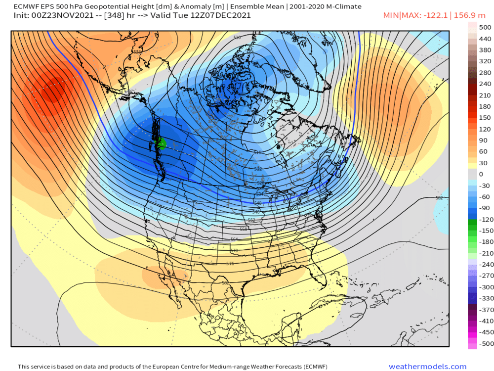
-
I’d be surprised if we don’t at least get the “first flakes” monkey off our back for many of the areas who haven’t seen them yet. Prob a lot of popcorn snow showers around with that upper level cold pool even if we don’t get a real storm.
-
December 2021 Obs/Disco...Dreaming of a White-Weenie Xmas
ORH_wxman replied to 40/70 Benchmark's topic in New England
EPS looked really solid last night. We’ll take this for sure....