

ORH_wxman
-
Posts
93,095 -
Joined
-
Last visited
Content Type
Profiles
Blogs
Forums
American Weather
Media Demo
Store
Gallery
Everything posted by ORH_wxman
-
Monitoring a potential important TV to East Coastal storm: Jan 17
ORH_wxman replied to Typhoon Tip's topic in New England
NAM def colder than 12z....but 12z was an epic torch....18z is just merely a torch. Still warmer than the global guidance despite being colder than its own 12z run. -
Monitoring a potential important TV to East Coastal storm: Jan 17
ORH_wxman replied to Typhoon Tip's topic in New England
It might be too generous if some of these solutions that have the ML warmth in here almost at go-time end up being more correct. But he could also get 5-6" if things break right. -
Yeah, that's the whole "She's not gonna let us out" joke....we want to just let it go but this winter won't let us. Showing a totally loaded pattern going forward so it makes it hard to just punt. I think she just wants to torture us....
-
EPS likes 3 different windows....first one was Jan 22-23....second is Jan 27ish....and last is Jan 29. But in all honesty, any of the dates between about Jan 21 and the end of the run are primed. It was just focusing on those ones where we see a mean low pressure near the BM or just to our east.
-
1980s we’re a decent decade for the midatlantic too. So then getting h it a few times definitely fits the 80s theme.
-
Monitoring a potential important TV to East Coastal storm: Jan 17
ORH_wxman replied to Typhoon Tip's topic in New England
As soon as the rest of us move to the shoreline. -
Monitoring a potential important TV to East Coastal storm: Jan 17
ORH_wxman replied to Typhoon Tip's topic in New England
Yeah the NARCAN maps are likely better in this situation. -
Monitoring a potential important TV to East Coastal storm: Jan 17
ORH_wxman replied to Typhoon Tip's topic in New England
Yeah it looked a little less crazy amped at H5....but small differences. The small difference do matter, but it's hard to tell if they are real when they are small. Could be model noise. Hopefully we get another couple ticks colder and it would vastly improve the overall tenure of the storm. -
Monitoring a potential important TV to East Coastal storm: Jan 17
ORH_wxman replied to Typhoon Tip's topic in New England
The precision at which we get porked in this storm against a plethora of snow-bound analogs is pretty funny though…in a masochistic sort of way. I have done this for 3 days now, but yet, I’m still shocked every time I look at the 4-panel map 24 hours prior to this storm hitting and say “this is going to be mostly a rain event”. It’s amazing. You’d think there was no way. Sure, we’ve had 0F to 45F rainers 12 hours later before but you could easily see it coming when you viewed the maps. This time, it’s not obvious at all until you get to lime T-12 hours or so. Truly surgical precision of getting shafted out of a MECS/HECS type storm. -
Monitoring a potential important TV to East Coastal storm: Jan 17
ORH_wxman replied to Typhoon Tip's topic in New England
Yeah we'll see...maybe that shortwave comes in weaker. I am admittedly going on anecdotal evidence. Maybe @OceanStWx has some insight onto the statistics of incoming shortwaves recently...if they've been stronger or weaker after being sampled. -
Monitoring a potential important TV to East Coastal storm: Jan 17
ORH_wxman replied to Typhoon Tip's topic in New England
Yeah if there is a "colder" bust with this system as it pertains to sensible wx, I think the most likely scenario is that model guidance ends up too eager to erode the arctic airmass. I'm skeptical of any large scale changes aloft...in fact, I'm actually expecting that last northern stream piece to come in even stronger when sampled since that often seems to be the case, but we'll see. No guarantees in this business. However, if model guidance does a semi-poor job at resolving this lower level arctic airmass, then it could be too aggressive pushing that 805-925 warmth into here, so I'm open to the idea that we end up a bit snowier because of that.....but I'm putting that scenario as still unlikely. -
Monitoring a potential important TV to East Coastal storm: Jan 17
ORH_wxman replied to Typhoon Tip's topic in New England
Maybe we can blow Scooter's roof off on the GFS? Nice little mesolow over E MA. -
Monitoring a potential important TV to East Coastal storm: Jan 17
ORH_wxman replied to Typhoon Tip's topic in New England
It's negligible....the SSTs that is. SSTs aren't the reason this is over BGM instead of the Cape. -
Monitoring a potential important TV to East Coastal storm: Jan 17
ORH_wxman replied to Typhoon Tip's topic in New England
Yeah well said....It's amazing that not a SINGLE analog is as far west as the current storm on guidance....but guidance is in such good agreement, you can't go against it at this lead time. -
Monitoring a potential important TV to East Coastal storm: Jan 17
ORH_wxman replied to Typhoon Tip's topic in New England
Here's your NAM clown map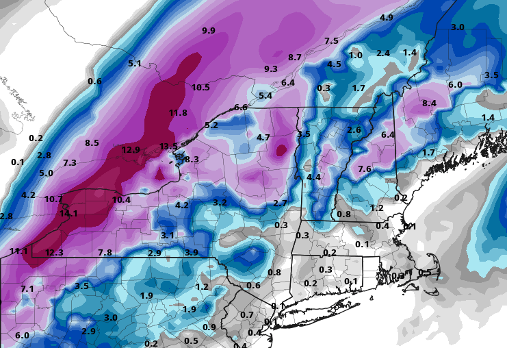
-
Monitoring a potential important TV to East Coastal storm: Jan 17
ORH_wxman replied to Typhoon Tip's topic in New England
Yeah we get a literal perfect storm of shortwave phasing to send it due north (or even NNW) when even a 010 or 020 vector would be fine. Funny how every single CIPS analog does not go as far west as this one does. -
Monitoring a potential important TV to East Coastal storm: Jan 17
ORH_wxman replied to Typhoon Tip's topic in New England
BGM track at the sfc on the NAM -
Monitoring a potential important TV to East Coastal storm: Jan 17
ORH_wxman replied to Typhoon Tip's topic in New England
NAM coming in warmer than it's already previously torched solution. -
Monitoring a potential important TV to East Coastal storm: Jan 17
ORH_wxman replied to Typhoon Tip's topic in New England
Yeah there may be a frozen glacier at the end....but meh. If it's not at least 5-6", it kind of sucks at this point. If we get a 6+ thump, I'm all for it....but my worry is we get about 2" before the flip which is useless. I don't see this trending back east aloft enough to matter....but stranger things have happened. This winter finds new ways to disappoint... Probably one of the most incredible storm evolutions I've ever seen. Every single CIPS analog for that ULL position down south has us either getting big snow or some of them actually fringe us....not s single one rips the storm to our west (at least aloft), yet this time, it is going to achieve that. If you showed me this below map at 24 hours before the storm begins and told me we'd get drenched with rain from an inland runner, I'd think you were on drugs....lol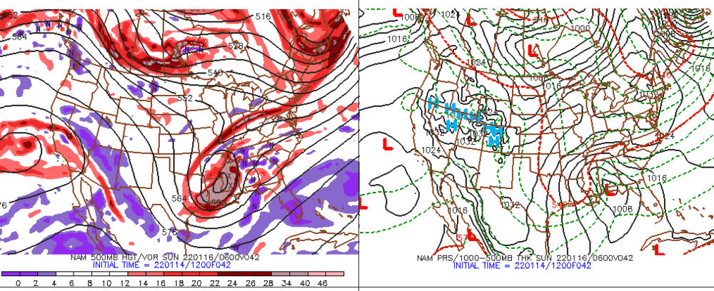
-
Monitoring a potential important TV to East Coastal storm: Jan 17
ORH_wxman replied to Typhoon Tip's topic in New England
I do expect the interior to stay wedged....the question is whether it's mostly just ORH county and Berks or if most of SNE away from the coast stays wedged. Won't be much pack to protect though unless we can keep the mid-level warmth at bay for several hours during the heavy stuff. -
Monitoring a potential important TV to East Coastal storm: Jan 17
ORH_wxman replied to Typhoon Tip's topic in New England
Your area is the most uncertain IMHO....I could see you getting 8-10" but I could also see you only getting 2-4" if this mid-level warm creep continues on guidance for another couple of cycles. -
Monitoring a potential important TV to East Coastal storm: Jan 17
ORH_wxman replied to Typhoon Tip's topic in New England
I was giving it until about 72 hours lead time…we’ve now gotten there and guidance is locked and loaded. If anything, I actually expect this to warm/amp up a bit more as we often see in southern stream systems…we’ll get that warm trend until maybe 24h out and then a little messenger shuffle. NAM is hinting at the mid-level warmth the most but I wouldn’t discount it just because it’s the NAM. Synoptically it makes sense. Hopefully we get an east tick, but how often do we see those with southern stream juicers? -
Monitoring a potential important TV to East Coastal storm: Jan 17
ORH_wxman replied to Typhoon Tip's topic in New England
Yeah it looks fine for NNE and N berks. It’s dogshit for most of SNE unless we get a meaningful shift…which still may happen but I’m skeptical given the very good model consistency. -
Monitoring a potential important TV to East Coastal storm: Jan 17
ORH_wxman replied to Typhoon Tip's topic in New England
Won’t help us aloft. Might keep the sfc colder in the 30s during the rain a d maybe produce some ZR far enough interior like N ORH county. Otherwise, no real effect in terms of snowfall. We’d need the redevelopment to happen in the midlevels for it to matter on snow. -
Monitoring a potential important TV to East Coastal storm: Jan 17
ORH_wxman replied to Typhoon Tip's topic in New England
Nothing left to really track with this one down here. Model guidance looks locked in. If we see a move, I’ll become more invested again, but right now it’s just whack-a-mole. I’m expecting maybe 2-3” and then a gully washer. I think 6+ is reserved for N ORH county and Berkshires.


