

ORH_wxman
-
Posts
93,095 -
Joined
-
Last visited
Content Type
Profiles
Blogs
Forums
American Weather
Media Demo
Store
Gallery
Everything posted by ORH_wxman
-
It's a defense mechanism for many on here to whine. The GFS actually improved a little for 1/22 even though it still misses. Bit I do think the 1/24 threat has more room to work with even though there are still some minor spacing issues with the 1/22 wave ahead of it.
-
Yeah I get the sentiment....but it seems like Thursday is starting to ramp up....but if we can phase in more SW energy, then it won't matter as much being a detriment to 1/22. We can get both that way....the western variables are more important.
-
Biggest change on the NAM was phasing in more southwest energy into the shortwave around the MS river valley.
-
Yeah those changes out west overwhelmed the changes in the east. Those will be the bigger factors, but all else equal, I still don't want to amp up 1/20. However, we deserve to be greedy and get both with the way this season has gone.
-
It is not the only factor....we can definitely get both events, but all else equal, we'd rather not have this one. There are other factors this run that are helping out 1/22 that are independent of the frontal wave.
-
Trough was shifted a lot westward this run which is good. Northern stream diving in behind it was much further west. Those are very good changes.
-
NAM def coming in more amped. I'd want to see Euro get on board though before actually taking it seriously. The more amped this one is, the less likely 1/22 is IMHO.
-
EPS looks a touch SE of 18z but definitely still pretty decent for SNE
-
Yeah goes without saying. It was torching the first week of February a few cycles ago and now it’s showing cold to start February.
-
I actually thought 18z looked a little better too. Guess we’ll see if other guidance starts to play ball at 00z or if the euro starts to cave, but 18z was a solid double down by the Euro.
-
I’d say more like through the first week of February and then they furnace most of the CONUS east of the Rockies.
-
I’m not totally down and out. Just being realistic on the likelihood of these. 1/22 has a real chance but I don’t think people should be getting confident on the Euro solution yet. 1/24 looks worse right now but who knows how it might look of 1/22 evaporates…it would likely look a bit better. The longwave pattern beyond continues to look very good so I can’t punt winter yet even if these don’t work out.
-
That was quite the brain buster
-
Lol, I don’t know about “constantly”…but just taking a quick look at guidance would show the EPS/Euro are moderately enthused by 1/22 while most other guidance doesn’t like either storm very much. GFS sort of likes 1/24 but never really committing to a big solution there and maybe the GGEM is starting to come around on 1/22. Add it all up and maybe 1/22 has a decent shot (say something between 25-50%) and 1/24 is a long shot (say 10-20%).
-
Yes and I actually think that’s favored right now. Though not by a lot.
-
Yes it will. In order to get it, we need the front side of the trough to sharpen up and that will push the baroclinic zone down south offshore further in its wake. We don’t want that for Saturday.
-
Gonna have to shovel the top of the driveway in the next hour. The last remnants of slush from the plow didn’t melt like I hoped it would (I cleared the rest of the driveway earlier).
-
I don’t think both 1/22 and 1/24 work. It’s going to be one or the other like Tip said. There’s additional threats after that timeframe around 1/25-1/27 timeframe but they are different from the 1/22-1/24 threats.
-
Yeah that one is a fraud. Better off anyway not ripping the baroclinic zone to Bermuda to ruin Saturday.
-
Yeah trying to pull a mini-version what just happened only further east. I still want to see more guidance on board.
-
No we got the other thread for that one.
-
Pretty classic clipper/redeveloper look on euro for 1/25. It would be nice to grab a couple good and clean (no mix crap) events over the next 10 days to change the tenure of the season.
-
It’ll nail that but then puke on itself for 1/22. Start blasting White Snake.
-
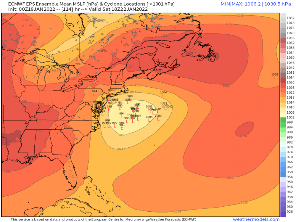
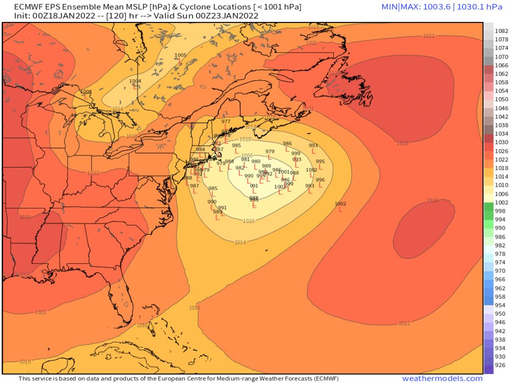
Yeah I’m pretty skeptical of this 1/22 storm right now. Euro basically on its own here. In the past, I’d really give it a lot more respect because it’s nailed storms so many times at D5 while being on an island by itself but it hasn’t done that too much in the past 2-3 seasons. Still, it’s the best model so can’t totally discount it. I’m sure the EPS will like it since they weren’t bad at 06z either.
-
That gets kicked east really fast. Hopefully it comes in more amped on future runs because that’s a tight squeeze…red flags there.


