ORH_wxman
-
Posts
93,095 -
Joined
-
Last visited
Content Type
Profiles
Blogs
Forums
American Weather
Media Demo
Store
Gallery
Everything posted by ORH_wxman
-
Gotta watch for a little fluff tonight too.
-
3/26/14 was that obscene bomb. The Cape did get into part of the CCB but not the heart of it so they picked up like 8-12 instead of feet. They had some legit blizzard conditions though.
-
Cris Collinsworth feeling like he’s 25 again tonight.
-
Solid underrated post here
-
EPS are in the game still.
-
Yeah that winter was never salvaged on the coastal plain. Even the interior didn’t fully make it up in SNE but we did have a good Feb/Mar. In ORH, I had 5” on 1/31….lol. Finished the season at 49.7 so I did make a solid comeback but it wasn’t enough to dig out of such a deep hole.
-
It would honestly be pretty hilarious if after all the whining everyone did, we get hit with back to back monsters 3 days apart.
-
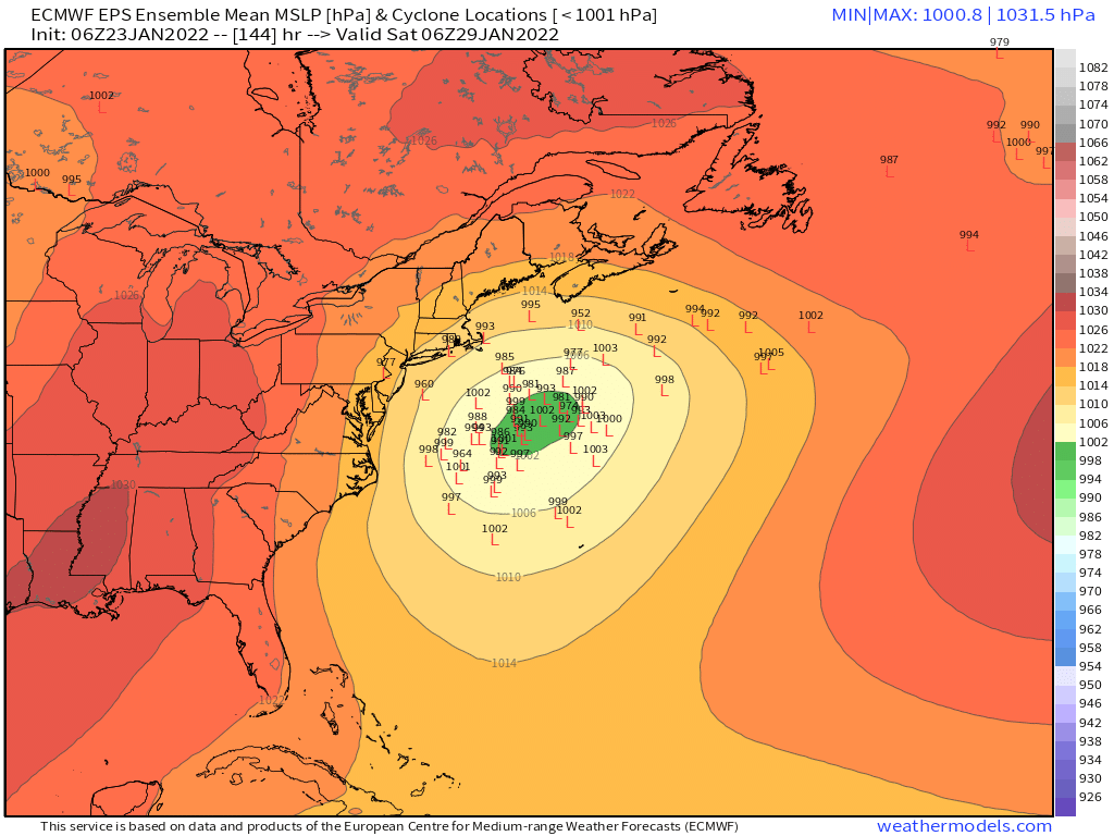
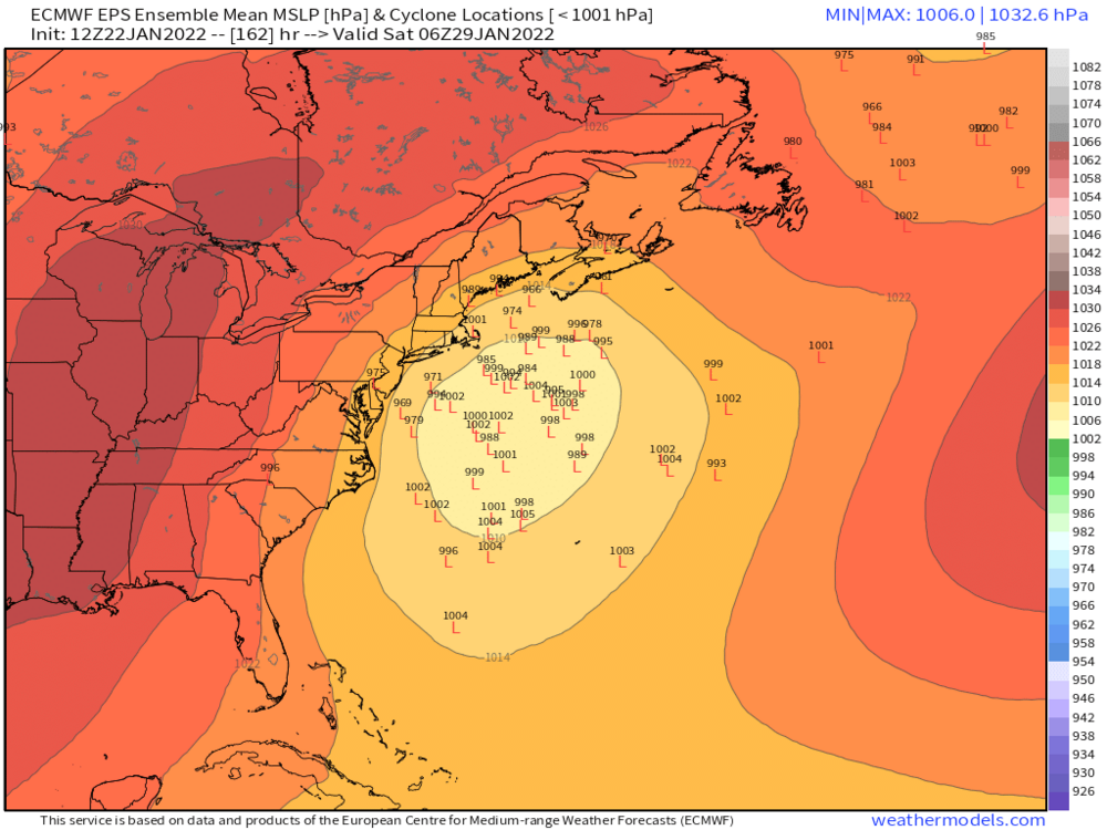
KU brewing there at d9-10
-
Euro is prob gonna try and cook up another monster at D9-10 too. The follow up wave that the GFS has shown.
-
White Snake 1980s winter. Hopefully it turns around like some of those 2010s winters did. I guess the gold standard for turnaround winters in your backyard is 2006-2007…though that was a Nino.
-
It actually comes close enough to get some light snow. But nuisance stuff.
-
Euro is gonna be wide right for 1/29. But it’s got the trough there in a decent spot for D7. Looked promising at 138-144 but the northern stream just didn’t quite buy in enough. But that’s close.
-
Yeah if we get 1-2 on Tuesday I’ll consider it a win. Once we lost the southern stream it went to garbage.
-
Ukie looks like it would be a hit or at least close. Doesn’t bury the energy like GGEM or GFS.
-
GGEM buries energy southwest too for the D7 system but the northern stream causes a moderate event.
-
There’s two systems. D7 wide right this run and D9 is a hit. Both could miss but you really can’t ask for a lot more given the lead time.
-
Other guidance is mostly trash for Tuesday. Not biting on anything more than 1-2” yet. Would be nice to grab a bigger event but the other guidance doesn’t like the southern stream much anymore. Maybe we’ll get a shift back at 12z.
-
MWN employees cry at the claims of real cold by fake radiators. MWN lives being erased.
-
Please do explain more
-
Pretty rare to get air masses that don’t mix cold down unless it’s maybe spring time with sun and you get extra diabetic heating that is far more than winter. I’d call that fake warmth…like in March when when you have -2C 850 temps and sun the day before a big storm hits….you hit 52F but then when precip starts it’s in the upper 20th r lower 30s.
-
Semantics. Not representative of the vertical airmass like a well mixed surface is.
-
It’s kind of fake in that it goes away as soon as you mix out. Like many spots around here that were below zero will crack 20F today. There’s definitely a difference in radiaitonal cold vs advected deep cold. Yeah, pipes and cars still have problems but other things like wind chill and rate of daytime warming are vastly different.
-
We have something a little “heavier” than flurries. It’s steady very light snow call it. It looks nice because of the perfect fat aggregates but it doesnt really add up to anything unless it does this for hours and hours.
-
Yes. This is all in the lowest 3000-4000 feet.