ORH_wxman
-
Posts
93,095 -
Joined
-
Last visited
Content Type
Profiles
Blogs
Forums
American Weather
Media Demo
Store
Gallery
Everything posted by ORH_wxman
-
Yeah NAM is the last holdout.
-
Getting some really nice fatties right now…just massive clumped dendrite aggregates
-
Actually I’ll take that back…euro/NAM have trended south enough with northern stream that they do drop 1-2”…guess we’ll see if that can stick. But the southern stream idea seems to be going away.
-
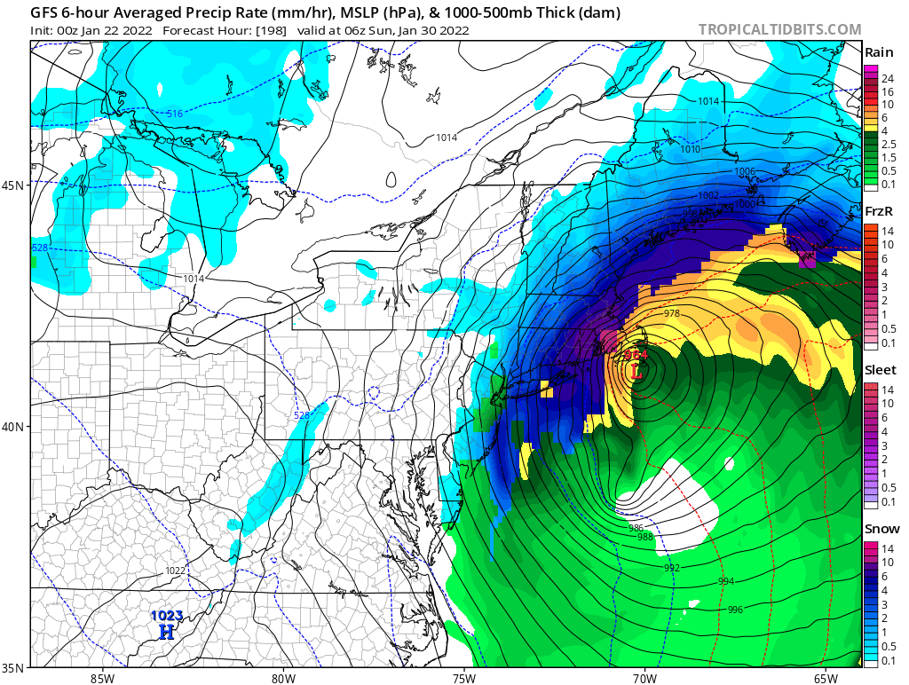
Tuesday went to zilch on most guidance. Too bad. Was hoping that one could squeeze out an advisory event. Guess we wait and see if 1/29-30 will pan out.
-
Lol

-
18z GFS was run out of the EMA super weenie computer.
-
18z GFS looking healthier for Tuesday. Hopefully we can all bow to Rev Kev’s 4-8” when the time comes. I’m still skeptical but I’ve been keeping an eye on that southern stream.
-
I likely avg around 65 here...and I'm around 15 so far. 50" is a heavy lift from here on out. Not impossible but unlikely.
-
You have a much better chance to reach normal than I do (I already specifically mentioned that CT has a better shot)....you already have more snow than me on the year and your climo is lower. For a place like here that barely has 15" and needs another 50 to reach climo is much bleaker....it's possible, but odds are stacked against it.
-
Yeah for all intents and purposes, '78 was a Miller B...there's really no binary answer on most of these because we are able to observe a fart swirl in the low levels a lot better than we did back in the 1940s when the designations came out in the Miller paper. I would say Feb '13 was more of a hybrid than '78 was...but both were very northern stream dominant which is why they went insane on SNE. You could say the same thing for January 12, 2011 too. Like, technically there's a swirl down off FL as the storm approaches from the west, but do we really care that much when the dominant low is in the OH valley at first? That's kind of the distinction Miller made in his paper too....talking about a dominant low inland in the OH valley yielding to cyclogenesis on the east coast. I think that's really the spirit of the definition. Anyways, enough of the semantics before I derail the thread further.
-
Yeah I was slow-rolling the description there for a D8-9 threat. It is actually a very good signal for that far out....but I didn't want to start hyping too much. We know how different this could look tomorrow or the next day.
-
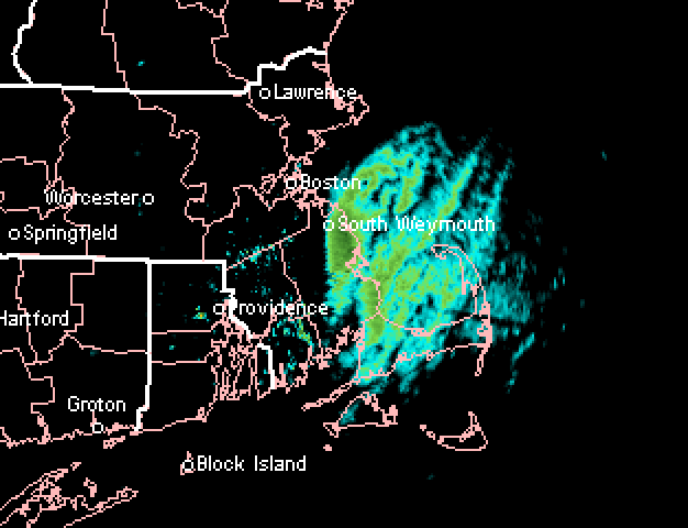
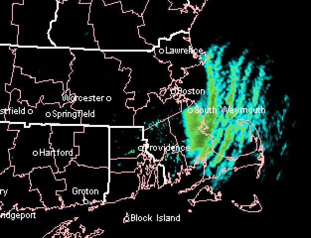
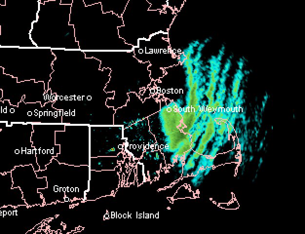
Awesome streamer...hitting Marshfield harder too than before:
-
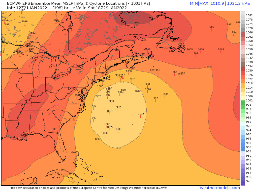
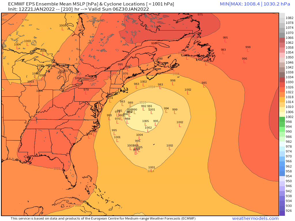
Anyways, I've seen worse EPS runs than this at 8-9 days out....it's an eternity, but at least there is some cross-guidance support on this one.
-
Dude, once we whiffed on the last 3 threats, our fate was mostly sealed for a below average snowfall winter.....sure, we could rebound, but it's very unlikely at this point where we are. Areas further southwest in CT that have gotten a little more plus a lower snowfall climo to begin with have an easier path to getting to normal snowfall.
-
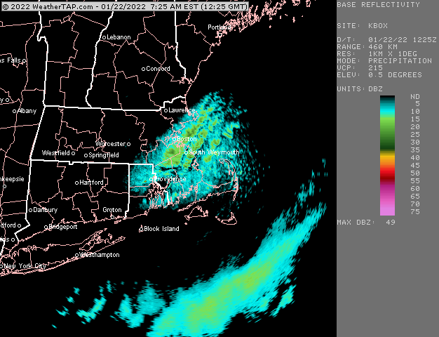
Yeah that was funny to me....Kevin does a rare map post and he decides to do it for an image that shows a light band of snow showers.
-
That looks pretty epic.
-
Yeah I think the key is not having it bury itself so far south....but there is a lot of time for that to change. When I look at the D7 map at H5, there's some pretty good potential to make that a big system for us without screwing around for another 48 hours.
-
Lol, I feel like that probably won't verify...that is actually a lot warmer than last Monday's storm.
-
We are gonna need that northern stream to draw it north.
-
i've always loved the snowfalls where you can look up and see the shadowed aggregate clumps against the white sky. That pic has it to the extreme....very large aggregate clumps....likely hooked dendrites of course given the BL temps in the snow growth zone. Probably 20 or 25 to 1 fluffer nutter.
-
This looks like a different system....that's 264 hours and the system we're tracking is more like 192-216ish.
-
You might end up with 6"+ by the time we get to tomorrow lunchtime. It'll be interesting to track but theoretically it might be even better OES late tonight and early tomorrow....but these are often very quirky as I"m sure you are aware. This is a really impressive streamer though that has set up over PYM county.
-
I'm not expecting much from it, but there were two sort of "interesting" potentials with that one....the first potential was solely northern stream giving us a NJ-model redeveloper....that idea went out the window a few cycles ago when the northern stream trended too far north. A second emerging "interesting" scenario started showing up when that energy in the southwest got ejected and rides around the base of the northern stream giving the system new life for something bigger than a 1-3" nuisance event. I think the southern stream scenario is tougher because it requires both good timing and also having the southern stream maintain its integrity long enough before getting ground up by the geopotential gradient.....but the GGEM shows how its done. Ukie was fairly close but the shortwave weakened a little too quickly.
-
Someone further northeast must have 4"+ by now...that band is just hammering Kingston/Duxbury/far northern PYM.
-
Yes, you can get on board with that southern wave and ditch the moose farts for this one. This one can snow decently for most of the forum. They'll be plenty of other chances for moose flatulence.