ORH_wxman
-
Posts
93,095 -
Joined
-
Last visited
Content Type
Profiles
Blogs
Forums
American Weather
Media Demo
Store
Gallery
Everything posted by ORH_wxman
-
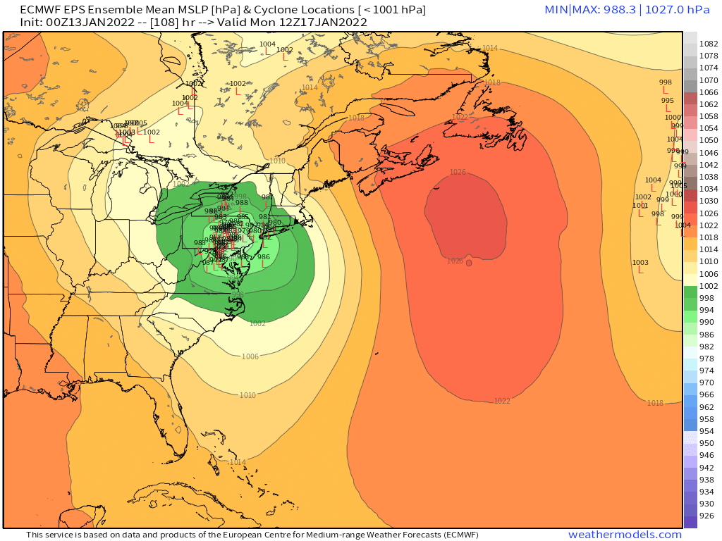
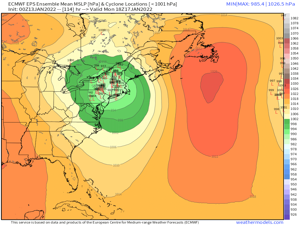
Monitoring a potential important TV to East Coastal storm: Jan 17
ORH_wxman replied to Typhoon Tip's topic in New England
Yeah it kind of starts compressing those lows as they gain latitude....we want to see those compressed and elongating more E-W....if H5 starts elongating E-W, then it will try and produce a redeveloping ML center to the east. Even if the eastern ML center doesn't become dominant before reaching us, just having it develop will help a lot as it will slow down the WAA. -
Monitoring a potential important TV to East Coastal storm: Jan 17
ORH_wxman replied to Typhoon Tip's topic in New England
If we can have that southern stream bulge out to the east a bit, we can prob redevelop a mid-level center. You can almost see this happening on the GFS at 96 hours....look at that kink in the 700mb heights and how it's even seen a little bit at H5....if we can have that poking east just a bit even if the actual H5 center is further west, then that would help a lot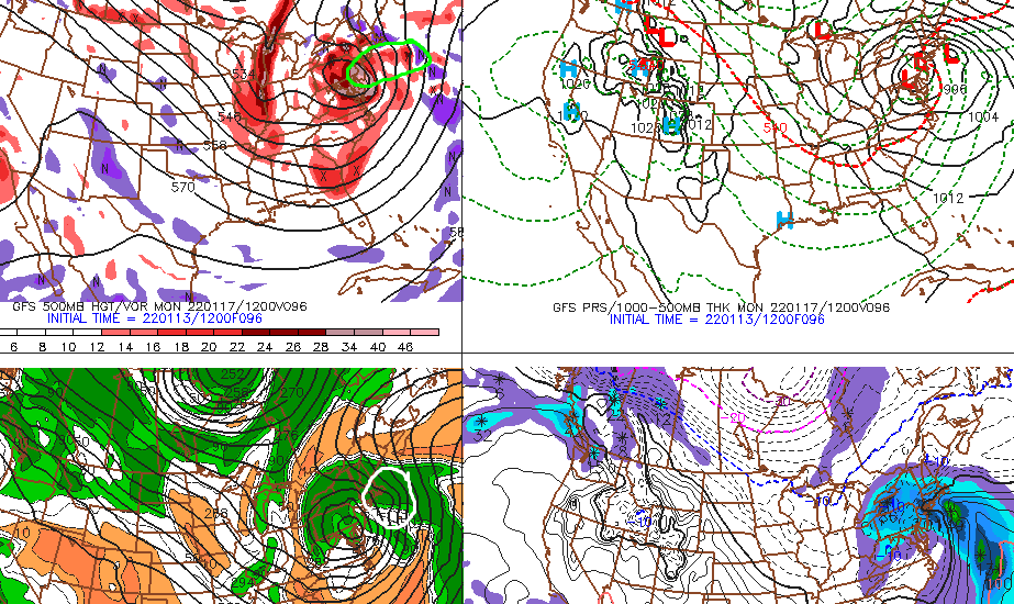
-
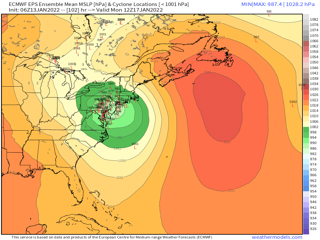
Monitoring a potential important TV to East Coastal storm: Jan 17
ORH_wxman replied to Typhoon Tip's topic in New England
That's essentially a wash with 06z GFS....there are some really minor differences, but not worth getting out an electron microscope to analyze a 90-96 hour solution. We had counter-acting trends on that run aloft...we had better confluence holding to out north and east, but the southern shortwave was a tad slower that run which allowed it to amplify and "Catch up" to the 06z run later on...I think some spots further south were a little colder this run too, but again, small differences. -
Monitoring a potential important TV to East Coastal storm: Jan 17
ORH_wxman replied to Typhoon Tip's topic in New England
Only potential "negative" is the southern stream is a tick slower....so that could cause it to make up ground a bit later...but the heights are definitely noticeably lower over NE, so I think that hopefully ends up causing a less amped solution. -
Monitoring a potential important TV to East Coastal storm: Jan 17
ORH_wxman replied to Typhoon Tip's topic in New England
GFS looks a bit more suppressed than 06z on the heights out ahead of it at 48 hours. -
Monitoring a potential important TV to East Coastal storm: Jan 17
ORH_wxman replied to Typhoon Tip's topic in New England
NY State...even if this ticks east some it will be in NY State probably....since the western solutions are in SE Ontario to near MSS....lol. -
Monitoring a potential important TV to East Coastal storm: Jan 17
ORH_wxman replied to Typhoon Tip's topic in New England
It's the NAM, but I'm only looking at 54 hours (not 84) and the northern stream shortwave is a lot weaker this run and the Friday system is hanging back quite a bit while the southern stream is digging a bit more south....I think this would create a better slingshot solution for NE. -
Monitoring a potential important TV to East Coastal storm: Jan 17
ORH_wxman replied to Typhoon Tip's topic in New England
Yeah prob more like 8-12 then a slot. But if we can nudge this east enough to get the low over the Cape, then we could see some amounts marginally over 12"....kind of like March 2017...I think I had 13-14" in that one before getting slotted. On the flip side, we can prob sell amounts over 8" if something closer to the Euro happens. -
Monitoring a potential important TV to East Coastal storm: Jan 17
ORH_wxman replied to Typhoon Tip's topic in New England
He needs a few events from '07-'08 to take me to the shed. -
Yeah the midlevels actually look decent and not a total Bruce Willis job. I think that would actually argue for more precip west....but I'd want to see some other guidance nudge like the NAM before getting too invested.
-
If we can get that band back to here, we'd prob pick up a couple inches. It's just about here on the 12z NAM.
-
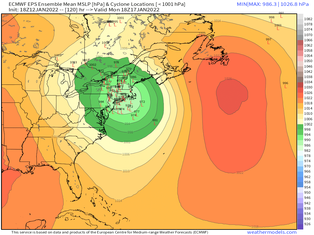
Monitoring a potential important TV to East Coastal storm: Jan 17
ORH_wxman replied to Typhoon Tip's topic in New England
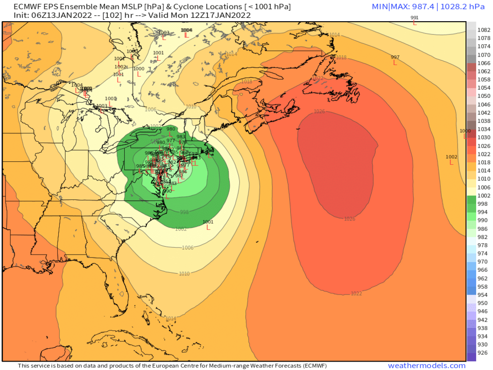
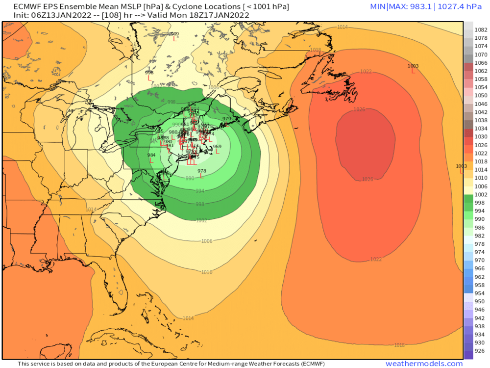
You can see how the 06z run has come back east a good tick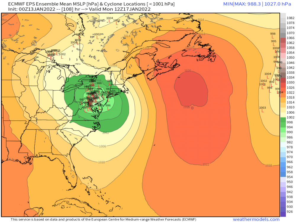

-
Monitoring a potential important TV to East Coastal storm: Jan 17
ORH_wxman replied to Typhoon Tip's topic in New England
EPS coming back east some too. -
Monitoring a potential important TV to East Coastal storm: Jan 17
ORH_wxman replied to Typhoon Tip's topic in New England
GFS was def better at 06z. Need to see the euro come back east some. -
Monitoring a potential important TV to East Coastal storm: Jan 17
ORH_wxman replied to Typhoon Tip's topic in New England
I just got up to look, but EPS looked west. Like way west. Not a single member is southeast of us now
-
Monitoring a potential important TV to East Coastal storm: Jan 17
ORH_wxman replied to Typhoon Tip's topic in New England
Rgem doesn’t go out far enough but the Friday storm hangs back this run and the southern shortwave sped up vs 18z. So that combo would def make it eastward. We’ll see if those are real trends or just false flags by the JV team. -
Monitoring a potential important TV to East Coastal storm: Jan 17
ORH_wxman replied to Typhoon Tip's topic in New England
Icon will be east of 18z. Still waiting for the useful models to come out. -
Monitoring a potential important TV to East Coastal storm: Jan 17
ORH_wxman replied to Typhoon Tip's topic in New England
Yeah I’d agree with that. The spread looks like it’s larger on the 18z run. -
Monitoring a potential important TV to East Coastal storm: Jan 17
ORH_wxman replied to Typhoon Tip's topic in New England
18z EPS actually looks a bit west of the 12z run. I’m on my phone so can’t really toggle but eyeball glance looks west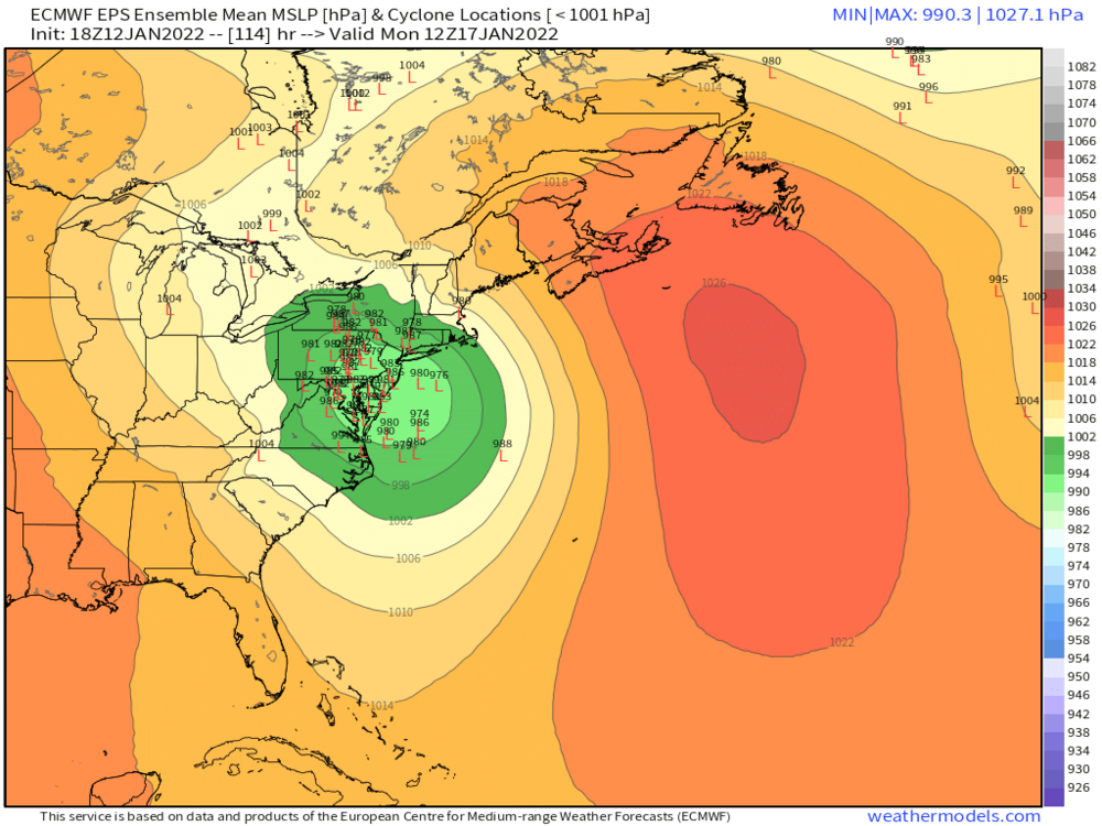

-
Monitoring a potential important TV to East Coastal storm: Jan 17
ORH_wxman replied to Typhoon Tip's topic in New England
It had the same trend as the 18z GFS with lower heights out ahead of it over New England. I think that would help the front end even if it tries to track west. -
Monitoring a potential important TV to East Coastal storm: Jan 17
ORH_wxman replied to Typhoon Tip's topic in New England
I don’t know if it’s more likely…it’s close enough for me not to be the arbiter of which one stays and which one goes. There’s definitely a western limit to this and BUF may be near that limit. There’s more room on the eastern side than on the western side…the skew won’t be a normal/Gaussian distribution. -
Monitoring a potential important TV to East Coastal storm: Jan 17
ORH_wxman replied to Typhoon Tip's topic in New England
We’d have to throw out the ones over BUF too if we did that. -
Monitoring a potential important TV to East Coastal storm: Jan 17
ORH_wxman replied to Typhoon Tip's topic in New England
It’s not super far from being a 12/16/07 type coastal. If you recall, that was originally supposed to track into BUF but the high got better and eventually we got a triple point over SE MA…and of course the big snow thump. -
Monitoring a potential important TV to East Coastal storm: Jan 17
ORH_wxman replied to Typhoon Tip's topic in New England
One reason to remain somewhat optimistic for more snow is that the antecedent airmass is strong, so if that high holds on just a shade longer, you prob get disproportional return on the snowfall in the positive direction. You can even see it on the some of the ensemble members. Some of the ones that hold onto the high just a smidge more thump 8-12" in a pretty large area over SNE.