

ORH_wxman
-
Posts
93,092 -
Joined
-
Last visited
Content Type
Profiles
Blogs
Forums
American Weather
Media Demo
Store
Gallery
Everything posted by ORH_wxman
-
March 12 Rain to…more rain? Maybe some snow
ORH_wxman replied to HoarfrostHubb's topic in New England
It’s actually ripping in this band. Less than half mile vis.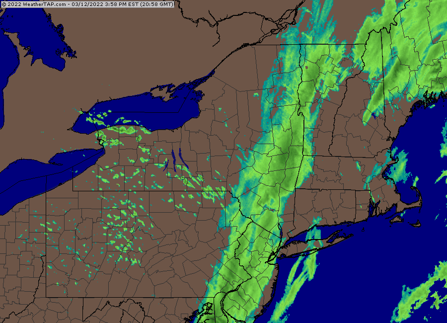
-
March 2022 Obs/Disc: In Like a Lamb, Out Like a Butterfly
ORH_wxman replied to 40/70 Benchmark's topic in New England
Pattern gets kind of slow and blocky…not really huge arctic blocking per say, but bowling ball season with pseudo blocks in Canada…Tip alluded to this the other day. But this is showing up pretty strong on all ensemble guidance is we head into the equinox and beyond during the final week of March. So while we prance in the tulips a couple times next week, there’s a reasonable chance we haven’t seen our last accumulating snow…esp for interior. -
March 12 Rain to…more rain? Maybe some snow
ORH_wxman replied to HoarfrostHubb's topic in New England
There will be another band of light snow later but the heavy stuff is done. -
March 12 Rain to…more rain? Maybe some snow
ORH_wxman replied to HoarfrostHubb's topic in New England
Yeah I mentioned that earlier too. Prob not very heavy but could be a steady light to occasionally moderate snow late afternoon into early evening. -
March 12 Rain to…more rain? Maybe some snow
ORH_wxman replied to HoarfrostHubb's topic in New England
Yeah not impressed with radar down south. The changeover seems a bit faster than modeled but that is coming at the price of precip starting to shred quicker. -
March 12 Rain to…more rain? Maybe some snow
ORH_wxman replied to HoarfrostHubb's topic in New England
Mix line just about to ORH.
-
March 12 Rain to…more rain? Maybe some snow
ORH_wxman replied to HoarfrostHubb's topic in New England
That’s a good sign. You might be able to pull a 6+ spot. -
March 12 Rain to…more rain? Maybe some snow
ORH_wxman replied to HoarfrostHubb's topic in New England
12z NAM looks super torchy and northwest. Hard to buy it though because it looks pretty bad down to the southwest. It has almost no snow it spots that are already flipping. -
March 12 Rain to…more rain? Maybe some snow
ORH_wxman replied to HoarfrostHubb's topic in New England
No there will be accumulations. Just not sure if it will be more than an inch or two. I guess we’ll just see how quickly it can flip. -
March 12 Rain to…more rain? Maybe some snow
ORH_wxman replied to HoarfrostHubb's topic in New England
NW CT and Berkshires are def gonna get hit really good. You can see it setting up really well for them. I wonder if near Danbury and Waterbury could be a sneaky good place. Esp areas above 500 feet. I wouldn’t be shocked to see solid advisory amounts there. Further southeast is a question mark. -
March 12 Rain to…more rain? Maybe some snow
ORH_wxman replied to HoarfrostHubb's topic in New England
Yeah we fight the dry air below 850. There could be a little burst close to 00z as the upper trough gets closer but otherwise I’m pretty meh on this for advisory snow or greater. I think there’s going to be a lot of 1-3” type amounts. -
March 12 Rain to…more rain? Maybe some snow
ORH_wxman replied to HoarfrostHubb's topic in New England
12z HRRR not impressed with SNE outside of Berkshires and NW CT. -
March 12 Rain to…more rain? Maybe some snow
ORH_wxman replied to HoarfrostHubb's topic in New England
Close call there. But I think hedging lower is the way to go on this one. Usually the west slopes of the Berkshires and NW CT are gonna clean up in a setup like this while out east the northwesterly flow starts drying out the atmosphere. So it becomes a race. -
March 12 Rain to…more rain? Maybe some snow
ORH_wxman replied to HoarfrostHubb's topic in New England
Prob would’ve been Dec 10, 2008 -
March 12 Rain to…more rain? Maybe some snow
ORH_wxman replied to HoarfrostHubb's topic in New England
Yep. These are the events Kevin can get terrain enhancement on. He needs a westerly component or a southerly component where he is. -
March 12 Rain to…more rain? Maybe some snow
ORH_wxman replied to HoarfrostHubb's topic in New England
Kuchera (not posting 10 to 1 in this)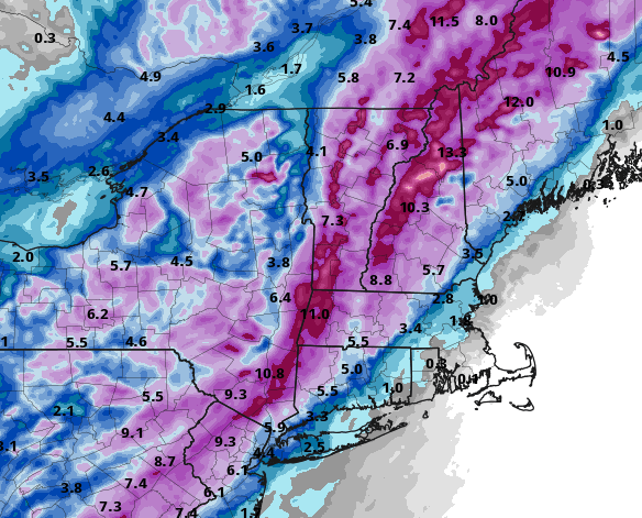
-
March 12 Rain to…more rain? Maybe some snow
ORH_wxman replied to HoarfrostHubb's topic in New England
3km is actually snowier for SNE and more potent with the dynamics than 12z. -
March 12 Rain to…more rain? Maybe some snow
ORH_wxman replied to HoarfrostHubb's topic in New England
Yeah the dynamics look much better on that run....hopefully it plays out with stronger dynamics. Weak and strung out it not going to be as fun....even if it might get 1.5" of slush on the weak scenario versus 0.7" on the stronger scenario. -
March 12 Rain to…more rain? Maybe some snow
ORH_wxman replied to HoarfrostHubb's topic in New England
18z NAM going west a solid tick. -
March 12 Rain to…more rain? Maybe some snow
ORH_wxman replied to HoarfrostHubb's topic in New England
Yes, and then a week later there was a marginal 8-10" storm for north of the pike....basically a front ender at 32-33F isothermal sounding. That was poorly forecasted. -
March 12 Rain to…more rain? Maybe some snow
ORH_wxman replied to HoarfrostHubb's topic in New England
There will be some good precip rates, but duration is an issue. This thing will be screaming northeast. -
March 12 Rain to…more rain? Maybe some snow
ORH_wxman replied to HoarfrostHubb's topic in New England
Around here I only really want to see about -5C or so which the top of the saturated layer achieves (at least on the western half of the sleet band)....there's so much salt nuclei in SNE sticking out into the ocean that the baseline numbers get skewed warmer for ice crystals. That said, my guess is the HRRR is too cold anyway, so it's prob a moot point.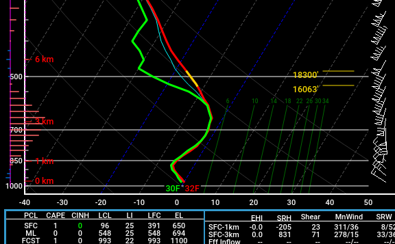
-
March 12 Rain to…more rain? Maybe some snow
ORH_wxman replied to HoarfrostHubb's topic in New England
Pivotal is probably too wide with the sleet ptype looking at the soundings. Like it's showing sleet where the entire column is colder than -2C but because it's not saturated in the DGZ, it shows up as sleet. -
March 12 Rain to…more rain? Maybe some snow
ORH_wxman replied to HoarfrostHubb's topic in New England
There was 1-2" in the interior on 3/3 -
March 12 Rain to…more rain? Maybe some snow
ORH_wxman replied to HoarfrostHubb's topic in New England
For us, yes....out west though it's been a much bigger differences on some of these runs.

