

ORH_wxman
-
Posts
93,095 -
Joined
-
Last visited
Content Type
Profiles
Blogs
Forums
American Weather
Media Demo
Store
Gallery
Everything posted by ORH_wxman
-
Preliminarily ... a medium impact partial Miller B, Friday
ORH_wxman replied to Typhoon Tip's topic in New England
One thing I noticed on the Euro is that the vort max we see on most other guidance on the front side of the trough is a lot weaker. I wonder if that is playing a role...generally weaker dynamics (and weaker height falls)? See below....here's the GFS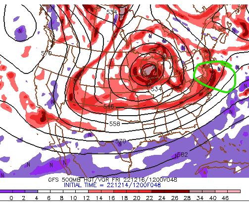
-
Preliminarily ... a medium impact partial Miller B, Friday
ORH_wxman replied to Typhoon Tip's topic in New England
Even the stubborn ones eventually submit to the power of the interior hills on 925 tracks over the Cape. It's just a matter of time....tick tock. The only way out of embarrassment is to trend it back NW. -
Preliminarily ... a medium impact partial Miller B, Friday
ORH_wxman replied to Typhoon Tip's topic in New England
Tossed further than Ray's Xmas presents. -
Preliminarily ... a medium impact partial Miller B, Friday
ORH_wxman replied to Typhoon Tip's topic in New England
No, too warm at 925.....but my guess is in reality there could be. The clown maps are going to be wrong for a chunk of high terrain on the eastern edge of our hills IMHO if you are tracking 925 low over the Cape. -
Preliminarily ... a medium impact partial Miller B, Friday
ORH_wxman replied to Typhoon Tip's topic in New England
I think it's def too warm at 925 with that track.....but we'll have to wait until Friday to know for sure assuming the track is similar to reality. -
Preliminarily ... a medium impact partial Miller B, Friday
ORH_wxman replied to Typhoon Tip's topic in New England
Looks like it goes right over the Cape -
Preliminarily ... a medium impact partial Miller B, Friday
ORH_wxman replied to Typhoon Tip's topic in New England
Yep, def started SE, and then it hooked....it's def the most NW model now of all the major guidance. -
Preliminarily ... a medium impact partial Miller B, Friday
ORH_wxman replied to Typhoon Tip's topic in New England
Euro looking a bit SE through 36h. -
Preliminarily ... a medium impact partial Miller B, Friday
ORH_wxman replied to Typhoon Tip's topic in New England
GFS still might be too far south but there’s no doubt other guidance has trended hard towards it. -
Preliminarily ... a medium impact partial Miller B, Friday
ORH_wxman replied to Typhoon Tip's topic in New England
Here's an example on GFS....this is 06z Saturday (late Fri night)....look where the 850 low is here at this point...its still down by Islands so you are getting great easterly inflow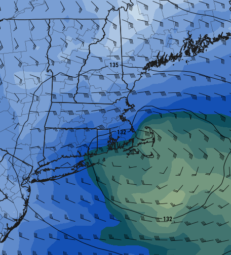
-
Preliminarily ... a medium impact partial Miller B, Friday
ORH_wxman replied to Typhoon Tip's topic in New England
There are rules for "Wrap around" working out....the biggest rule is keeping the ML centers to your south....very hard to do good wrap around when you are ripping 850mb out of the NW or even NNW which tends to dry out the atmosphere. You want it still coming out the NE to give good moisture advection. The runs that give good CCB wrap around are doing that....GFS/Ukie....even RGEM though RGEM was a little more precarious. PRob better up by Ray's hood on RGEM wraparound. -
Preliminarily ... a medium impact partial Miller B, Friday
ORH_wxman replied to Typhoon Tip's topic in New England
06z to 12z looked the most intense. It does linger into Sat PM though on that run.... -
Preliminarily ... a medium impact partial Miller B, Friday
ORH_wxman replied to Typhoon Tip's topic in New England
The track is almost perfect....850 stays below freezing for everyone N of MA/RI border now on the Ukie, but it's still trying to furnace 925 (but it cooled a decent amount there too versus prior runs) -
Preliminarily ... a medium impact partial Miller B, Friday
ORH_wxman replied to Typhoon Tip's topic in New England
Yeah it hammered most of E MA with big CCB overnight. Remains to be seen if that will materialize, but we follow. Ukie verbatim was pretty warm, but it's always warm in the low levels and it's been cooling as we get closer. The track is more important to me on that model and the track looks lot more like the GFS. -
Preliminarily ... a medium impact partial Miller B, Friday
ORH_wxman replied to Typhoon Tip's topic in New England
They also got stronger....which is what we want. You want to see this sfc low bomb out big time to collapse things SE as quickly as possible in the CCB stage -
Preliminarily ... a medium impact partial Miller B, Friday
ORH_wxman replied to Typhoon Tip's topic in New England
GEFS ticked SE again too....getting kind of close to use ensemble clusters, but with some uncertainty still remaining, I find it interesting. Every model is moving toward the GFS right now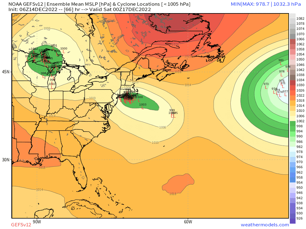
-
Preliminarily ... a medium impact partial Miller B, Friday
ORH_wxman replied to Typhoon Tip's topic in New England
Yeah kind of like '92-lite....we never got the big ULL underneath us, but a little part of it getting squeezed underneath gives us the mini-version perhaps. -
Preliminarily ... a medium impact partial Miller B, Friday
ORH_wxman replied to Typhoon Tip's topic in New England
Wow...Ukie went insane for eastern areas overnight Saturday....joining the GFS. -
Preliminarily ... a medium impact partial Miller B, Friday
ORH_wxman replied to Typhoon Tip's topic in New England
Models will under-do the snow in heavy lift...esp models that are hydrostatic. They kind of put an artificial cap on the dynamics. This is why we often see the model busts in those marginal events with very heavy precip....they can't quite capture the true dynamics going on. They are approximating it and the errors will become bigger the more dynamical a system is. That's why us mets have traditionally always said things like "if the dynamics are big, watch out....there could be surprises"......but it's hard to say when they will be that way versus more middling. -
Preliminarily ... a medium impact partial Miller B, Friday
ORH_wxman replied to Typhoon Tip's topic in New England
It almost certainly would flip right to the coast on that look....but again, big if. RGEM/GFS liked the idea....NAM didn't. We'll see if we can trend the Euro that direction today. -
Preliminarily ... a medium impact partial Miller B, Friday
ORH_wxman replied to Typhoon Tip's topic in New England
Yes. -
Preliminarily ... a medium impact partial Miller B, Friday
ORH_wxman replied to Typhoon Tip's topic in New England
20-burger in ORH county with that look....not forecasting that right now, but these slower "meandering eastward" type solutions have some pretty high positive bust potential in those areas...and maybe positive bust too for eastern MA coastal plain too if that collapse SE during CCB overnight Friday night happens....still a big if on that part. NAM didn't really show that, but GFS/RGEM did. -
Preliminarily ... a medium impact partial Miller B, Friday
ORH_wxman replied to Typhoon Tip's topic in New England
RGEM was showing it too. Those mid-level tracks are mouth-watering for elevated interior. -
Preliminarily ... a medium impact partial Miller B, Friday
ORH_wxman replied to Typhoon Tip's topic in New England
One thing I like seeing is heights are falling pretty quickly during this whole event. That is going to want to be trying to counter WAA more and more as the event goes on. -
Preliminarily ... a medium impact partial Miller B, Friday
ORH_wxman replied to Typhoon Tip's topic in New England
And scorpion bowls


