ORH_wxman
-
Posts
93,095 -
Joined
-
Last visited
Content Type
Profiles
Blogs
Forums
American Weather
Media Demo
Store
Gallery
Everything posted by ORH_wxman
-
Yeah the Euro was kind of a middle ground. My guess is it won't play out like that though....prob more binary. But well see. This pattern has been really screwing with guidance. They are having a lot of trouble handling the extreme blocking...it makes it hard to pinpoint which piece of energy get emphasized.
-
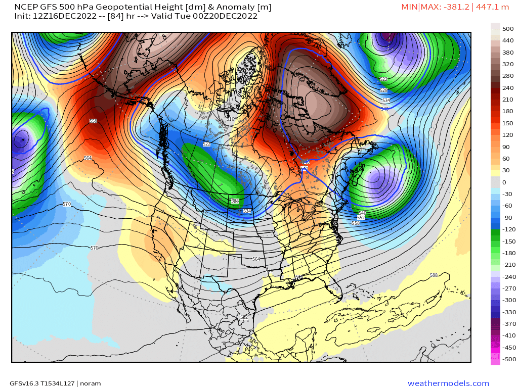
Well one of the sets of models will be wrong....so by deifnition one of them will change a lot. GFS and NAM are similar while GGEM/Ukie are in the other camp. You can see the PV diving SE on the GFS/NAM....here's a comparison between GFS and GEM at 84 hours....you can cleary see the GFS is already sending that piece of PV off to the east and southeast.
-
Ukie is the in the GEM boat right now....no PV moving east. Americans vs Foreign right now on the 12z suite pending the Euro.
-
Yeah, if the main shortwave behind that lead wave can catch up just a bit, then you end up with a really high end type system in NE. That's how Feb 2013 happened....there was this little lead wave around the Carolinas and the main shortwave caught it and phased.
-
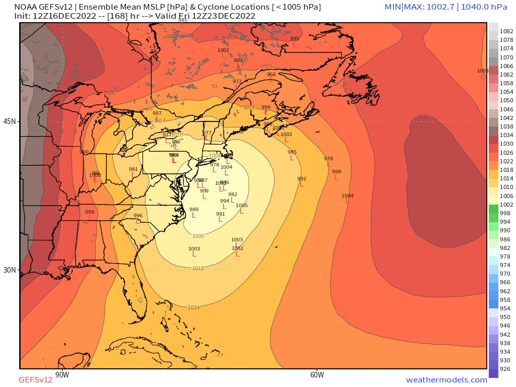
Preliminarily ... a medium impact partial Miller B, Friday
ORH_wxman replied to Typhoon Tip's topic in New England
This is the weirdest CF I've ever seen...it goes from like FIT to Barre to Belchertown and then almost due south to Enfield CT and then back SW to around Simsbury. The hi res models did do pretty well with this overall....they were too diffuse with the CF which made it hard to even see, but the overall low levels played out pretty close to what they were forecasting. -
Obv things will change, but just talking GFS, it would be nice if that whole thing came in about 200 miles shallower (further N)....I don't like seeing these stemwinder systems from the gulf....they typically don't end up that great here. They will often be snowy in an absolute sense but usually we get dryslot and/or some mixing issues.
-
PV never makes it eastward on the GEM....the whole thing happens pretty early in the run....like look at 84h at H5 on GEM vs GFS....GFS already diving the PV lobe ESE with some ridging on the west coast while GEM has no ridging there and the PV is just going to park in W Canada with nothing to pin it under the NAO block. FWIW, the NAM at 84h looks like the GFS and not the GEM.
-
Maybe because today's setup isn't a lakes cutter and there's no PV in western Canada today? Other than that, they look exactly the same.
-
Solutions like the GGEM are a complete synoptic change because it has no PV/PV lobe pinned in SE Canada....it just retrogrades it to western Canada opening the doors for a lakes cutter....so that pv is something to watch.
-
It's lazy attempt at trolling....esp since the setup on next week's storm doesn't really look anything like today's storm. If it somehow ends up similar, it would be out of sheer coincidence rather than some special forecasting skill by qg_omega.
-
PV lob is pinned further SE this run so that would reduce the chance of something looking cutterish
-
Preliminarily ... a medium impact partial Miller B, Friday
ORH_wxman replied to Typhoon Tip's topic in New England
Plan on nothing and if you get an inch or two, it will be a pleasant surprise. I don't like late tonight that much since the low is already lifting north....north of pike maybe slightly better shot since the flow is still more northerly rather than NW. -
Apparently enough people on here..... This morning is honestly some of the best entertainment I've seen on here. Just unhinged posters with zero ability to parse data in a logical manner. This is when I really wish we still had the weenie tags.
-
2/3rd are favorable. Hard to complain about those odds at D7.
-
Preliminarily ... a medium impact partial Miller B, Friday
ORH_wxman replied to Typhoon Tip's topic in New England
Looks like WaWa is getting crushed on their webcam -
Preliminarily ... a medium impact partial Miller B, Friday
ORH_wxman replied to Typhoon Tip's topic in New England
3k tracks over the Cape....it also brings a but more of a CCB early tomorrow. Not as good as Euro/GFS but might be an inch or two in spots. -
Preliminarily ... a medium impact partial Miller B, Friday
ORH_wxman replied to Typhoon Tip's topic in New England
Euro def had a nice CCB band curling down for late tonight/early tomorrow. But yeah, not really buying it yet because I'd like to see other guidance...esp mesoscales. GFS had it too at 06z. -
Preliminarily ... a medium impact partial Miller B, Friday
ORH_wxman replied to Typhoon Tip's topic in New England
You might get destroyed in the next few hours.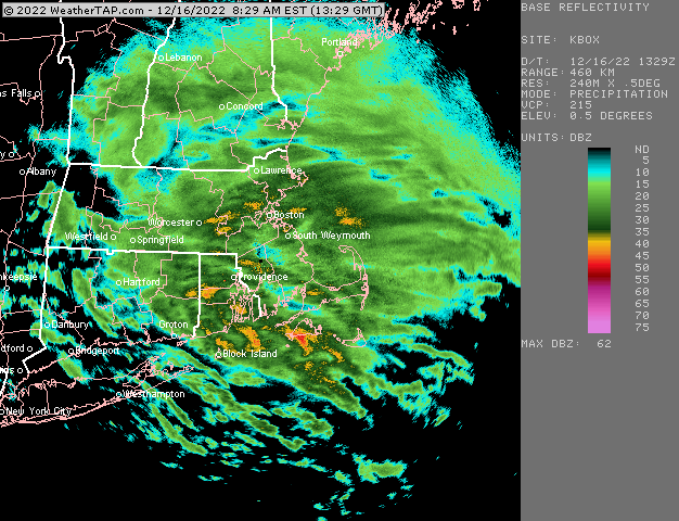
-
Preliminarily ... a medium impact partial Miller B, Friday
ORH_wxman replied to Typhoon Tip's topic in New England
Yeah flipped there about 30-40 min ago i think. Down to 32 quickly. -
Preliminarily ... a medium impact partial Miller B, Friday
ORH_wxman replied to Typhoon Tip's topic in New England
You will prob start parachuting soon if that front moves even another mile or two. -
Preliminarily ... a medium impact partial Miller B, Friday
ORH_wxman replied to Typhoon Tip's topic in New England
Lift was also kind of meh I think. I noticed how cellular and fragmented radar looked down there even predawn. But who knows if it would have mattered. There def seems to be a distinct boundary in N ORH county. -
Preliminarily ... a medium impact partial Miller B, Friday
ORH_wxman replied to Typhoon Tip's topic in New England
Front looks like its just south of rt 2 in ORH county. I’m surprised there’s like a 5-6F difference over a couple miles. I didn’t really see that on guidance. We’ll see if it sinks a bit more over the next couple hours.
-
Preliminarily ... a medium impact partial Miller B, Friday
ORH_wxman replied to Typhoon Tip's topic in New England
Rap has been hitting the snow hard for you. It has like 4 or 5” -
Preliminarily ... a medium impact partial Miller B, Friday
ORH_wxman replied to Typhoon Tip's topic in New England
The radar is going to look snowy for a long time because aloft supports snow until around midday there. It’ll lose the snow texture in CT a bit earlier but the problem in this event for a good chunk of it is low level temps and not aloft…much of the precip is done by the time 850-875 warm above freezing. The radar is shooting that beam a few thousand feet aloft by the time it reaches central areas.