ORH_wxman
-
Posts
93,095 -
Joined
-
Last visited
Content Type
Profiles
Blogs
Forums
American Weather
Media Demo
Store
Gallery
Everything posted by ORH_wxman
-
This is what guidance last week generally looked like prior to the end-of-week storm....you can see the PV lobe trapped in SE Canada just to our north. That's a cold look here. That obviously didn't materialize.
-
Here's 12 hours later....you can see a few members look good. But obviously still needs improvement
-
Some mild interest from the EPS
-
The narrative I think is set in stone unfortunately....there will be PTSD from this 3 year La Nina. The '07-'08s, '08-'09s, '10-'11s and '17-'18s of the world will be quickly forgotten next time a La Nina is coming.
-
Yeah that is working against the threat because it's de-amplifying the western ridge as the system approaches the east coast....you typically want the opposite where the western ridge is building. Now if it can trend to holding the line for another 12 hours, then I think we'd be in business.
-
Right....previous runs were just having the storm bully itself into the block and push it out eastward instead of positive feedback and pushing it west. The latter scenario makes more sense meteorologically....esp considering the heights are already quite high up there. That could also change some of the looks we see post-12/27 as a block around Hudson Bay will try and promote split flow.
-
Model guidance seems like it was way too fast breaking that block down during and just after the 12/23 event. Having it hang around gives another shot.
-
There's some potential for phasing too with that southern stream vortmax....so there's reason to watch this for a cycle or three provided the main northern stream shortwave keeps showing up strong enough like we've seen trend today on 12z.
-
This is nothing like 2020 in terms of pack-destroying ability. It maybe had potential to be when there was much less high pressure showing up the northeast and the storm was more negatively tilted and slower.....but all of that has changed to a degree in the past 48-60 hours. Now it's pretty run-of-the-mill for warm sectoring....lots of sheltered places in NNE prob won't spend more than a few hours above 40-45F. The heavy rain will suck for ski slopes, but at least they won't lose a ton of base like in 2020.
-
Yeah it's more like "maybe worth keeping half an eye on...." It's not a honking threat at this point. It needs continued improvement.
-
Yes, this week failed in part due to the Pacific being slightly more hostile than modeled, but we prob wouldve gotten away with it if that PV lobe had managed to get trapped in Quebec...but it barely misses and rotates back N and NW. Them's the breaks but they happen and are very difficult to foresee beyond several days.
-
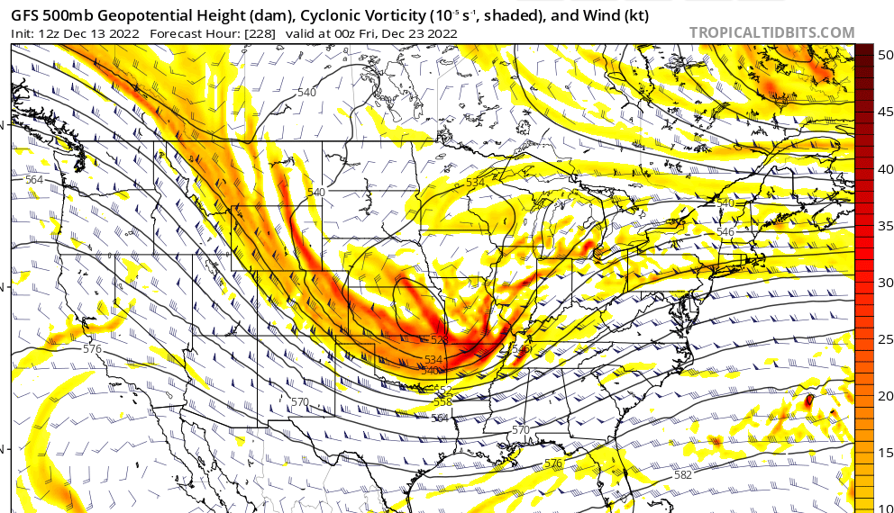
Both GGEM and GFS kind of interesting.
-
Euro prob handled the block the best in the medium range...but it still had its struggles. GFS seemed better at handling the PAC. The block was formidable.....it caused two potential cutters to slide underneath us (12/11 first and then 12/16 later).....12/16 could've been a monster but we were unable to get the whole ULL under us like that Euro run had (and a few other models) on the 12z run the day of the GTG.....so instead we only got a partial lobe extending under us and it allowed too much easterly taint.
-
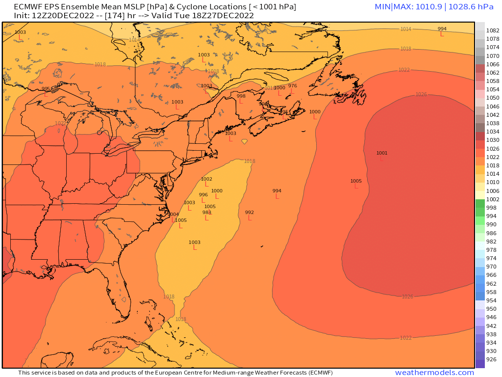
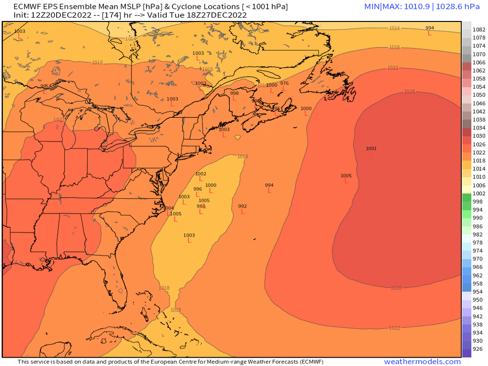
It doesn't....the Dec 25, 2020 comps are not going to pan out. I don't see a prolonged mega-warm sector residence time with the CAD showing up. It will rain and be mild for a time, but it seems like less than 12 hours in the true warm sector....prob closer to 7-8 hours in NNE. Seems like the warm sector hits late morning/midday for NNE and by early evening, Powderfreak is already posting pics of parachutes falling in Stowe as the front passes through.
-
Maybe he was buying the GGEM 12/27 storm.
-
You mean 1998? I think '99 was garbage. '95 was def my best December from a sensible wx standpoint if you like consistent cold and lots of snow events leading into Xmas. That month did leave a little on the table though with the messy phase of the Dec 19-20, 1995 storm....that one was supposed to be a blockbuster but it turned into a mundane warning event. Nothing wrong with that obviously, but there was a little feeling of letdown there. But we had so many snow events it was hard to complain....you had 12/9 over the interior, and then the massively overperofming clipper warning event on 12/14...then the IVT on Dec 16-17 that dropped 2-4" and then of course the bigger storm on Dec 19-20....but then the ULL just sat and spinned up in Maine and we had random snow showers between Dec 21-26 each day. Always seemed to be mood flakes falling with a deep pack. We must've had 18-20" OTG (biggest difference between interior and coast that month was the 12/9 event where coast had mostly rain after snow to start)
-
We had White Tday and White Xmas in 2002....good double whammy there. 1990s were kind of shitty, but 1995 was great. Cold and snowy all December pretty much. 1992 had the leftovers of the Dec 11-12, 1992 storm over the interior....it got a bit glacial because we had a cutter about a week before Xmas, but it wasn't enough to melt it out. 1991 had decent snow cover too...Dec '91 was actually not bad over the interior....and then winter went to total shit after that. 1993 was saved by a band of SN- that dropped an inch overnight 24th into 25th after we lost our snowpack from a grinch storm on 12/23. 1994 was a disaster, 1996 got wiped clean by epic Xmas Eve grinch storm....1997 of course was the infamous 12/23/97 bust that dumped a ton of snow....'98 and '99 were dogshit but '98 did give a white Xmas to far SE areas....the Cape had like 6-10". I think the cutoff was just south of BOS.
-
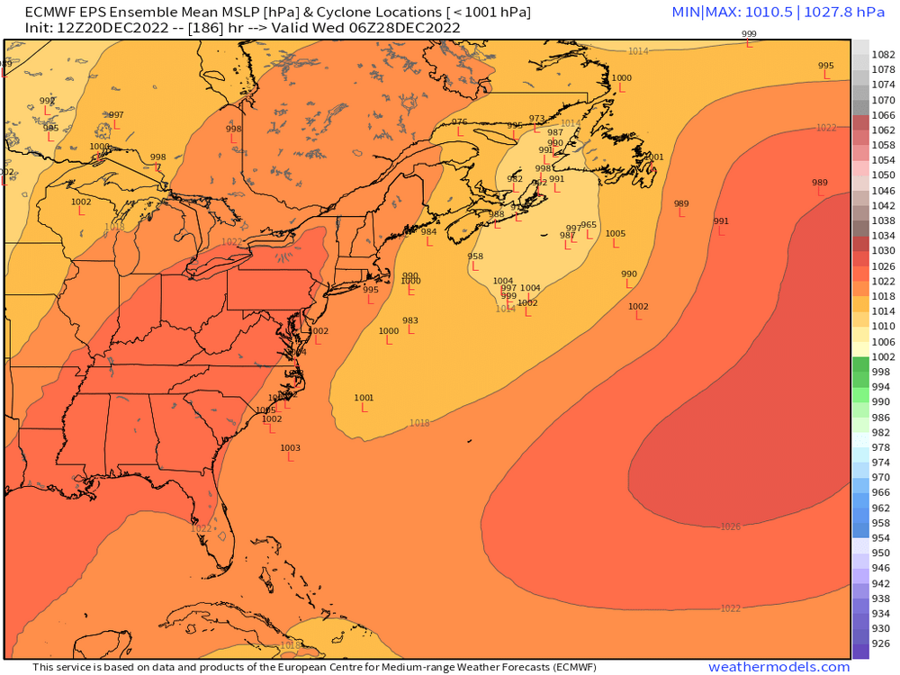
The lead TPV lobe continues to trend eastward (it's doing it again on the 18z NAM as I type).....it will move with perfect precision to ruin any interesting wind component, but not enough for any front end thump.
-
Somehow Leo got his weenie tag grandfathered in or something.
-
Seems like a lot of destructive interference on that look. There is a temp ridge spike out west on 12/26 though, so not impossible to try and sneak a system in there, but it's unlikely.
-
Some of the biggest errors I see in the CC discussions are trying to disentangle underlying longterm anthropogenic climate warming from natural variability over shorter time spans. The northern plains to northern Rockies have a cooling trend in winter since the late 1990s. Does that mean climate change is causing it to be colder there in winter? No of course not. It's natural variability there temporarily overriding the underlying warming trend. Same thing can happen in reverse....somewhere can warm faster than what CC is responsible for, but usually that is natural variability working in the same direction as CC. However, in the latter case, I usually see it all assigned to CC because it's easier to explain that way. The other big errors are often in attribution studies. These are studies that try and show if certain types of events will become more frequent or less frequent in the future. The error most often seen is that the study may have like 4 or 5 emissions scenarios, and the one that makes headlines is the RCP 8.5 scenario which is unrealistic to begin with. But that scenario has the most drastic changes so it makes for a good story. Other times, I've also seen weird stuff where severe arctic outbreaks are blamed on CC like in 2014 in the midwest....when empirical evidence shows that arctic outbreaks are becoming less common.
-
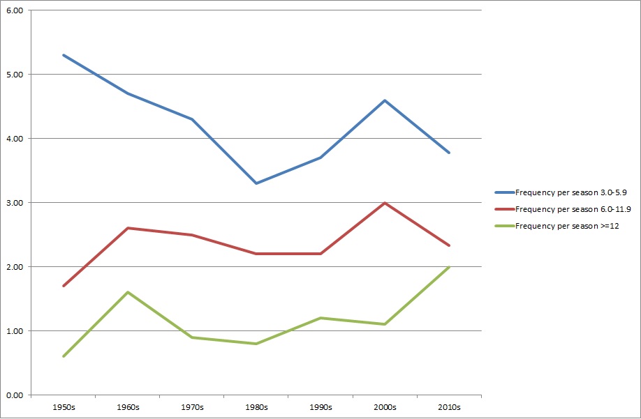
I ran the frequency of snow events by decade for ORH by size....and it's pretty noisy. The conclusion is that 12"+ def increasing, nickels are decreasing (but again very noisy) and moderate events slowly increasing. The 1980s were a shit decade for all types of snow.....
-
Agreed
-
They'll get rain, but the amount of residence time of the warm sector could be minimal up there if the 12z trends keep up....so hopefully the pack doesn't take a big hit.
-
You aren't a credible arbiter of pattern recognition though....