ORH_wxman
-
Posts
93,095 -
Joined
-
Last visited
Content Type
Profiles
Blogs
Forums
American Weather
Media Demo
Store
Gallery
Everything posted by ORH_wxman
-
Mar ‘93 was an epic one too. Esp considering how primitive models were back then.
-
Preliminarily ... a medium impact partial Miller B, Friday
ORH_wxman replied to Typhoon Tip's topic in New England
It’s hard to imagine towns like Gardner/Winchendon/Ashburnham getting less than 6” without a good bump NW on model guidance. Basically all those towns N of rt 2 there. -
Preliminarily ... a medium impact partial Miller B, Friday
ORH_wxman replied to Typhoon Tip's topic in New England
It won’t happen. I probably forecasted for that specific region longer than anyone else alive…lol. One of them will be really wrong. -
Thought that would end up better based on aloft. But either way the threat is clearly there.
-
GFS looks like a mushroom cloud ready to go off….prob gonna be fun in a few more frames.
-
Boxing Day did have it and lost it but it didn’t bring it back until 48 hours out or even less. It was 12z GFS on 12/24 that went nuts and HPC tossed it, lol…then it quickly became apparent at 18z that it had scored a coup as NAM went bonkers and then I think RGEM did (before 18z GFS confirmed the 12z run wasn’t a random model blip)
-
Preliminarily ... a medium impact partial Miller B, Friday
ORH_wxman replied to Typhoon Tip's topic in New England
Either GYX is going to be really wrong in southern Cheshire county or BOX is going to be very wrong in N ORH county. -
Preliminarily ... a medium impact partial Miller B, Friday
ORH_wxman replied to Typhoon Tip's topic in New England
Yeah its fine up there....you're gonna clean up. There was almost this weird dryslot hitting CT and part sof MA briefly early on during that run which changed the progression vs 12z....because it was def shunted more south and colder early on, and then we lost dynamics that run. I mean, the QPF in the CT river valley is like 40% of the 12z run....lol -
Preliminarily ... a medium impact partial Miller B, Friday
ORH_wxman replied to Typhoon Tip's topic in New England
Prob about 1 in 10....it would happen somewhere from late evening to overnight friday night if it happened. -
Preliminarily ... a medium impact partial Miller B, Friday
ORH_wxman replied to Typhoon Tip's topic in New England
It was colder early on....but its starting to be warmer in the more recent frames because the dynamics are definitely weaker this run.....but we'll how it looks in another few frames...it may go to town here overnight friday night. -
Preliminarily ... a medium impact partial Miller B, Friday
ORH_wxman replied to Typhoon Tip's topic in New England
Right....by that token, they weren't worried about that area of 8"+ intruding into Ashburnham on their map? Just weird.... Anyways, 18z NAM coming in colder again -
Preliminarily ... a medium impact partial Miller B, Friday
ORH_wxman replied to Typhoon Tip's topic in New England
LOL....BOX and GYX better coordinate again overnight tonight. The discontinuity in the maps is really obvious....even for a non-Met/non-weenie. -
Preliminarily ... a medium impact partial Miller B, Friday
ORH_wxman replied to Typhoon Tip's topic in New England
BOX and GYX clearly do not agree either....that gradient in N ORH county looks ridiuclous....never seen Rindge get 12"+ while those other towns just south get almost skunked. -
Preliminarily ... a medium impact partial Miller B, Friday
ORH_wxman replied to Typhoon Tip's topic in New England
Lol....how did they get a watch in HFD county out of that map? -
Preliminarily ... a medium impact partial Miller B, Friday
ORH_wxman replied to Typhoon Tip's topic in New England
They already issued their watches this afternoon....unless maybe they add N ORH late? I'm extremely surprised they didn't have them in the first time around though. I mean, it's not a lock in N ORH county, but I'd have to say its def 50%+ for 6" for a lot of that part of the county. -
No....Euro caught on around 132-138 hours out and no other models joined until like 2 or 3 runs later. 12/17/20 was seen over a week out.
-
Preliminarily ... a medium impact partial Miller B, Friday
ORH_wxman replied to Typhoon Tip's topic in New England
I am shocked they don’t have a watch for N ORH county. You only need 50% confidence in 6” for one. -
Preliminarily ... a medium impact partial Miller B, Friday
ORH_wxman replied to Typhoon Tip's topic in New England
I think you and I need another half tick or so to get into something meaningful. I’d be feeling excellent on my old stomping grounds on winter hill….I may make an appearance there on Friday. You’re old stomping grounds are a lock. At least it’s still trackable though. -
We sick… We remember…
-
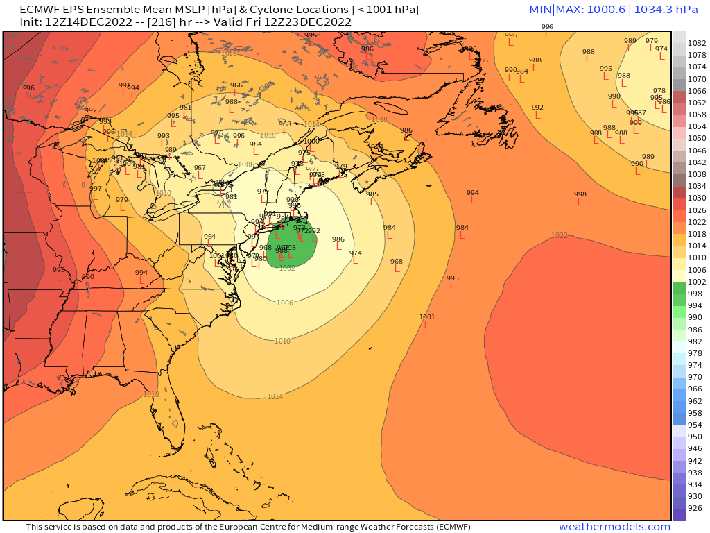
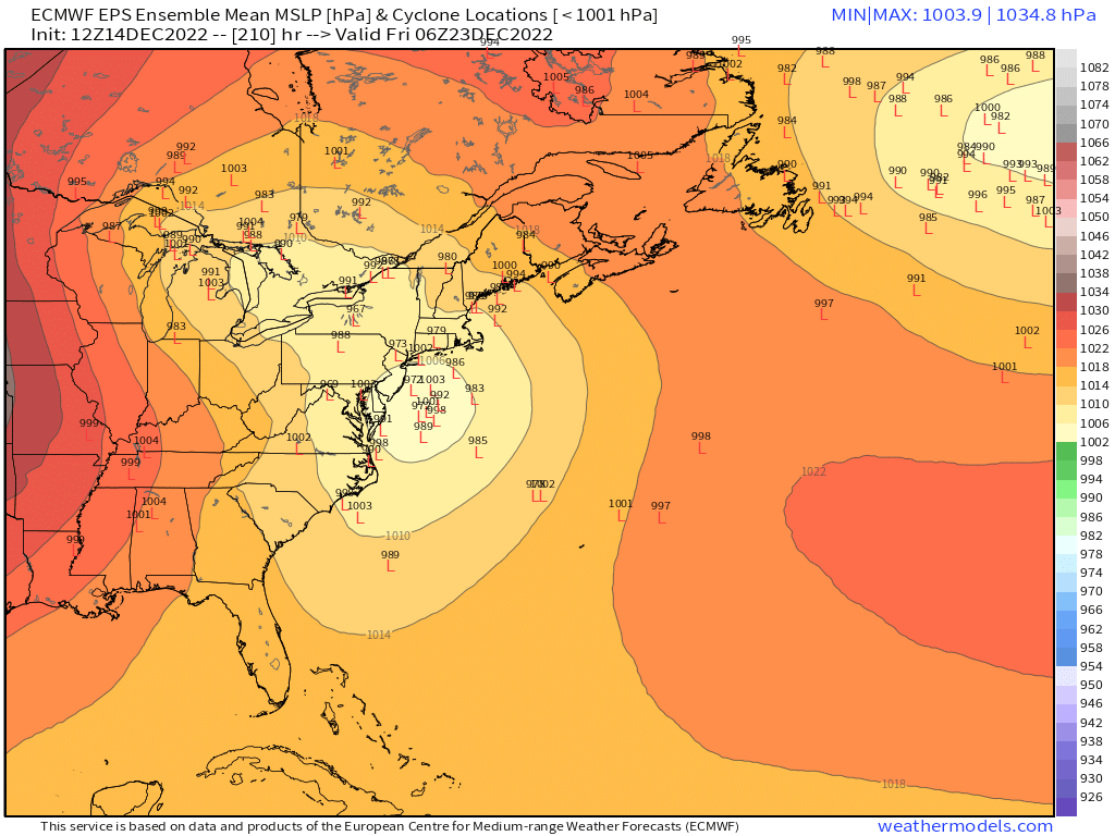
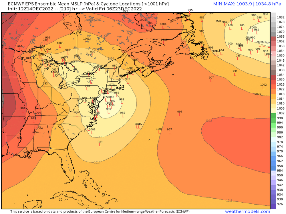
EPS

-
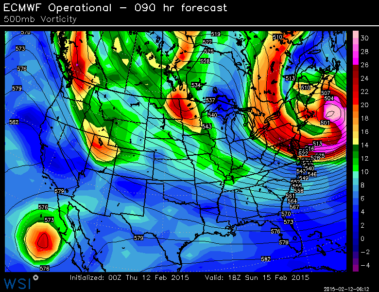
2/15/15 had a similar strength H5 low....though the one on the euro today is much larger in size.
-
Preliminarily ... a medium impact partial Miller B, Friday
ORH_wxman replied to Typhoon Tip's topic in New England
EPS didn't move too much from 06z....maybe a very small tick E.
-
Preliminarily ... a medium impact partial Miller B, Friday
ORH_wxman replied to Typhoon Tip's topic in New England
Just gotta get Dr. No to finally cave....it's teetering, but not quite ready to give up yet. -
That Euro look was much better than last run....that blocking is in a great spot.
-
Preliminarily ... a medium impact partial Miller B, Friday
ORH_wxman replied to Typhoon Tip's topic in New England
New Hartford at 1,000 feet should get crushed in this event