ORH_wxman
-
Posts
93,095 -
Joined
-
Last visited
Content Type
Profiles
Blogs
Forums
American Weather
Media Demo
Store
Gallery
Everything posted by ORH_wxman
-
Preliminarily ... a medium impact partial Miller B, Friday
ORH_wxman replied to Typhoon Tip's topic in New England
06z euro came in a bit better for interior elevations. Prob some decent now for N ORH county that run. -
Preliminarily ... a medium impact partial Miller B, Friday
ORH_wxman replied to Typhoon Tip's topic in New England
Yes. I could easily see your area getting a few inches before a flip. I’m not 100% convinced you don’t get a lot more either. We’ll want to see euro tick SE though pretty soon. -
Preliminarily ... a medium impact partial Miller B, Friday
ORH_wxman replied to Typhoon Tip's topic in New England
06z GFS was a nice little paste bomb for the interior. I def don’t think the interior is out of the game on this one. We’ll want to see the euro come SE a tick. -
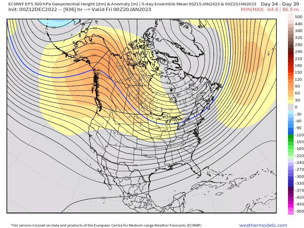
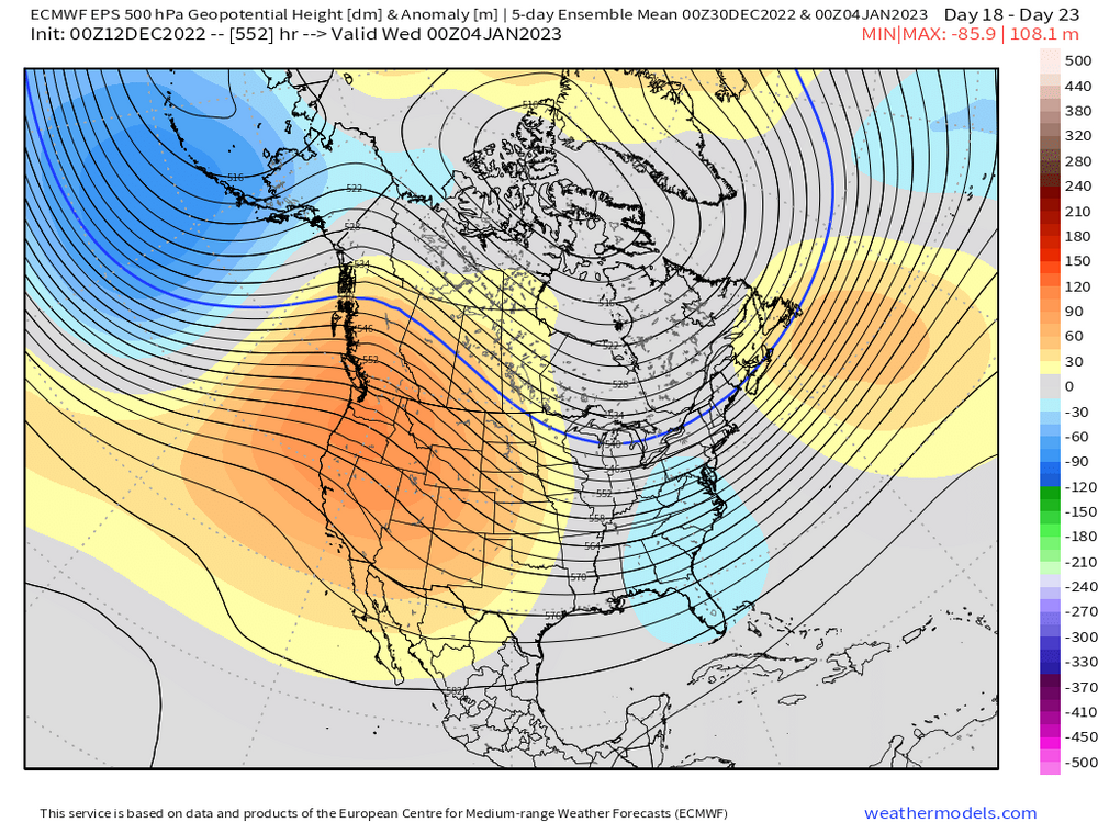
La Niña typically has an Aleutian ridge. Good La Ninas have that Aleutian ridge shooting up into the Bering strait and AK. El Niño typically has an Aleutian low like you see there with corresponding height rises in the PNA region and PAC NW. Bad El Niño’s have the Aleutian low engulfing all of the GOA and giving us a raging PAC firehose….so even if you have a western ridge in the Rockies, there’s no cold air around. But that depiction obviously isn’t like that…it’s more of a “good El Niño” pattern where the Aleutian low stays fairly southwest and pumps the heights in NW Canada so we keep the arctic airmasses coming down.
-
What the fook is that? Lol Hopefully it verifies because we’d prob do really well in northern stream-dominated Nino pattern
-
Tip mentioned to me he was gonna start a new thread on this soon...so I'll give him through 00z suite tonight to write the novel. If he punts on that, then someone should fire one up.
-
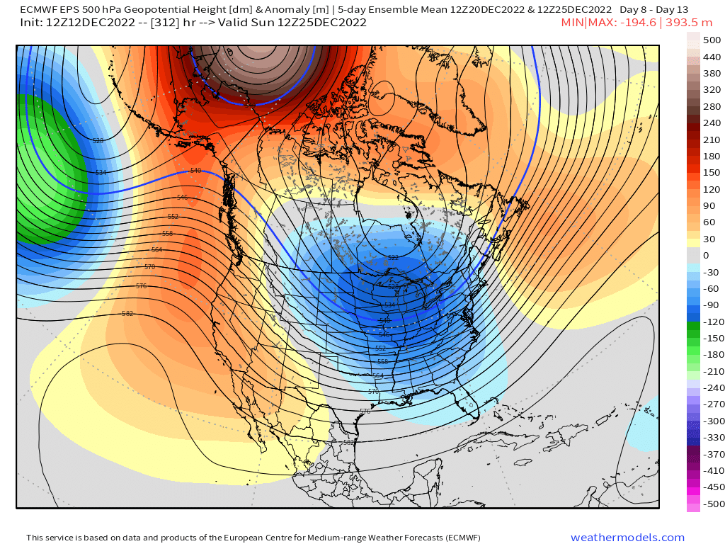
Yeah here's the animation on day 7 through day 10....this isn't in total clown range. You can see how the big Baffin block just forces the trough to move east and not torch us....while heights behind it have to build....simple conservation of mass going on there. It's a nice look....hopefully it produces snow before Xmas, otherwise lots of melts, lol.
-
Models dump the trough initially in the west at D6-7....but there is still a potent Baffin block, so it just slides east with time.
-
That is an insane pattern on all the ensembles....doesn't matter whether its the EPS, GEPS, or GEFS. They all show it. Looks almost El Nino in N PAC.

-
Not at all. You’re a skier too. At least most of those hugger scenarios will hit the ski resorts hard.
-
The storm has officially received a Papal Blessing.....that might be the jolt it needed.
-
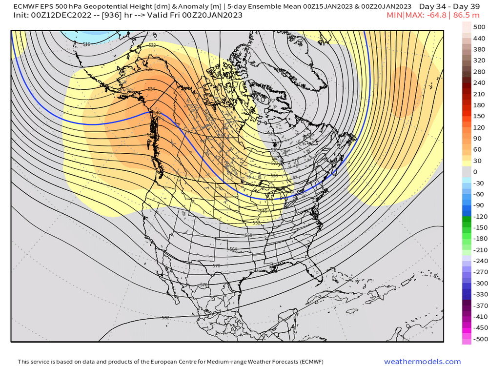
Kind of hard to punt the season when the N PAC starts looking like El Nino with steroidal blocking in the Arctic ocean out in the extended range.
-
And 00z tracked from like LI to PYM....I think if we got that track to come back, it would be enough for interior. When I look at the 102h panel for today, it's colder than 00z 114h panel despite being like 75-100 mi northwest. That's the tick colder I was talking about, but it's obviously hard to compare since we cannot hold the track constant from run to run....but that is evidence in itself that we got a bit colder on that panel in the early stages of the storm despite the track being worse. So I'll be looking for small ticks back SE for interior folks....coastal peeps will need a lot more help though.
-
Repeat after me: Huggers and runners can happen during big -NAO blocks
-
925 track looks slightly worse than 00z.....it is initially colder though, so if we can get this back east a little, I think there is enough antecedent airmass to hit the interior pretty hard.
-
Looks a bit colder at 925, but the track didn't really improve...so the only real difference is maybe a little more snow at the onset. Was hoping to see a jog east but not this run.
-
Yeah I was just looking....def more eastward members and fewer members over interior SNE now. Hopefully that is a sign of a real trend and not just model noise.
-
Ukie did come east and significantly colder in the 925-850 range....but 00z was pretty zonked up so it would have been surprising if it didnt.
-
This is my thinking right now. I don't expect massive wholesale changes, but it's really about 1C of cooling that makes a huge difference and it happens pretty often when you have a ML track southeast of us.....now if the MLs trend back NW, then you can throw that out the window, but assuming a track to the southeast over like the cape or something, I expect MLs and down to the BL 925 range to keep ticking a bit cooler. We even saw this in the Dec 5, 2020 storm with an absolutely putrid airmass....it was so putrid that lower elevations couldn't overcome it, but even they got 1-2" of slop when it looked like all rain 2 days before the event. Higher terrain did get warning snows.
-
Yeah when the ML track does what the GFS did, you're flipping a chunk of that yellow echoes over to parachutes at 33F. I've also been noticing the antecedent airmass at 925mb has been very slowly cooling as we get closer which makes sense because it's a pretty good airmass that gets advected in right before the storm....model guidance often erodes it too quickly...esp over the interior.
-
It's a bit low for ORH (ORH is around 60% in reality) but those national maps are always a little smoothed around localized elevations. Also, it doesn't help that ORH stopped reporting snow depth data in 1994 and there's no real close by coop to pick up the slack. .
-
This storm would be torching Quebec City to 55F and rain if it weren't for the block.
-
A bit over 2" here....just missed that nice band in N RI last night. Otherwise prob wouldve had 4". Still, cant complain.....everything covered pretty nicely.
-
Yerah they did move east some...I'd like to see another move though before determining whether it was just wobbling/noise or a real trend. It's a potent block up near Hudson Bay so at least there's some synoptic support for a move SE.
-
I'm honestly not looking at snow maps really right now. Just looking for trends aloft in the midlevels. We saw a move SE. We need a bit more...esp east of ORH lower down, but there's 4-5 days to do it. If you get midlevels tracking more over the Cape, then it's going to be mostly snow over interior.