

ORH_wxman
-
Posts
93,092 -
Joined
-
Last visited
Content Type
Profiles
Blogs
Forums
American Weather
Media Demo
Store
Gallery
Everything posted by ORH_wxman
-
“Cory’s in NYC! Let’s HECS!” Feb. 22-24 Disco
ORH_wxman replied to TheSnowman's topic in New England
Tblizz grabbing a 20 burger after declaring winter over last week. -
Wednesday Feb 18 Mixed event. NOPE …ain’t happenin’
ORH_wxman replied to HoarfrostHubb's topic in New England
Not on the GFS solution it isn’t. -
Wednesday Feb 18 Mixed event. NOPE …ain’t happenin’
ORH_wxman replied to HoarfrostHubb's topic in New England
GFS skynet is now a little north of the OP on this one. It had previously been decently south of OP but now they are flipped. -
Wednesday Feb 18 Mixed event. NOPE …ain’t happenin’
ORH_wxman replied to HoarfrostHubb's topic in New England
It’s like a 30 mile wide band of moderate snow. Very easy forecast to miss on this one. -
Wednesday Feb 18 Mixed event. NOPE …ain’t happenin’
ORH_wxman replied to HoarfrostHubb's topic in New England
3k was run out of our basements. Narrow high end advisory type stuff right near and just south of pike in eastern areas. -
Wednesday Feb 18 Mixed event. NOPE …ain’t happenin’
ORH_wxman replied to HoarfrostHubb's topic in New England
NAM is pretty cold too. It’s not particularly juicy though. -
BOS 27.6 in that is fake too. They measured too frequently. I remember the scandal at the time but for some reason they just let the total stand
-
Wednesday Feb 18 Mixed event. NOPE …ain’t happenin’
ORH_wxman replied to HoarfrostHubb's topic in New England
Almost nowhere. Maybe a very thin zone of it for about 3-4 hours once the low level cold starts advecting in during the second half of the event…so any glaze should be pretty minimal. Obviously untreated sidewalks and roads can get nasty with just a little, but overall ice will be very minimal imho. -
You’ve only had 2”? I had 4.5” in the norlun on 2/7 and 1.6” last Sunday.
-
Wednesday Feb 18 Mixed event. NOPE …ain’t happenin’
ORH_wxman replied to HoarfrostHubb's topic in New England
Best lift looks below DGZ on most guidance too so I don’t love it. But some of these runs have very intense rates for 2-3 hours. So if someone gets a surprise 4-6”, it will be because they prob ended up in a narrow area of very strong lift/rates. -
Wednesday Feb 18 Mixed event. NOPE …ain’t happenin’
ORH_wxman replied to HoarfrostHubb's topic in New England
I’m thinking 2-4” here…maybe 1-3”. Well see how quickly things cool. -
Yeah and it’s tedious enough that we could get almost nothing from this next 7 days too. Though I don’t think we’re done after Monday by any stretch. There’s risk for some warmth or rain but 18z GFS and some of these other random runs show you how it can break very very snowy too. Lots of cold lurking up north in the extended.
-
Def better aloft there. AI having such a strong signal for Monday makes me feel like we’ll trend that way but I’d like to figure out the first two systems first. They are all over the place. Friday especially has been all over the place. Wednesday is a hard forecast because of how narrow the heavier precip is…Friday night is literally like 0” to 12” for possible realistic totals.
-
18z gfs gone wild in the extended too
-
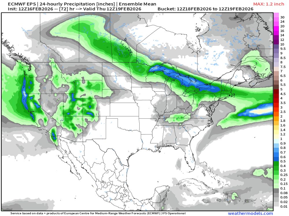
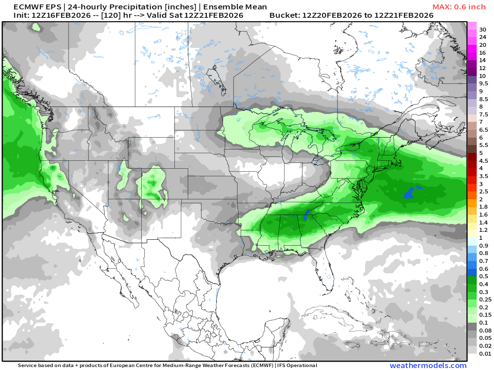
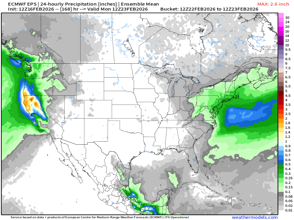
EPS for each threat… Wednesday Friday night Sunday night/Monday
-
That is def not ‘78 that tip posted. I’ve memorized that one too.
-
Yeah the spine ORH hills from Paxton/Rutland/Princeton/Westminster is where you want to focus those larger totals. It drops off to the west near barre once you are on the west side of the slopes. Lot of easterly flow in that storm so the spine and eastern slopes did well.
-
That’s 3/31/97. I’ll never forget that h5 look.
-
Yeah pretty much all of N ORH county from Worcester northward had 20”+ (and prob most of northern half of Middlesex county). My guess is the airport prob had 24-25” but we can’t change it. We were on ne.weather back then and there was a dearth of Worcester county reports (esp northern half). We had a guy measure in Paxton (28”) and Rutland (27”) so we felt good about a general 24-28” in the towns immediately north west of ORH. There were 30 burgers up near NH border like Winchendon I think reported 30. Can’t remember what Ashburnham coop had but I remember we all thought it was super low (prob because they just stuck a yard stick in the ground at the end). Southern half of county was more like 16-20”….a lot of storms played out like that during 2000-01. Northern half of the county got destroyed.
-
Icon is a warm outlier for Monday but as long as we’re talking model solutions, it’s def rain for almost all of SNE at the height of the storm.
-
If you like rain. Even for your area.
-
Wednesday Feb 18 Mixed event. NOPE …ain’t happenin’
ORH_wxman replied to HoarfrostHubb's topic in New England
GFS is low end warning for parts of W MA and CT. -
I had 26.5” just on the north side of ORH in the Mar 2001 event. Airport I think under measured in that one. Their final report came out hours before the steady snow ended and it was never updated. They just kept it at 22.0”. Those 1997-2001 years were ASOS disaster years at ORH and BDL.
-
Wednesday Feb 18 Mixed event. NOPE …ain’t happenin’
ORH_wxman replied to HoarfrostHubb's topic in New England
NAMs went south a decent tick…RGEM and ICON very small ticks south. Basically noise on those two. -
Wednesday Feb 18 Mixed event. NOPE …ain’t happenin’
ORH_wxman replied to HoarfrostHubb's topic in New England
Not much. This isn’t a huge inverted airmass oozing down…we might see a little more of that on the weekend threats but this one is mostly rain vs snow. Could be a very narrow area of IP and marginal ZR but we’re prob talking like 10-20 miles wide.


