ORH_wxman
-
Posts
93,099 -
Joined
-
Last visited
Content Type
Profiles
Blogs
Forums
American Weather
Media Demo
Store
Gallery
Everything posted by ORH_wxman
-
“Cory’s in NYC! Let’s HECS!” Feb. 22-24 Disco
ORH_wxman replied to TheSnowman's topic in New England
The old SREFS had a bunch of ETA members in there so the synoptics were decent (even the old RSM members weren't bad synoptically either)....but now it's all convective models. -
“Cory’s in NYC! Let’s HECS!” Feb. 22-24 Disco
ORH_wxman replied to TheSnowman's topic in New England
NAM is coming in at a higher angle of attack....that's good for us I think...it won't get cutoff down east of delmarva and miss us like previous runs. -
“Cory’s in NYC! Let’s HECS!” Feb. 22-24 Disco
ORH_wxman replied to TheSnowman's topic in New England
The IVT look got worse tomorrow, but it helps us Monday....we move that whole system east a bit quicker tomorrow so it is one of the factors that helps move Monday further north. -
“Cory’s in NYC! Let’s HECS!” Feb. 22-24 Disco
ORH_wxman replied to TheSnowman's topic in New England
I want to see it keep coming west now because I’m def feeling a messenger shuffle with this one. -
“Cory’s in NYC! Let’s HECS!” Feb. 22-24 Disco
ORH_wxman replied to TheSnowman's topic in New England
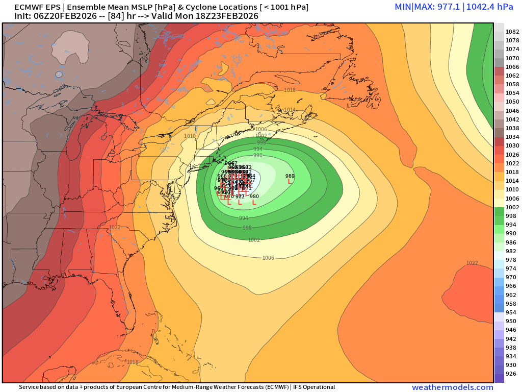
06z eps
-
“Cory’s in NYC! Let’s HECS!” Feb. 22-24 Disco
ORH_wxman replied to TheSnowman's topic in New England
Reggie looked pretty decent. I’d expect GGEM will be NW. But if the GFS starts drifting SE, then we’re sticking with the Red Sox analogies. -
“Cory’s in NYC! Let’s HECS!” Feb. 22-24 Disco
ORH_wxman replied to TheSnowman's topic in New England
The key is the GFS. If that keeps doubling down and not drifting SE then it gets more interesting. -
“Cory’s in NYC! Let’s HECS!” Feb. 22-24 Disco
ORH_wxman replied to TheSnowman's topic in New England
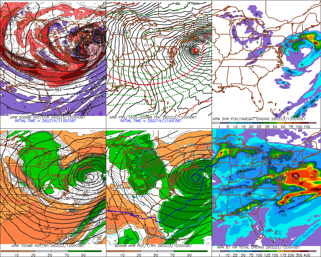
The 21z ARW wipes SE MA and the Cape off the map.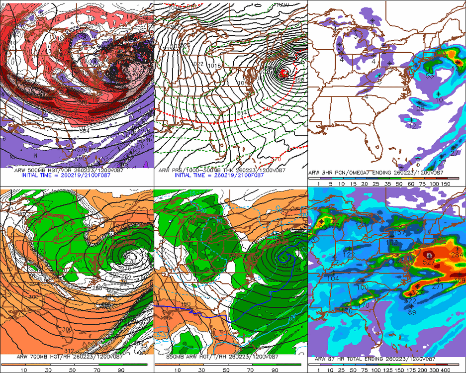
-
“Cory’s in NYC! Let’s HECS!” Feb. 22-24 Disco
ORH_wxman replied to TheSnowman's topic in New England
“Breaking: Red Sox show interest in signing Kyle Tucker. An anonymous source close to the FO says they are in discussion amongst themselves on making a semi-competitive offer…tune in for updates tonight.” -
“Cory’s in NYC! Let’s HECS!” Feb. 22-24 Disco
ORH_wxman replied to TheSnowman's topic in New England
Feb 1st redux on model guidance....GFS takes the place of the Euro in that one while all the others keep doing their various foreplay dances but never get around to closing the deal. I love the John Henry Red Sox analogy...."we were interested and made a competitive offer"....that's what this likely will be. -
“Cory’s in NYC! Let’s HECS!” Feb. 22-24 Disco
ORH_wxman replied to TheSnowman's topic in New England
Yep. March has some of our best storms. I think after the big SWFE in late January and the pristine deep snow pack that followed for weeks with a few refreshers gave everyone a Sugarloaf Maine to Mt Mansfield vibe and as soon as that started to break like it did over the past week-plus, a bunch of weenies start ending winter. It was a little disappointing to not add into that impressive pack but at the same time, I’m not rushing in mud season either and won’t pretend 2010 or 2012 are around the corner. That isn’t how it works here and there is a reason for many of us that March averages more snow than December…not just vibes. -
“Cory’s in NYC! Let’s HECS!” Feb. 22-24 Disco
ORH_wxman replied to TheSnowman's topic in New England
It’s def still possible for a huge event down there. I think we’re cooked inland. Never say never but it’s getting late. Cape doesn’t need nearly as big of a move. -
“Cory’s in NYC! Let’s HECS!” Feb. 22-24 Disco
ORH_wxman replied to TheSnowman's topic in New England
There’s been a really bizarre vibe in this forum the last few days to end winter after the Monday threat. It’s like we’re supposed to pretend we live in Virginia or the Carolinas….i guess the 2022-2024 period was so bad that some thought they actually did live there. The extended range pattern doesn’t look like an early spring for us either. -
“Cory’s in NYC! Let’s HECS!” Feb. 22-24 Disco
ORH_wxman replied to TheSnowman's topic in New England
Already did that earlier. -
“Cory’s in NYC! Let’s HECS!” Feb. 22-24 Disco
ORH_wxman replied to TheSnowman's topic in New England
Very similar to late January for that Feb 1st system when the Euro was on an island for a few runs. All other guidance was contorting itself with a plethora of different looks that all produced no snow. This time it’s the GFS but same idea. The misses look tantalizing but they miss for a reason. -
Yeah we can at least agree with him this time that he’s not getting much from this one. Maybe an inch or two on Saturday though depending on mesoscale stuff.
-
“Cory’s in NYC! Let’s HECS!” Feb. 22-24 Disco
ORH_wxman replied to TheSnowman's topic in New England
The problem is we need more than decent changes at h5 on models like the Ukie that still result in a whiff. We needed that 24-48 hours ago. We’re getting close enough now that having the GFS on an island is an obvious red flag. Euro is gonna have to come north west solidly for me to entertain a large hit. -
“Cory’s in NYC! Let’s HECS!” Feb. 22-24 Disco
ORH_wxman replied to TheSnowman's topic in New England
Yeah GGEM is basically a whiff. Some light snows for eastern areas but nothing of significance. -
Wish Reggie was correct with warning snows here but I’m on the side of Ray’s map…I think 2-4” with lots of crud in there is the more likely scenario. Could even be less too if something like 12k NAM is correct but seems to be an outlier on the QPF being so light.
-
As the heights crash and the ML dryslot approaches late tomorrow evening, some of the guidance shows very intense precip…Reggie was hitting this but even the 3k NAM has it now too (not really the the 12k)….there could be a heavy burst of snow for 2-3 hours or so if the column is cool enough.
-
“Cory’s in NYC! Let’s HECS!” Feb. 22-24 Disco
ORH_wxman replied to TheSnowman's topic in New England
NAM is an unmitigated disaster in SE Canada for getting any type of storm even close to us. Have to hope it’s just the clown range NAM being the clown range NAM. -
Gotta watch Saturday. Look at how deep the DGZ gets underneath that rapidly crashing H5 wave. Wouldn’t take much for someone to stack some fluffies if a little LL convergence sets up overhead. North shore might be in a good spot again…don’t expect norlun totals again but some enhancement is def possible.
-
NAM is decently south of 06z. The WAA thump though looks weak and disorganized. The best snows for us down here might be as the heights are collapsing after the WAA “thump” very late Friday evening and then during the day on Saturday when hangback moisture is prevalent in a very deep DGZ.
-
“Cory’s in NYC! Let’s HECS!” Feb. 22-24 Disco
ORH_wxman replied to TheSnowman's topic in New England
So we’re all holding out on the OP euro. -
Wednesday Feb 18 Mixed event. NOPE …ain’t happenin’
ORH_wxman replied to HoarfrostHubb's topic in New England
What idiot started this thread?