ORH_wxman
-
Posts
93,092 -
Joined
-
Last visited
Content Type
Profiles
Blogs
Forums
American Weather
Media Demo
Store
Gallery
Everything posted by ORH_wxman
-
Yeah it looks that way to me too. Maybe extreme SW CT in like the Greenwich/Stamford area has some legit taint during the heaviest stuff but I think northeast of there is good with snow during the heavy stuff.
-
It’s possible it could still turn into an inch or two pike south. Obviously I’d root for it but I think it’s mostly far southern areas that have a legit shot. We’ll see though. Still a couple of days to try and nudge it back north a bit.
-
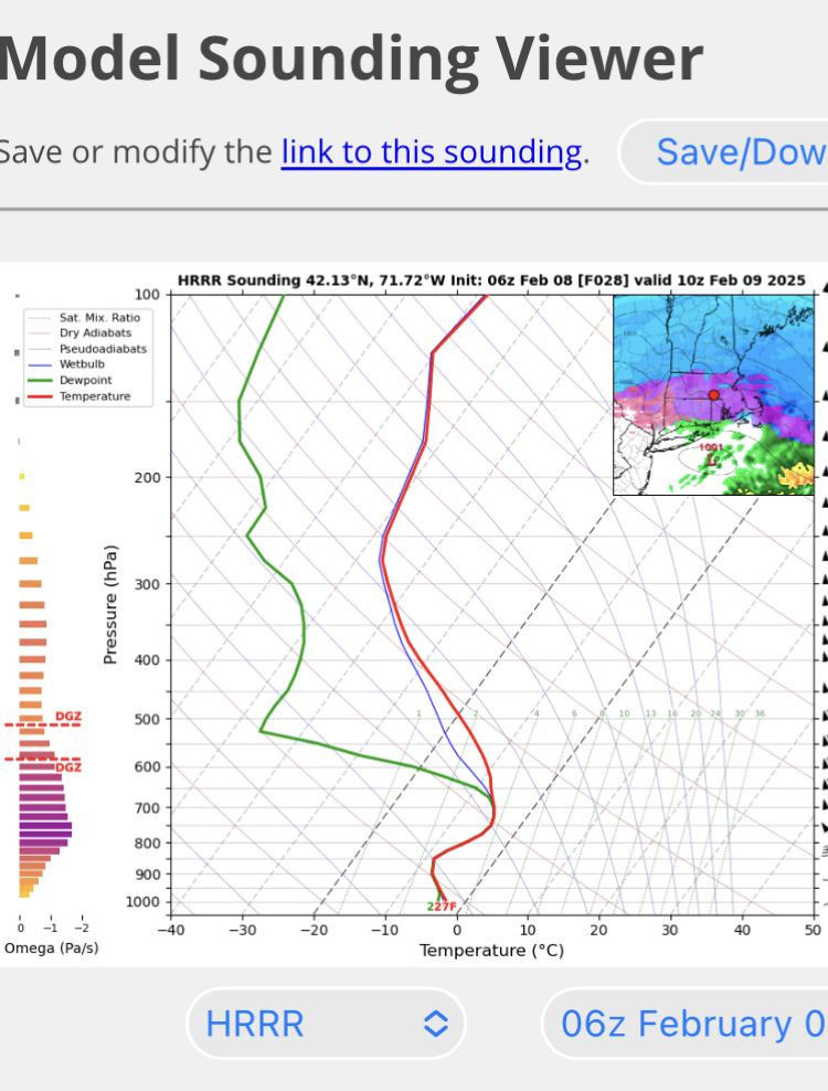
Yeah honestly I think I can count on one hand how many times I’ve actually seen ZR/FZDZ here when the entire column is below freezing. It usually has to be warmer than like -3C or -4C and often the saturated zone is very narrow and low to the ground…like it dries out above 900-850 or so. Anytime I’m seeing ptype algorithms try to screw around with saturated columns up to 750 and -5C and -6C temps…tossed. Always ends up as just cruddy snow growth.
-
Yeah that would make a lot more sense. I try to forget that storm up here.
-
There will be plenty of meat from Thursday’s event whether you load the pack with dense SWFE snow or it’s a lot of sleet/ZR…either way, you’ll add some beef to the pack I think anyway. Meatiest snow in this event is prob south of pike.
-
2/1/21? 1/4/18? 3/7-8/18?
-
It does it all the time I’ve noticed when the DGZ dries out. Problem is they never seem to take into account salt nuclei which is obviously plentiful where we live on east and southeast flow in the lower midlevels.
-
Fake. Look at soundings.

-
Tuesday night looks mostly dead. Maybe south coast gets a little bit. That would have to trend north really quickly.
-
That run was from your basement…
-
I also think the HRRR’s ptype map is fake. Much of the sleet area is just the DGZ drying out but the column is still like -2 or -3 in the warm layer. It would just likely be worse snow growth.
-
Purple? Looks blue to me. Did you do purple punch puff the magic dragon tonight?
-
Sure but the colder it trends, more QPF would fall as snow. I think the 2/16 threat might synoptically be more favored for a larger impact icing threat. The high looks a bit further west in that one. But I do like where the 2/13 high is as the storm comes in. It’s like running the system into a brick wall and those can often produce huge front end thumps.
-
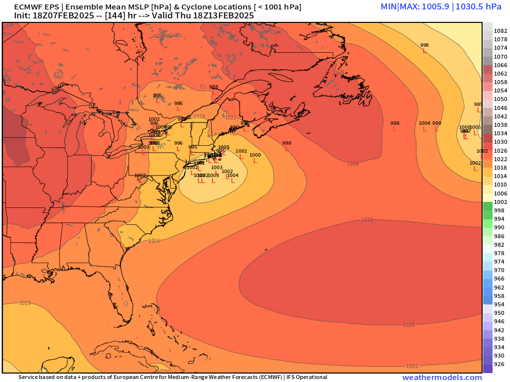
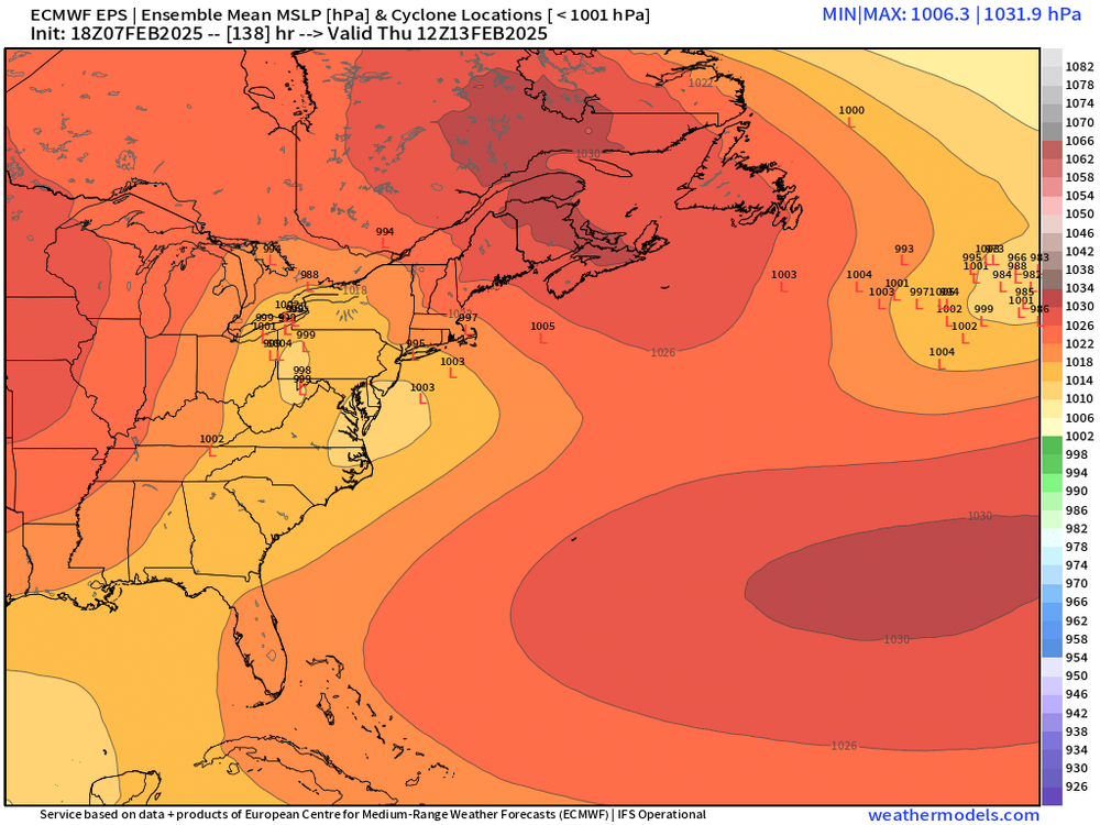
Heh…posted the new EPS at the same time you posted new GEFS…both pretty similar. Definitely an upside threat there (obviously we know the risks too)
-
18z EPS is definitely trended colder with faster redevelopment for Thursday
-
18z Euro looked a little thumpier for Thursday. I think that one still has some solid upside…obviously risks too as we know. But there’s some 12/16/07 possibilities there (maybe even something better if we can redevelop it quicker?)….good airmass ahead of it if the synoptics can do ok.
-
He still posts like it’s 2001 where it took a super computer to post images.
-
Yeah it usually takes a real big dog to close Logan. I’ve seen them stay open during some pretty decent storms. That said, there will be plenty of delays and some cancellations sprinkled in.
-
I think even a lot of the Cape might break 6"....guess it depends how pasty it gets in the 2nd half of the storm.
-
2/16 back to being a big snow hit on GFS....that one is prob gonna be all over the map for a bit.
-
Decent chance it’s at least delayed. The airport likely isn’t closing down though from this one.
-
I think if you started being pessimistic only in the last 3 years then your credibility would be almost totally intact. But let’s be real, you started it long before, lol. But correct on the rainers…much wider area for rainers to “verify” versus snowers or whiffs. I think it’s good to point out the risks but we should point out the upside too…when it’s there of course. This pattern does have considerable upside but there are plenty of risks. We’re playing right along the gradient and that is always inherently a high risk/high reward spot to be. The last 2.5 winters have had a lot of bad longwave patterns with also some bad breaks on top of it when we did get a favorable look. So yeah, it’s easy to assume we’re going to get the bad breaks again. We did get a lot of good breaks during our snow blitz years…these things do have a way of evening out over time. Hooefully we catch a couple good breaks this next week or two.
-
I like how the 850 closes off and deepens as it crosses the south coast. That how you get good weenie bands to the north of it. You’re also probably going to prolong some hang-back precip too early Sunday with the extra inflow.
-
Last storm was also quite a bit different in that even though the NAM was “right”, we’re talking like 1-1.5” vs 3” of snow. It wasn’t that big of a difference. In this one, it’s a little more of a gap. If the NAM comes up a couple tenths on QPF then the differences will be fairly small. So we’ll see what happens the next run or two.
-
The OP NAMs are really the only guidance not giving 6”+ for our zone of SNE (basically pike region)…think we good.