

ORH_wxman
-
Posts
93,099 -
Joined
-
Last visited
Content Type
Profiles
Blogs
Forums
American Weather
Media Demo
Store
Gallery
Everything posted by ORH_wxman
-
Yeah it could end up as a nice event but we still need it south a bit more. PV still being a bit obnoxious but at least we’ve trended it better overnight. Need another trend at 12z though or I think it’s gonna be tough. Can’t reverse the overnight trends.
-
That’s a pretty decent icer outside of 495 on 06z euro. ORH never gets above freezing.
-
06z euro is def a bit south of 00z
-
1-2” might be pushing it. Might just be a C-1, then sleet and a little ZR before the slot over the interior.
-
EPS did have more members south. Mean snowfall jumped too…around 6” for pike region. Fingers crossed we can press that a touch more south.
-
We're gonna have more chances to screw it up too beyond this weekend. The pattern might be even more favorable after that....we'll see how it progresses, but decent agreement on western ridge building.
-
To be fair, nothing this week has really been a big coastal....it's always been overrunning and trying to be on the correct side of the gradient....this coming weekend sort of looked like it could redevelop into a coastal at one point, but it was like 80% overrunning precip even on those scenarios. It's really the perfect storm of missing all the forcing at all the "correct" times to minimize our snow....there's big overrunning to our south tomorrow which is going to whiff us....then by the time the boundary moves north, we have an ill-timed shortwave riding well west of us to prevent good overrunning snows on Wednesday night and Thursday....so we're left with weak sauce precip....then of course on Saturday night and Sunday, we've alreayd mentioned the PV rotating into a surgically perfect location to knife the banana high in half to allow the storm to ride up right between them and screw us that way. Sometimes, you just get cold cards....maybe we can still salvage the weekend.
-
Weekend deal is not an icestorm unless you have that high anchored. Icon at 12z had it but no other guidance save maybe Ukie.
-
GFS is gonna be south of 12z with weekend. PV pressed a bit more this run.
-
The next 7 days aren't very snowy on the Euro...it was out in clown range that it got snowy again.
-
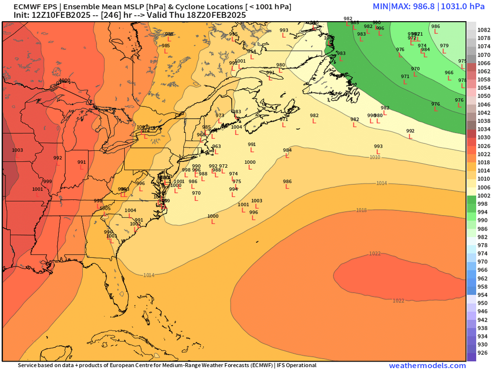
20th does have a pretty good signal on EPS…been there for a couple days Even the weekend still has about 25% of the members as pretty huge hits. I’m not optimistic on weekend but not totally resigned to a rainstorm yet. The 2/20 threat synoptically looks excellent though as the 2/16 system becomes a huge 50/50 low as it phases with the PV fully after passing us. So you combine it with a western ridge and there’s obviously potential. Not worth going crazy though until we get much closer.
-
The problem is we have no anchored high pressure on the weekend. Synoptically it looks horrific unless we press that PV back eastward/southward.
-
No reason to stray from 1-2” with some IP/ZR in this one…maybe 1-3” covers any lucky spots. Weak dynamics and low QPF.
-
Rains to Maine on Euro. Too bad another perfectly-timed PV modulation prevents another big event. That 2/20 event looks awesome though, lol.
-
Maybe Ukie can be right for once. Big snow (to some ice at the end SOP)
-
Yes. Not biting yet though. It’s the icon and most other guidance has been showing warmer solutions the last day or so.
-
GFS is def juicier but don’t buy it until there’s more support.
-
Yes it is....mesolow was good on that for ice over interior after the initial snow thump.
-
Prob not until precip is all done over interior...looks like a fast slot.
-
Yep, weak sauce.
-
Help with what? accumulations? Limiting factor is QPF, not cold. Maybe it helps marginally during light rates.
-
2/6 last Thursday might be the best match....a little colder maybe but similar paltry QPF and paltry dynamics....unless we get a bit more shift eastward.
-
Yes I think this prob the best way to snow this coming weekend....the PV trends in Canada have been very bad the last 24-36 hours....I suppose they could reverse but I'm growing more skeptical.
-
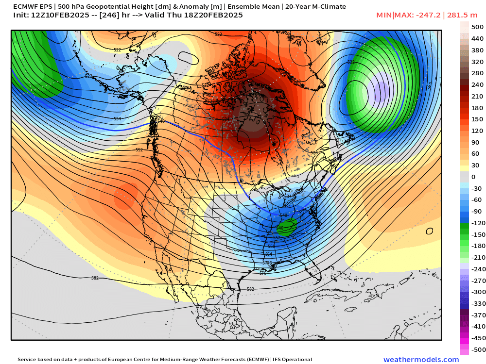
I’ve been so focused on the next few events I didn’t really look at any longer term stuff but I noticed big signal around 2/20 and then beyond that the EPS building a huge PNA ridge

-
Yeah if Thursday does decent and then we pound on the weekend, we’re well on our way to making the winter respectable…pretty much guaranteed rat if we go weak sauce thursday and then weekend is an ugly rainer. I looked at all those good runs even on the euro a few days ago and the PV was much more firmly anchored in SE Canada. We need to see that trend again. Not only does it keep this south but it also produces the confluence for a solid high. Notice how on these solutions where the PV is further west, we sneak a perfectly timed low pressure up the St Lawrence valley so there’s basically zero high…it splits it in half so you have one retreating to the Flemish cap and the other stuck out in western/central Canada. PV being west of James Bay is never good when you have a western trough moving east.


