ORH_wxman
-
Posts
93,099 -
Joined
-
Last visited
Content Type
Profiles
Blogs
Forums
American Weather
Media Demo
Store
Gallery
Everything posted by ORH_wxman
-
If you get a fairly robust partial phase this could def just slice through BUF and flood all of New England. I’m skeptical right now because the block is actually strengthening and pressing southward during this…but we’ll see. If we have a rainer on guidance still by Tuesday 12z, we’re likely cooked.
-
Much worse than 12z GEFS. Prob a lot more members pulling that partial PV phase to the west.
-
Yeah it’s going to flip flop a lot I think over the next 24-36 hours until we get more inside of D5-6. Note what the PV was doing that run…it wasn’t anchored in SE Canada and had some lobes rotating pretty far west helping the western shortwave partially phase and amplify rapidly.
-
That map is terrible too. No way the 495 belt is less than 50” per year. Not until you get down towards Mansfield/Norton. Not sure what the sub-50 is in SE NH too. My guess is Brattleboro is somewhere in the 60s for seasonal average in the valley there knowing what the averages are a bit further south in the CT river valley
-
Rgem and Icon look pretty thumpy at 18z for Thursday. But clown range for those models. Icon especially since it gets a secondary going a bit quicker. You want to see secondary reflection sooner to help with inflow and better dynamics. Otherwise it’s a 3-4 hour burst of WAA precip and dryslot.
-
I’m not sure any model supports 6” of snow for anywhere in New England for Thursday. Maybe the Canadian was marginal for that since it was a little juicier and further east than other guidance.
-
Not very coherent on the clustering ……looks more like Buck shot…but yeah, we’re still a week out.

-
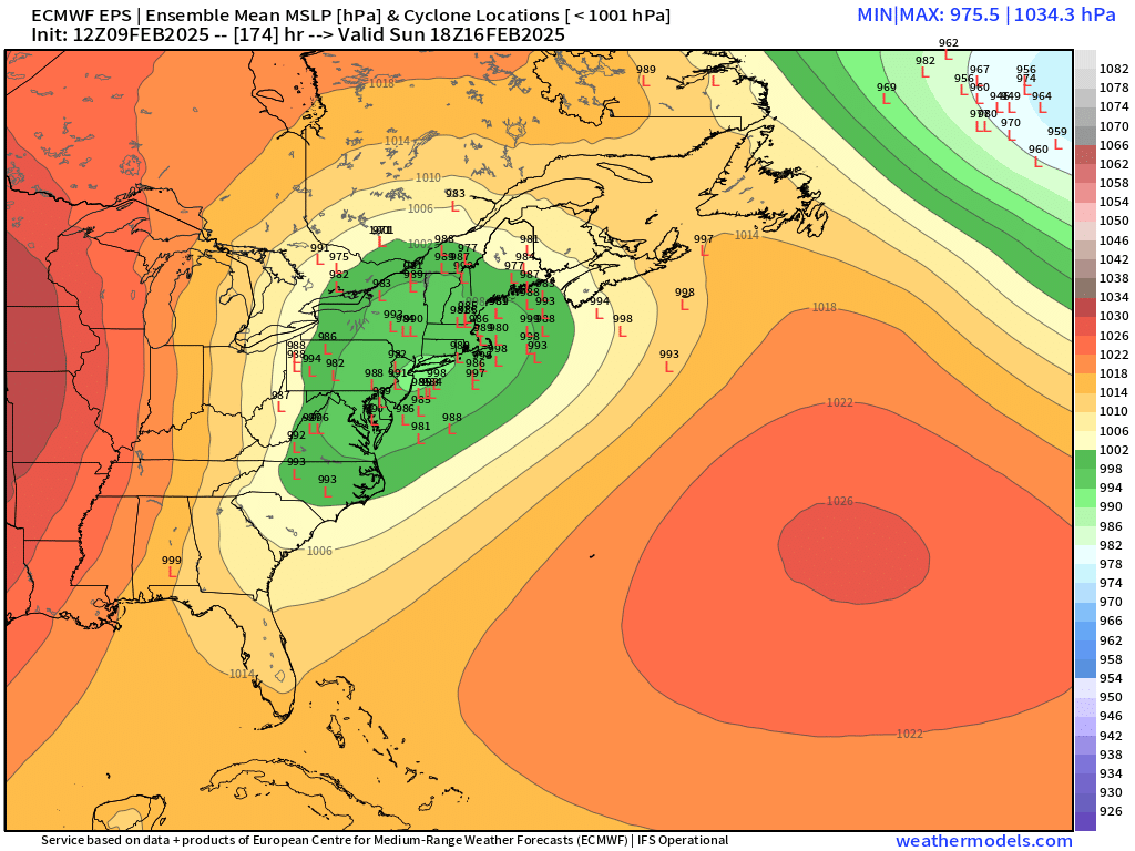
That’s kind of late in the system. Back that up 2 frames. Huge spread on EPS. But the mean is like 7” for the pike region despite plenty of members looking like the OP run. But there’s also plenty of members that have huge hits well into double digits.
-
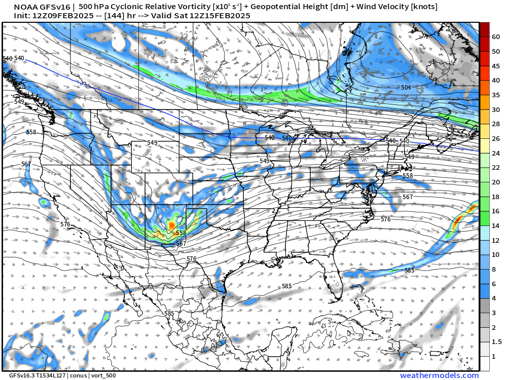
Here’s GFS. Look how much further southeast it is with PV in eastern Canada…fully east of Hudson’s bay
-
The key for next weekend aloft is for the PV to be pressed and stay ahead of the main shortwave coming out of the west.
-
Rain up to the chickens on euro but the primary did squash some that run…the other main difference is we had no high north of maine this time to spring a secondary reflection. It’s just one low that basically track over our heads. Still a higher end threat though. Wouldn’t take much to push that into a major snowstorm.
-
No eastward bump on euro. Primary actually goes west of CLE. Still quite cold but very paltry on precip.
-
Can’t see past 144 yet but Ukie looks pretty pressed for next weekend too.
-
This looks colder than last Thursday. Still not sold on much precip unless we can subtly continue nudging this east. GGEM and GFS did so at 12z…we’ll see if euro bites. But absent that shift east, it’s prob like a 1-3/2-4 type deal on the front end followed by some IP/ZR and then dryslot. Maybe up north gets a little more where they don’t flip to pellets.
-
That is Kevin’s dream storm. It’s like 42-48 hours straight of snow on GGEM over SNE next weekend. Goes from Saturday afternoon to Monday afternoon.
-
I think impact-wise it makes sense but it’s really hard to verify so the snowfall threshold is just easier to stick with.
-
WCB was pretty disappointing in this event. Looked like we had enough inflow to pound for 5-6 hours but it was really just about a 3 hour deal. I think at the end of the day, the synoptics really can be a guideline…it’s hard to hammer solid warning criteria for us when you have a vort going from Toronto through the chicken coops…we’re south of all of that…so you prob just get that initial surge like we saw down in NYC and LI and then it kind of runs out of deeper level support and weakens a bit when there’s a lack of PVA and the extra divergence aloft that comes with it. Hopefully we can grab some dynamics in these next couple systems. Weekend looks better but subtle shifts east today make Thursday slightly more interesting.
-
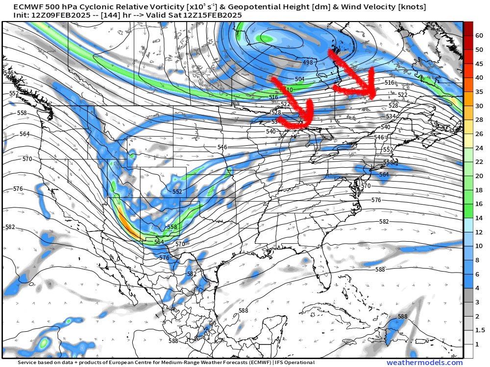
The GFS shows you how to do a big thump for next weekend. Get that midlevel warm front really defined and slow it down just south of us and you pound town for 6-8 hours. You’ll note the vort isn’t riding up through Lake Ontario and instead comes through the Ohio valley and swings toward northern midatlantic.
-
GFS really pressing confluence for next weekend this run. Looks like it’s gonna be a pretty cold system this run
-
Been a subtle shift east so far at 12z. That’s a trend we want to see if we want better dynamics. Still kind of meh on most guidance thus far but a little better than what we saw yesterday and last night Primary is a little southeast of that CLE to Toronto line now…more like BUF to ART. Nudge that a little more and maybe we can go thumpy thumpy on the front end.
-
5.2” looks like it will do it with that final band of pure fake champagne. The first 4” or so was prob 10 to 1 at most while the final inch or so was like jspin fluff.
-
Unless this moves east in the final few days, take the under on 4-8….it’s like 0.3-0.5 QPF and then dryslot. Primary a couple days ago was going through PIT and dying around ROC/SYR, but now it’s going up through CLE and dying near Toronto. We don’t get that healthier and more dynamic WCB when it’s that far west.
-
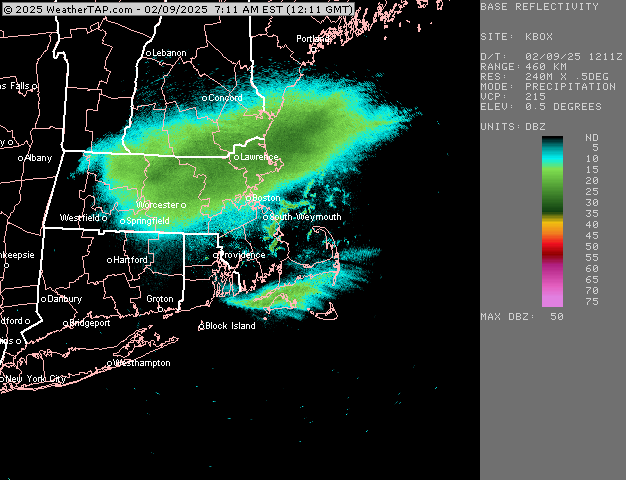
This band is a nice bonus right now. Total fluff…prob 18 to 1 minimum maybe more. Can fake my way to another inch on top of the denser stuff. Measured just shy of 5” about 15 min ago…looks nice out there
-
06z euro has about 3” of snow and then a shot of IP/ZR before slotting. QPF looks pretty meh. We need to get more vorticity eastward on this one to make it a little higher impact.
-
Actually ripping very good now in this. Hopefully pick up a quick inch or so here. Excellent snow growth