baltosquid
-
Posts
1,236 -
Joined
-
Last visited
Content Type
Profiles
Blogs
Forums
American Weather
Media Demo
Store
Gallery
Everything posted by baltosquid
-

Feb 22nd/23rd "There's no way..." Storm Thread
baltosquid replied to Maestrobjwa's topic in Mid Atlantic
Truly cannot draw up that track any better. -
Feb 22nd/23rd "There's no way..." Storm Thread
baltosquid replied to Maestrobjwa's topic in Mid Atlantic
The atmosphere should let the GFS win for once. It really is trying its best. -
Feb 22nd/23rd "There's no way..." Storm Thread
baltosquid replied to Maestrobjwa's topic in Mid Atlantic
Can you even do the G and F word for the GFS at this point? It’s the Guys Folks System at this point lol. But if it ain’t caving, I guess the digital blue will be pretty. -
Feb 22nd/23rd "There's no way..." Storm Thread
baltosquid replied to Maestrobjwa's topic in Mid Atlantic
Heights don’t look higher to me but the wave is deeper I think. -
Feb 22nd/23rd "There's no way..." Storm Thread
baltosquid replied to Maestrobjwa's topic in Mid Atlantic
It was extremely stubborn with the snowcrete storm. Every run we’d say surely, now it will cave… took a while and instead was a slow bleed. -
Feb 22nd/23rd "There's no way..." Storm Thread
baltosquid replied to Maestrobjwa's topic in Mid Atlantic
lol RRFS A was better. Doesn’t mean much. -
Feb 22nd/23rd "There's no way..." Storm Thread
baltosquid replied to Maestrobjwa's topic in Mid Atlantic
Yeah it has a better h5 pass but still all IVT over a narrow strip. A bit NW in low placement. -
Feb 22nd/23rd "There's no way..." Storm Thread
baltosquid replied to Maestrobjwa's topic in Mid Atlantic
Just can’t get the thing to tilt in time. Verbatim a little stronger at h5 but it’s just not wrapping up. Need a cleaner look. Which we probably won’t get. -
Feb 22nd/23rd "There's no way..." Storm Thread
baltosquid replied to Maestrobjwa's topic in Mid Atlantic
Don’t think the RGEM is gonna do it seeing it at hr60 as it is a bit flatter. Stronger trailing wave but I don’t think it will have room. Would love to be wrong! -
Feb 22nd/23rd "There's no way..." Storm Thread
baltosquid replied to Maestrobjwa's topic in Mid Atlantic
NAM also wants to make that trailing wave to the NW stronger but it’s too messy. Bad interactions. -
Feb 22nd/23rd "There's no way..." Storm Thread
baltosquid replied to Maestrobjwa's topic in Mid Atlantic
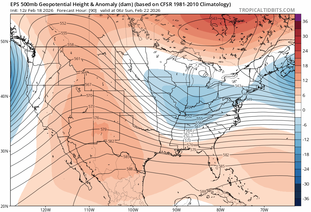
On the EPS. Pretty big jump to this dual wave look. There was a hint of it earlier if you look at the height lines closely but as you can see, it really took off at 06z. If there’s still more to go on focusing things to the west then we could definitely score. But remain in a look like this and most likely the two waves just get in each other’s way as the op demonstrated.
-
Feb 22nd/23rd "There's no way..." Storm Thread
baltosquid replied to Maestrobjwa's topic in Mid Atlantic
Yeah potentially. Heights are higher behind at their peak (compared to 00z) but also not as steep in general since the pacific trough jumped north a bit. Go back to the prior PNA look and maybe it results in a steeper ridge behind the wave? -
Feb 22nd/23rd "There's no way..." Storm Thread
baltosquid replied to Maestrobjwa's topic in Mid Atlantic
Like this is objectively a pretty good trend on h5, at least I think so. But 06z specifically just struggles to tilt because of unhelpful interactions between the two waves. Keeps it positive even though the placement and strength is better. In the good ending, this is a transitional run and we keep shifting W with the main energy and that blunting of the heights lessens. In the bad ending, well, most models show that already.
-
Feb 22nd/23rd "There's no way..." Storm Thread
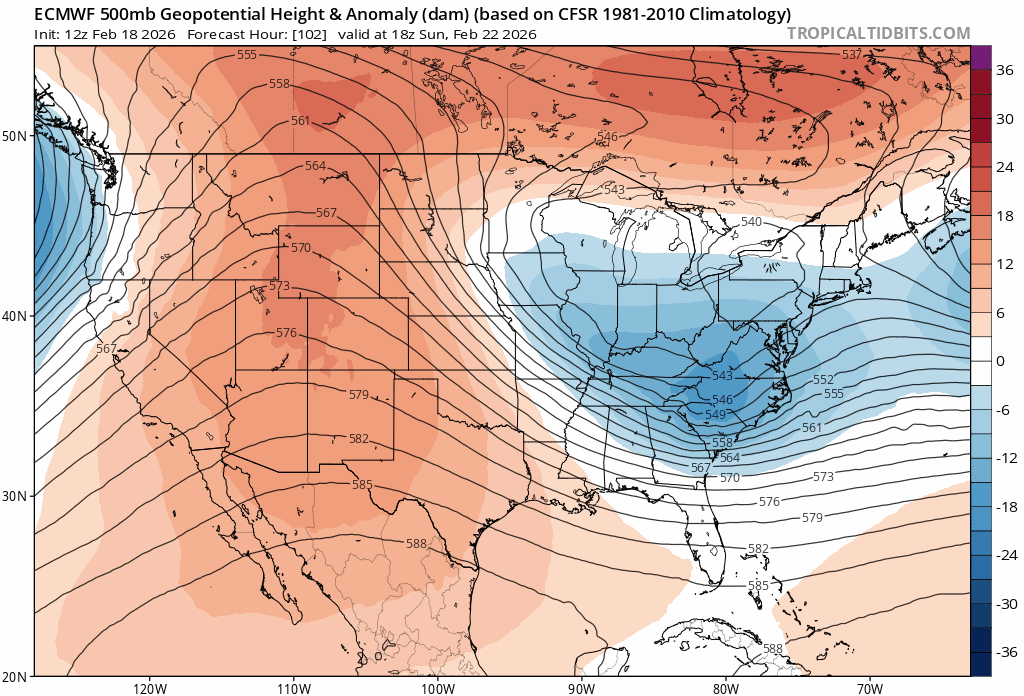
baltosquid replied to Maestrobjwa's topic in Mid Atlantic
Ugh, really can’t help but think we’re so close looking more at the euro… higher heights behind to support a stronger trailing wave, which is centered further W and stronger, and the heights ahead did not get worse and really in the large scale maybe got a bit better, but for our neighborhood the leading wave blunts them. -
Feb 22nd/23rd "There's no way..." Storm Thread
baltosquid replied to Maestrobjwa's topic in Mid Atlantic
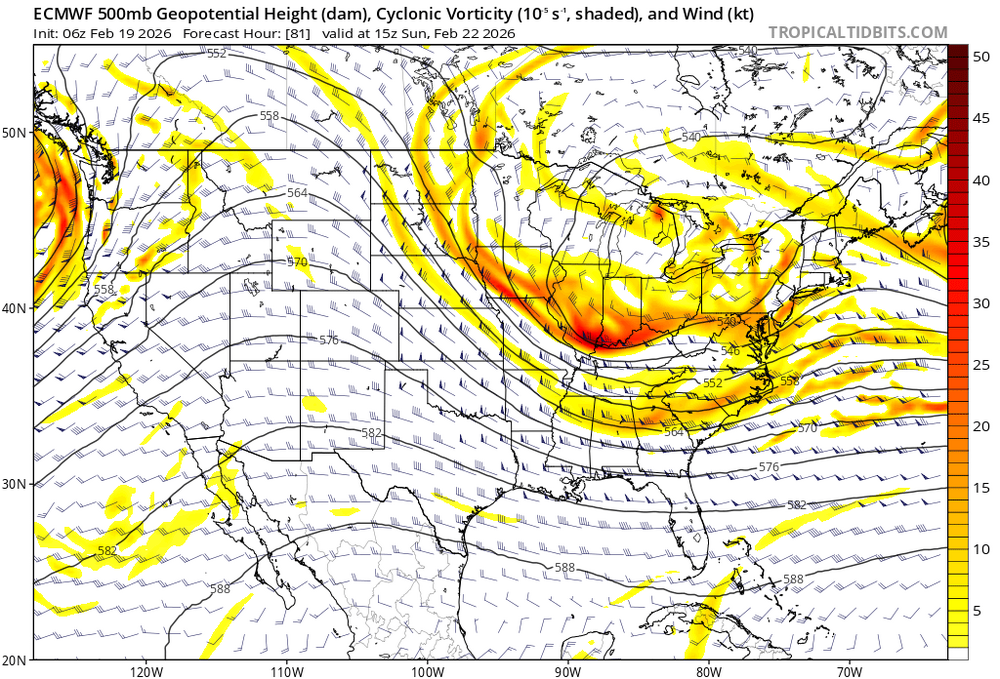
Warning, amateur analysis ahead… Looking at the h5, the euro isn’t that far… but the tendency for the NS to not play nice makes it a difficult task to fix the presentation. See hr66: There are two waves - the tighter vort in the Dakotas and the broader energy centered in Illinois. Roll this forward to just about game time: Follow the 540 line. The leading wave is ceding to the trailing vort but it is still too much of an independent force. It blunts the heights immediately in front of the wave trying to tilt. Imagine if that wave just wrapped in a little faster. Straighten out the 540 line so it doesn’t have that southward kink. Now things have more room to amplify. Earlier negative tilt. Better chance of capture and a boom - probably not far inland, but close enough to maximize the event in a realistic way. This in a vacuum is not a huge thing to hope for… a little weaker with the front wave, or a little slower so the trailer can wrap it up further west, or maybe the confluence lightens up further upstream and allows things to still strengthen even with some messy spacing. But the short lead time with lacking ensemble support and the apparent seasonal trend for messy, crowded NS interactions makes it tougher to believe in it getting done. all done… feel free to point out my mistakes, they are probably numerous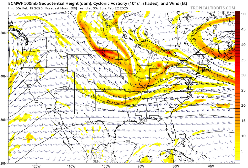
-
Feb 22nd/23rd "There's no way..." Storm Thread
baltosquid replied to Maestrobjwa's topic in Mid Atlantic
We always end up here, hoping the GFS somehow scores a coup. -
Feb 22nd/23rd "There's no way..." Storm Thread
baltosquid replied to Maestrobjwa's topic in Mid Atlantic
You know what they say. The biggest factor for snow is your... longitude. -
Feb 22nd/23rd "There's no way..." Storm Thread
baltosquid replied to Maestrobjwa's topic in Mid Atlantic
GEFS h5 is a step in the right direction. Heights higher ahead, trough deeper and closer to negative at 84. -
Feb 22nd/23rd "There's no way..." Storm Thread
baltosquid replied to Maestrobjwa's topic in Mid Atlantic
Yeah UKMET is southeast. Whereas the GFS and CMC were able to get the trough in a situation where it could still deliver (former more so), UKMET is what happens if both the heights ahead and the trough don't cooperate. Total whiff. -
Feb 22nd/23rd "There's no way..." Storm Thread
baltosquid replied to Maestrobjwa's topic in Mid Atlantic
Don't think UKMET is gonna do it with a broader trough and lower heights but we'll see. H5 most closely resembles the Canadian but flatter imo. Maybe it pushes for a negative tilt and rescues something. -
Feb 22nd/23rd "There's no way..." Storm Thread
baltosquid replied to Maestrobjwa's topic in Mid Atlantic
Worse than 12z but still keeps a very similar idea. I really don't think it's worth panicking over (not saying anyone is). Decent 00z so far. -
Feb 22nd/23rd "There's no way..." Storm Thread
baltosquid replied to Maestrobjwa's topic in Mid Atlantic
My thinking is, that confluence from the exiting low is gonna give us fits pretty much right until the last 24 hours. So as the GFS shows, maybe it's better to just hope the trough just deepens more! That made this run work regardless of the confluence. -
Feb 22nd/23rd "There's no way..." Storm Thread
baltosquid replied to Maestrobjwa's topic in Mid Atlantic
Feels like the euro is just too fast. A little slower with the energy moving down and across the conus and I think it looks a lot more like the GFS and CMC. -
I mean it may well be that this is one of those particularly annoying setups where an AI model is just not gonna catch the details a deterministic one can. That’s the hope at least!
-
Euro AI more suppressed unfortunately