baltosquid
-
Posts
1,236 -
Joined
-
Last visited
Content Type
Profiles
Blogs
Forums
American Weather
Media Demo
Store
Gallery
Everything posted by baltosquid
-

Feb 22nd/23rd "There's no way..." Storm Thread
baltosquid replied to Maestrobjwa's topic in Mid Atlantic
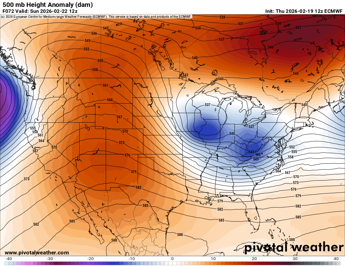
I mean the exact placement of the IVT is harder to parse… I think getting a better h5 pass and something a bit more amped are some clear trends to hope for. The GFS isn’t going to be right. We are not going to get crushed by a sub 980 over the Chesapeake. But a trend towards something less pathetic is good. -
Feb 22nd/23rd "There's no way..." Storm Thread
baltosquid replied to Maestrobjwa's topic in Mid Atlantic
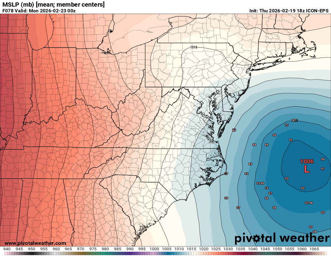
ICON-EPS has one lonely captured member… this is an improvement from 12z, when it had none.
-
Feb 22nd/23rd "There's no way..." Storm Thread
baltosquid replied to Maestrobjwa's topic in Mid Atlantic
H5 looked a bit better for both the RGEM and ICON but still letting the surface get away from us before we could capture. Rather this than getting worse but a long ways to go to get anywhere near the GFS of even 06z, let alone 12z. -
Feb 22nd/23rd "There's no way..." Storm Thread
baltosquid replied to Maestrobjwa's topic in Mid Atlantic
NAM doesn’t appear as flat as the euro at least. Trough appears a bit sharper as well. -
Feb 22nd/23rd "There's no way..." Storm Thread
baltosquid replied to Maestrobjwa's topic in Mid Atlantic
NAM seems to only disagree more with the GFS over the Alberta low placement this run. It’s a bit north from 12z and a bit less interactive I think. But idk. This feature is too complex for me honestly. -
Feb 22nd/23rd "There's no way..." Storm Thread
baltosquid replied to Maestrobjwa's topic in Mid Atlantic
NAM is running. If we can’t even get a NAMing out of this threat then that just makes the GFS even crazier. -
Feb 22nd/23rd "There's no way..." Storm Thread
baltosquid replied to Maestrobjwa's topic in Mid Atlantic
The JMA from today has been out on TT and is indeed more GFS like than some of the others. I think that was just a mispost. It’s still not as crazy as the GFS. -
Feb 22nd/23rd "There's no way..." Storm Thread
baltosquid replied to Maestrobjwa's topic in Mid Atlantic
Anyone with weatherbell want to share what the Korean model thinks? Might as well cast a wide net. oh, and that French one! Surely one of them will have something… -
Feb 22nd/23rd "There's no way..." Storm Thread
baltosquid replied to Maestrobjwa's topic in Mid Atlantic
My suggestion for that entry: “You are mentally ill. Put down tropical tidbits.” -
Feb 22nd/23rd "There's no way..." Storm Thread
baltosquid replied to Maestrobjwa's topic in Mid Atlantic
Need @psuhoffman to add “The GFS and JMA show snow” to his chart -
Feb 22nd/23rd "There's no way..." Storm Thread
baltosquid replied to Maestrobjwa's topic in Mid Atlantic
FWIW the euro (all of them, Op, AI, ens, ensAI) did trend to a stronger wave… it’s just such a shitty arrangement of pieces. Idk what it would take to get them to play nice from ~36 on like the GFS has. But that’s the problem we’ve come to know quite well. Crowded NS stepping on its own feet. -
Feb 22nd/23rd "There's no way..." Storm Thread
baltosquid replied to Maestrobjwa's topic in Mid Atlantic
This is not going to tilt, obviously. GFS consolidates those. Euro does not.
-
Feb 22nd/23rd "There's no way..." Storm Thread
baltosquid replied to Maestrobjwa's topic in Mid Atlantic
Worse than 06z Euro AI I mean -
Feb 22nd/23rd "There's no way..." Storm Thread
baltosquid replied to Maestrobjwa's topic in Mid Atlantic
Yes, a bit. Looks like the wave interaction was worse and it was more positively tilted. -
Feb 22nd/23rd "There's no way..." Storm Thread
baltosquid replied to Maestrobjwa's topic in Mid Atlantic
Prepare for strong emotions in a direction yet to be determined -
Feb 22nd/23rd "There's no way..." Storm Thread
baltosquid replied to Maestrobjwa's topic in Mid Atlantic
GEFS showing a mean of 6-10 inches 10:1 less than 100 hours out would turn into quite the fail lol. -
Feb 22nd/23rd "There's no way..." Storm Thread
baltosquid replied to Maestrobjwa's topic in Mid Atlantic
GEFS looks good. Just following its weenie leader. -
Feb 22nd/23rd "There's no way..." Storm Thread
baltosquid replied to Maestrobjwa's topic in Mid Atlantic
Yeah UKMET wasn’t as flat as 00z but it is still garbage and nothing like the GFS unfortunately. Ptype problems -
Feb 22nd/23rd "There's no way..." Storm Thread
baltosquid replied to Maestrobjwa's topic in Mid Atlantic
Actually maybe the UKMET is not so bad. It’s no GFS though. Don’t think temps are gonna be friendly either. -
Feb 22nd/23rd "There's no way..." Storm Thread
baltosquid replied to Maestrobjwa's topic in Mid Atlantic
As expected, the UKMET looks less amped -
Feb 22nd/23rd "There's no way..." Storm Thread
baltosquid replied to Maestrobjwa's topic in Mid Atlantic
If they’re running it out of a MARC train, that would explain some things -
Feb 22nd/23rd "There's no way..." Storm Thread
baltosquid replied to Maestrobjwa's topic in Mid Atlantic
Snow too heavy, ground gives way. The DC snow hole. -
Feb 22nd/23rd "There's no way..." Storm Thread
baltosquid replied to Maestrobjwa's topic in Mid Atlantic
I mean I shared some pics earlier of the euro’s look and to summarize, it really isn’t unfair to say this is a delicate setup that can still boom with some minor adjustments even to the most hostile model depictions. Now the GFS goes ahead and decides to make as perfect of a set of adjustments as possible to improve its already ideal look… don’t really buy that. But something more sane that gives us a great storm? I don’t think it would be crazy. -
Feb 22nd/23rd "There's no way..." Storm Thread
baltosquid replied to Maestrobjwa's topic in Mid Atlantic
I would be up all night trying to keep up with shoveling… otherwise I’d be trapped. -
Feb 22nd/23rd "There's no way..." Storm Thread
baltosquid replied to Maestrobjwa's topic in Mid Atlantic
Don’t get excited about the Canadian as it will likely just be the RGEM with minor changes. First chance to get some agreement is the UKMET