

baltosquid
-
Posts
1,236 -
Joined
-
Last visited
Content Type
Profiles
Blogs
Forums
American Weather
Media Demo
Store
Gallery
Everything posted by baltosquid
-
Low heights ahead might be the bigger killer at this point, hard to say what’s the worse thing though. But the HRRR improves both here I think.
-
Trailing wave is very intriguing to me. Dives way in compared to 06z. That would be a pretty aggressive change, unfortunately hard to trust the HRRR with that given it is coming in from its boundaries. But would love it if somehow that wasn’t a meso hallucination.
-
12z HRRR is out to the normal range (18hrs) so far and looks more amped. Obviously utility decreases exponentially beyond the normal range. And even at 18 it is not so great. But these particular changes can be spotted before that too. Wonder what it will look like in la la land.
-
At h5, the reversion to 12z tilt and also lower heights out front seem to be obvious hindrances. Then there's however the trailing vort is messing with things. It ends up between 06z and 12z in terms of results. Well, hope it's not getting true revenge and this is just a windshield wiper deal. Edit: actually was just looking at the precip shield and low placement but the inverted trough is crap this run. I feel like that's weird as it has loved that feature. Really hope we haven't passed the high water mark.
-
Yes, basically if that keeps coming in fast it can start interacting more usefully with the trough, whereas if it is far away it won't hinder it from tilting, and landing in the middle area will prevent an easy tilt.
-
AI is basically back at 12z for totals, to put it in perspective.
-
Euro AI might also be mucking up the tilt with the trailing vort. Came closer this time, so maybe it was in a spot to be destructive. Maybe it can come closer again and pass out of the destructive zone into a more constructive one. We'll see... hopefully a blip.
-
Looks like the AI makes the trough too broad. I'm behind on pivotal so have to wait and see if that is the fly in the ointment.
-
CIPS is beginning to like this more. Top 12z, bottom 00z.
-
-
Ukie is still the warmest surface but it is way better than 18z. Give it another nudge and I think it would stop raining so much.
-
Ukie looks more amped. Let's see if it finally beats the temps it has been doomsaying about.
-
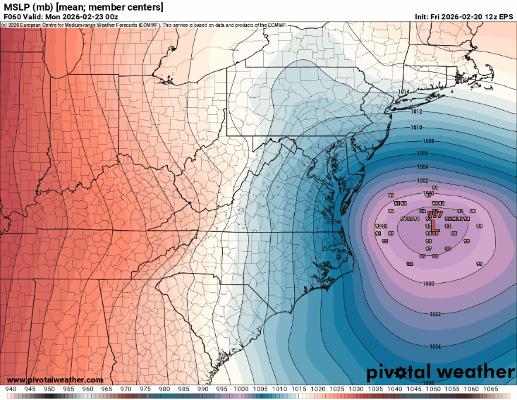
At this point the ensembles are so tightly clustered it hardly matters. But worth noting, 00z GEFS is kind of contradictory. QPF department, more/west, low placement is a tiny tick east. But the GEFS has kind of stair stepped at times toggling back so I wouldn't be worried about the end of the fun yet. Could very well just be noise. And I'll mention again the trailing wave... keep that inching closer and it might help more.
-
"Best frontogen always is NW of modeling" or something like that
-
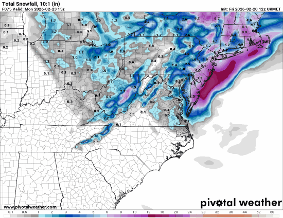
GFS also has Monday afternoon light snow for much of MD and eastern VA, for a daytime snowglobe
-
That trailing vort is getting closer and closer. There's still potential there. Crazy.
-
Not sure where bncho is but I'll say at 24 the heights are higher both behind and in front. Edit: bncho arrives!
-
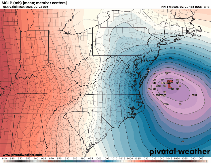
ICON ensembles. Get. Over. Here!
-
NAM 3km is much closer to the 12km depiction this time. Glad that divergence was apparently just a blip at 18z.
-
Just like last run, feels like surface maybe even lagged the h5 improvement a bit! Feels like a low even closer to the coast than depicted could be justifiable based on that run.
-
The stormtracker out of town index, or SOOTI, was crucial to these trends. We will build a monument to your sacrifice. But in all seriousness, thanks for all you do and wish you could be here if this does go HECS. Hope you're building massive karma to get mauled yourself soon enough.
-
Yup, while the upper atmosphere is plenty cold for snow we have a shit surface temp to deal with. Heavy precipitation will cool us down and then we'd basically be pinned to around 32 degrees. We'll lose some accumulations to white rain and ratios will suffer early even after accumulations begin until that happens, and then the ratios will be "fine", nothing insane. So the instantaneous ceiling is probably 10:1 but the event ceiling depending on where you are could be 5-8:1
-
While it's the SREF, trends are trends are trends... love that the most striking cluster is on the boom end of things.
-
I think those western ones are pretty satisfying!
-
Watching the Euro across all its offerings juice the ridges behind and in front of the trough sure is something. Concerning the EPS in particular, I really want to see at least a couple aggressively tucked members... a tick W would be good don't get me wrong, but seeing the upside cases show up would make me more confident the trend will continue.


