

baltosquid
-
Posts
1,236 -
Joined
-
Last visited
Content Type
Profiles
Blogs
Forums
American Weather
Media Demo
Store
Gallery
Everything posted by baltosquid
-

Outta gas and Outta Time: Early March Winter Storm finale
baltosquid replied to Ji's topic in Mid Atlantic
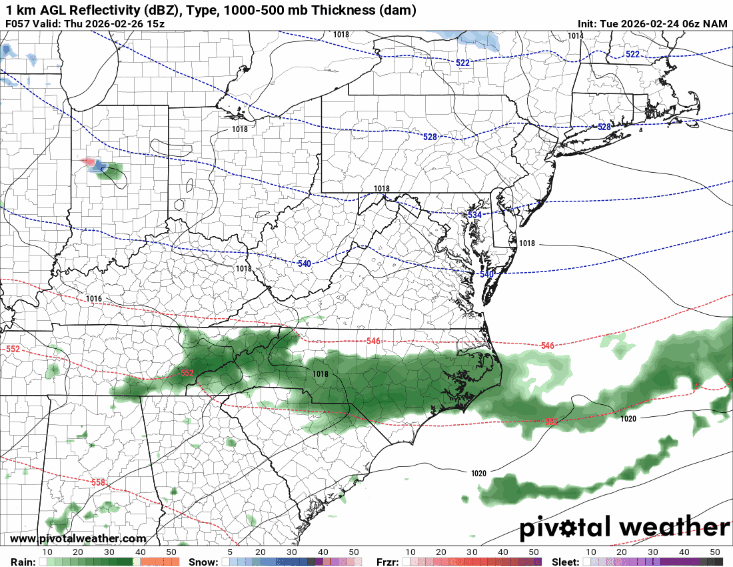
Includes Thursday stuff, 24hr still a good warning level event for many though -
Since it is next, figured I would look at the UKMET trends leading in. FWIW it is trending more amped and a touch slower. It brought the precip a good jog north at 06z responding to this change. Another nudge like that and we probably get more precip at 12z. But I am not expecting snow even with an amped nudge; UKMET seems to run pretty warm.

-
AIGFS did come north but temps are bad.
-
Even with the pretty much ceiling outcome the GFS has, surface temps are above freezing the whole time. Probably another accumulation failure in the metros and an inch or two “jackpot” somewhere. Granted, maybe if the NAM 3k controlled the temps with the GFS look, maybe it would spit out something more favorable, idk.
-
Who knows, maybe it’s on a heater and it’s amp o’clock in the atmosphere
-
Nada from the RGEM and ICON. Hires window mesos technically had some digital blue but essentially a miss, not that they are of much value. Onto the GFS to see if it gives up on this POS
-
NAMs still not aboard. HRRR not aboard. FV3 is only one of the early 12z runs I’ve seen to snow, lol. edit: it runs later than others so I checked the 06z MPAS RRFS and it does snow too with some mixing. Seems like dissemination issues are plaguing the “normal” experimental RRFS and I had to find it through NCEP rather than pivotal but it also had mixy snow. So we’ve got abortive CAMs and experimental CAMs on our side……
-
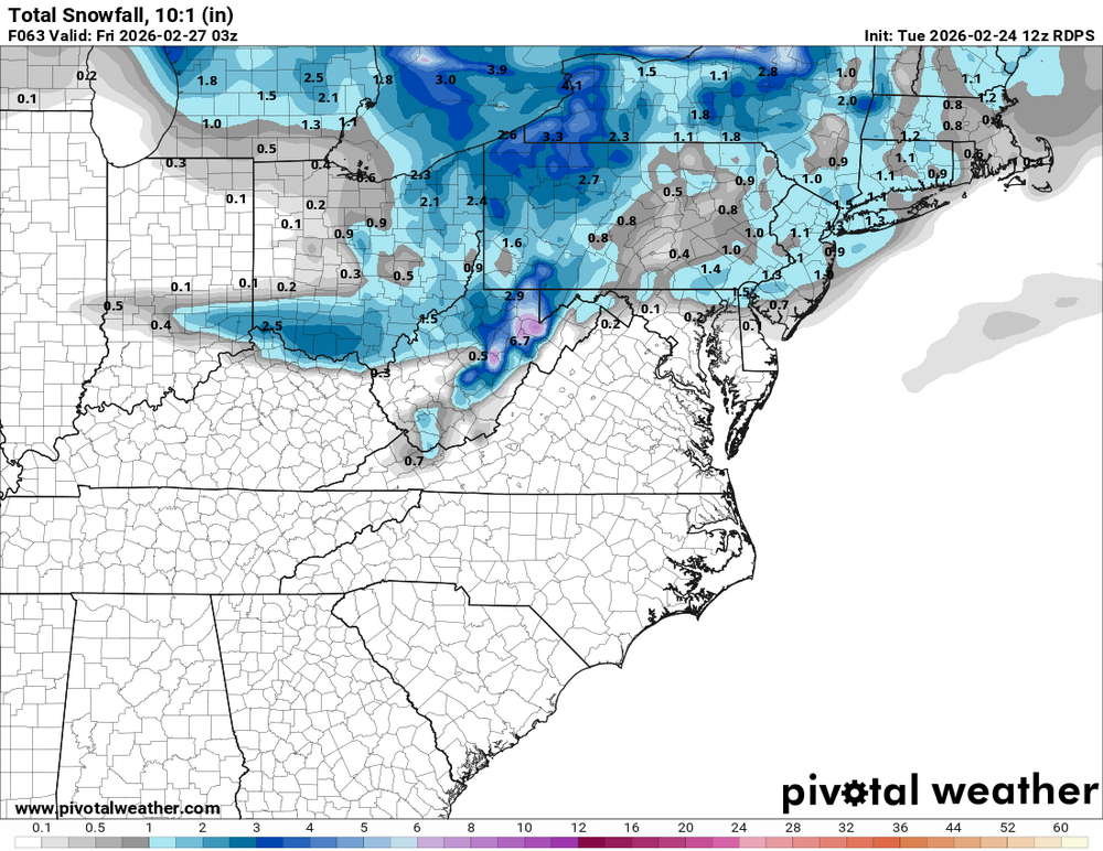
NAM’s a step closer. Verbatim it gives a dusting to Delmarva. But in the leadup, you can see how the flow is trending over the last 3 runs: See the little shortwave getting more emphasis to our west. If this is gonna work at all, need to get that to be stronger but not too strong. NAM 3km had similar changes but no pity flakes.
-
Really need something like the RRFS (both the standard and the MPAS) look but south a bit to get much of a win south of the M/D. So I’m not optimistic given my massive skepticism of them at this range! But at least it seems like we’re not trending even more POS squashed at 12z.
-
RGEM with basically an M/D line and no one else event lol. At least it was better than 06z.
-
Slower and slightly more amped was basically 06z GFS lol so fingers crossed something like that happens. I think that's a reasonable ceiling for the setup barring some sort of change up top in the short term that makes us verify notably colder.
-
Hmmm. Snow verbatim but it came quicker. Wanted to see it move back instead and fall more after dark. I think we in the lowlands really need a late in the day or ideally nighttime passage to be in the game. But maybe we can eat away a little at the projected warmth and make some day snow work.
-
The February 22-23 Late Season Miracle: JV Disco/Banter Thread
baltosquid replied to bncho's topic in Mid Atlantic
Winter wonderland type look. Hopefully we get a widespread look like that sometime. The paste has a way of wrapping things around with snow that’s so pretty, while powder sits on top. -
Feb 22nd/23rd "There's no way..." Obs Thread
baltosquid replied to Maestrobjwa's topic in Mid Atlantic
combo of ground warmth and moisture? Feels like snow was just getting swallowed by puddles as the soil was so saturated already from the snowcrete melt, prior rains and opening rain from this storm. Also probably made the ground temps way more stubborn due to the moisture content. At least that’s my guess. -
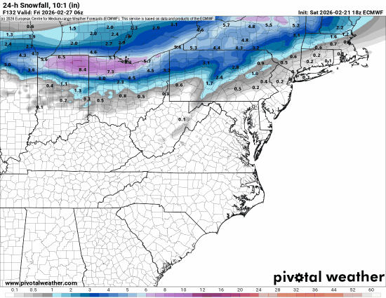
FWIW euro ai came south a bit but it’s faster than other guidance and it is during the day. May have worked out south of the M/D if it happened 6-12 hours later, and it is by a bit the fastest guidance right now it seems. edit: actually it’s about the same result, but marginally better look at 540. Just need some better timing and a little colder. Confidence in this is low here, screams something that will be for NW
-
Gosh, please. Really seems like it could come down to overnight vs day passage.
-
Feb 22nd/23rd "There's no way..." Obs Thread
baltosquid replied to Maestrobjwa's topic in Mid Atlantic
Looking at the radar, that one overnight band (late inverted trough jog? Or just a lucky band thrown back to us) was probably what finally broke the coating barrier we’d been stuck at. Damn it makes me wish that low could have done anything but just turbo scoot its way out east. A few more bands like that would have made a big difference here. -
Feb 22nd/23rd "There's no way..." Obs Thread
baltosquid replied to Maestrobjwa's topic in Mid Atlantic
Deck in the alley probably has about an inch and change. Some less occluded areas may push 2? Still some light snow but accumulations probably cutoff shortly with the sun. Shame we couldn’t get more; the paste we do have here looks nice but just not deep enough to cover everything. -
Feb 22nd/23rd "There's no way..." Obs Thread
baltosquid replied to Maestrobjwa's topic in Mid Atlantic
Yeah I thought to myself while walking my dog that it felt closer to walking in the rain than anything, just so wet. -
The February 22-23 Late Season Miracle: JV Disco/Banter Thread
baltosquid replied to bncho's topic in Mid Atlantic
I'd settle for just not jacking... that blue area's a good bit worse than not jacking unfortunately, especially with UHI. It is beautiful though. Bittersweet. Says a lot about the Mid Atlantic for that beauty to end up the way it does in some of our locales. -
The February 22-23 Late Season Miracle: JV Disco/Banter Thread
baltosquid replied to bncho's topic in Mid Atlantic
Same. I am skeptical we get much measurable stuff period, pavement or not. -
Feb 22nd/23rd "There's no way..." Obs Thread
baltosquid replied to Maestrobjwa's topic in Mid Atlantic
Walked the dog. Slushy coating on grass and other amenable surfaces. Light snow, a bit breezy. At times, light-moderate. Never really got true heavy snow here unfortunately. At this point, 2-4" seems too high now. T-2" more like. We'll see in the morning. One day Baltimore will get the goods without complications... one day. -
Case in point, the 18z euro just suppressed it to death.
-
Feb 22nd/23rd "There's no way..." Obs Thread
baltosquid replied to Maestrobjwa's topic in Mid Atlantic
Car topper achieved….. -
Feb 22nd/23rd "There's no way..." Obs Thread
baltosquid replied to Maestrobjwa's topic in Mid Atlantic
Zero accumulation so far in Canton.


