
.jpeg.fb71a75fc71475b59e72598d4a9a6f88.jpeg)
TJW014
-
Posts
1,082 -
Joined
-
Last visited
Content Type
Profiles
Blogs
Forums
American Weather
Media Demo
Store
Gallery
Everything posted by TJW014
-
I think the biggest uncertainty we're going to have with this system is the energy coming from northern Canada. That has a lot to interact with over the next few days as it does a 360 degree loop over James Bay.
-
The signal is there, and there’s lots of model agreement on a potential Miller A. That's all I really care about until we get to Wednesday. Then we can start ironing out the smaller details (placement, strength, etc)
-
Times like these are when owning a 4WD vehicle is worth the 13 mpg I get year round. My winch and tow strap were busy yanking plowed in cars throughout the neighborhood. Also had to winch my brother's car out of the driveway at 4:30 this morning so he could make it to the police academy. Currently out on the gas golf cart "plowing" (I strapped a shovel to the front) the sidewalks open.
-
7 days out and looks almost perfect. That means this will either be a cutter to the Great Lakes, or snow doesn't make it north of Richmond
-
I feel like some of these snowfall reports, especially public ones may be too high and too low. A lot of drifting took place. I have spots in my yard with drifts knee deep, and spots with bare ground.
-
Got more from December 14. 8" vs 6.5". That was all snow, easy to clear the roads, cars, driveways. Not a fan of these snow to mix events.
-
Right along the bayfont. Not as powdery this way.
-
Transitioning to freezing rain. 6" OTG.
-
5.5". Sleet beginning to mix in.
-
3.5" as of 9:45. Temp up to 30.
-
Incredible not even half that on the other side of town.
-
1". So far not impressed with rates here. Temp up to 24.
-
.thumb.jpeg.f5c6ba9d911ec96b3b124f8606aee58e.jpeg)
Extreme Cold, Snow & Sleet: SECS 1/24 - 1/26
TJW014 replied to TriPol's topic in New York City Metro
Last call. Zero changes to the map from yesterday afternoon. Let's see how it goes...
-
Extreme Cold, Snow & Sleet: SECS 1/24 - 1/26
TJW014 replied to TriPol's topic in New York City Metro
Updated map. Will this pan out? No clue, but that's why I'm not a met. Some minor tweaks from the last one, and unless we see major trends within the next 24 hours, I don't think I'll make any adjustments. I guess you could call it a near worse-case scenario but I'm sticking to a lower/conservative side. I think the mixing line makes it up to CT, then following just north/west of the Fall Line. ENE winds will bring a period of rain to coastal NJ, keeping totals lower. Freezing rain up to 0.25" possible for inland NJ, south of Raritan Bay. However, if the mixing line quickly retreats, or doesn't even make it that far north/east, totals here will be higher, possibly add 50% to what's projected on the map (not in pink). Areas north/west of Easton, PA - Mahwah, NJ should remain all snow, 12-18" likely, possibly higher amounts in higher elevations.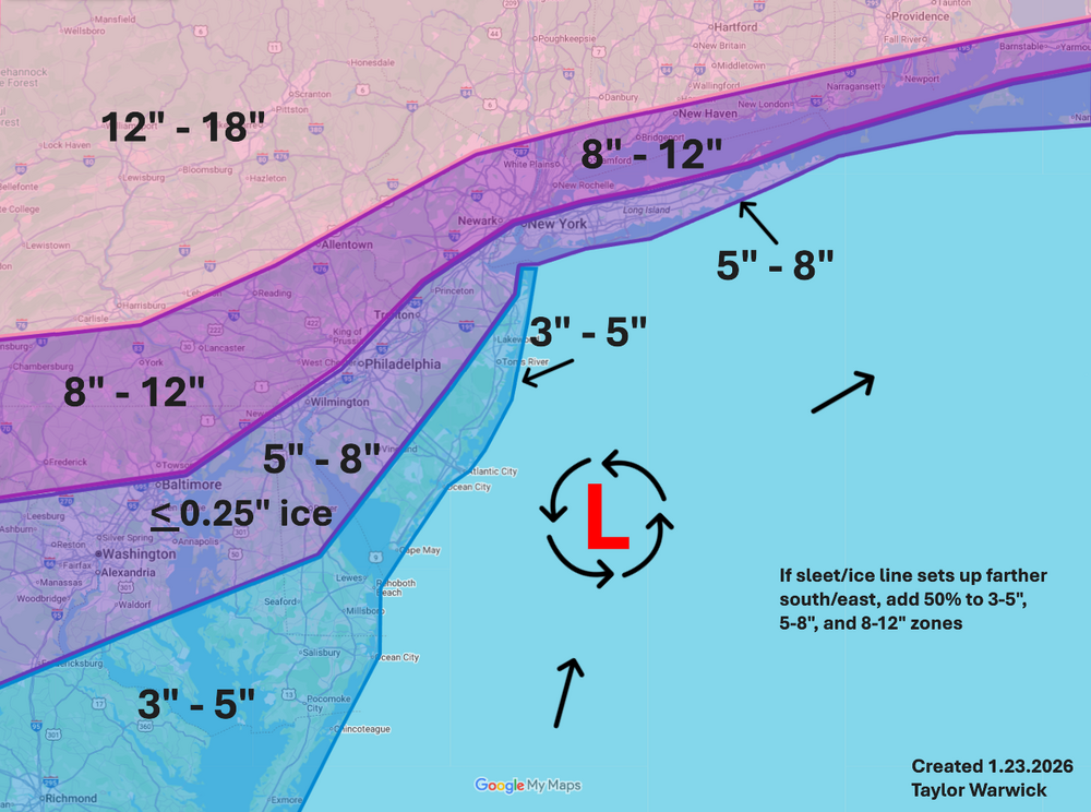
-
Extreme Cold, Snow & Sleet: SECS 1/24 - 1/26
TJW014 replied to TriPol's topic in New York City Metro
WSW issued. Mt Holly still going with 10-15" here. -
Extreme Cold, Snow & Sleet: SECS 1/24 - 1/26
TJW014 replied to TriPol's topic in New York City Metro
GFS yet again remains best case scenario. -
Extreme Cold, Snow & Sleet: SECS 1/24 - 1/26
TJW014 replied to TriPol's topic in New York City Metro
Closing in on 48 hours until go time for some of us. Here's my initial dartboard throw. Never underestimate the jacuzzi that is the Atlantic, even if the buoys are only reading 40. 12 hours of ENE wind, it's going to bring some rain to the coast. Feel free to throw some Oscar Meyers. -
Extreme Cold, Snow & Sleet: SECS 1/24 - 1/26
TJW014 replied to TriPol's topic in New York City Metro
Looks like GFS is still going to be our best bet for big totals. Building an initial snow map. -
Extreme Cold, Snow & Sleet: SECS 1/24 - 1/26
TJW014 replied to TriPol's topic in New York City Metro
True. Could be a reason why many are throwing out maps so early in the game. -
Extreme Cold, Snow & Sleet: SECS 1/24 - 1/26
TJW014 replied to TriPol's topic in New York City Metro
Yup. This was the project a group of us were given for the spring semester. I primarily would like to be focusing on barrier island ecology in the future. -
Extreme Cold, Snow & Sleet: SECS 1/24 - 1/26
TJW014 replied to TriPol's topic in New York City Metro
Less salt, the better. Been running around doing water parameter checks in a bunch of tributaries in Ocean County for a term project. The conductivity and refractometer readings we've been seeing after salt gets laid down is disturbingly high. -
Extreme Cold, Snow & Sleet: SECS 1/24 - 1/26
TJW014 replied to TriPol's topic in New York City Metro
I doubt down here even reaches warning criteria -
Extreme Cold, Snow & Sleet: SECS 1/24 - 1/26
TJW014 replied to TriPol's topic in New York City Metro
Never underestimate the warm nose. It'll rear its ugly head. -
Extreme Cold, Snow & Sleet: SECS 1/24 - 1/26
TJW014 replied to TriPol's topic in New York City Metro
GFS would be perfect here for all of us. Otherwise just let it rain. Don't care if I get 6" from a front thump. If it ends as 3" of slush, what's the fun in that? -
Extreme Cold, Snow & Sleet: SECS 1/24 - 1/26
TJW014 replied to TriPol's topic in New York City Metro
Anybody making snow maps before Friday AM is an idiot. If you want to make note of potential hazards? Sure, but I better not see numbers on a map


