

JakkelWx
-
Posts
3,591 -
Joined
-
Last visited
Content Type
Profiles
Blogs
Forums
American Weather
Media Demo
Store
Gallery
Everything posted by JakkelWx
-
Feb Long Range Discussion (Day 3 and beyond) - MERGED
JakkelWx replied to WinterWxLuvr's topic in Mid Atlantic
-
Jan 31st - 33rd Storm Obs and Disco like it's 1979
JakkelWx replied to Bob Chill's topic in Mid Atlantic
all of us suck for snow. -
Jan 31st - 33rd Storm Obs and Disco like it's 1979
JakkelWx replied to Bob Chill's topic in Mid Atlantic
This is frustrating. Just flip to damn snow soon please. -
Jan 31st - 33rd Storm Obs and Disco like it's 1979
JakkelWx replied to Bob Chill's topic in Mid Atlantic
Yep. That radar sucks. I'm not using it anymore because when it had me under blue it was raining with a slight mix of sleet -
Jan 31st - 33rd Storm Obs and Disco like it's 1979
JakkelWx replied to Bob Chill's topic in Mid Atlantic
925 mb down to -2C -
Jan 31st - 33rd Storm Obs and Disco like it's 1979
JakkelWx replied to Bob Chill's topic in Mid Atlantic
Only a matter of time before we all flip to snow. Probably around noon. -
Jan 31st - 33rd Storm Obs and Disco like it's 1979
JakkelWx replied to Bob Chill's topic in Mid Atlantic
Radar showing that the warm layer is being eroded away: -
Jan 31st - 33rd Storm Obs and Disco like it's 1979
JakkelWx replied to Bob Chill's topic in Mid Atlantic
That's a south shift if I ever seen one on the GFS. -
Jan 31st - 33rd Storm Obs and Disco like it's 1979
JakkelWx replied to Bob Chill's topic in Mid Atlantic
I can tell the column is crashing on radar. I can see splotches of blue over Centreville MD, eastern shore. -
Jan 31st - 33rd Storm Obs and Disco like it's 1979
JakkelWx replied to Bob Chill's topic in Mid Atlantic
The radar looks anemic to my east. -
Jan 31st - 33rd Storm Obs and Disco like it's 1979
JakkelWx replied to Bob Chill's topic in Mid Atlantic
The 2C 850 shifted from Goldsboro MD to Goldsboro MD -
Feb Long Range Discussion (Day 3 and beyond) - MERGED
JakkelWx replied to WinterWxLuvr's topic in Mid Atlantic
That's just the general pattern going forward, and yes it does look cold and dry somewhat but the mean skews/washes out any PNA spike or brief relaxation in the block. The biggest plus in that map is we will actually have a real cold air source. It's game on essentially -
Feb Long Range Discussion (Day 3 and beyond) - MERGED
JakkelWx replied to WinterWxLuvr's topic in Mid Atlantic
Pure model porn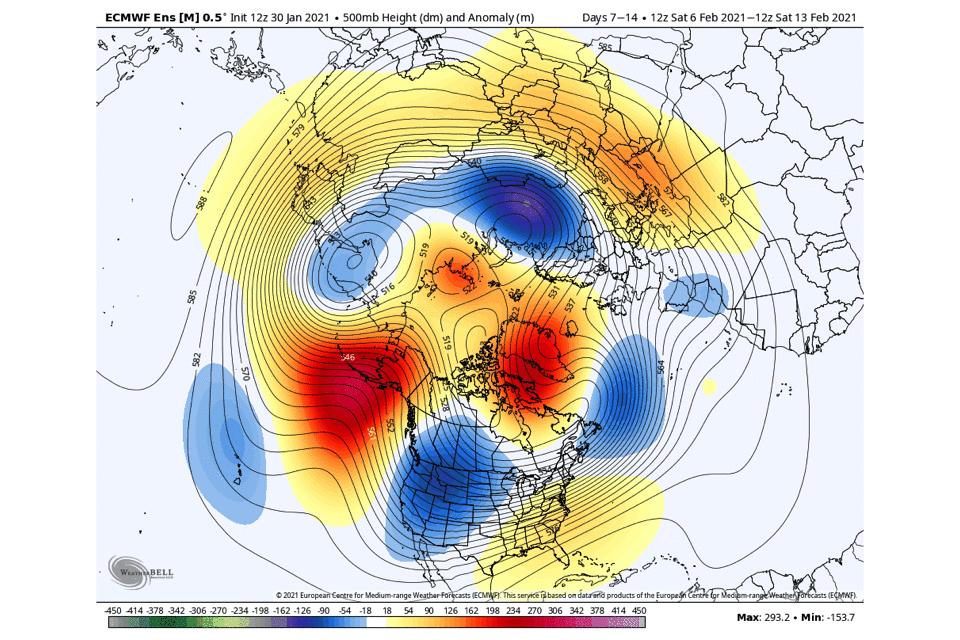
-
Feb Long Range Discussion (Day 3 and beyond) - MERGED
JakkelWx replied to WinterWxLuvr's topic in Mid Atlantic
That's a pretty good signal. Just need a high overhead and not a GL low. -
Jan 31st - 33rd Storm Obs and Disco like it's 1979
JakkelWx replied to Bob Chill's topic in Mid Atlantic
Latest mesoanalysis has the 925 0C line right over my house and has shifted SE since earlier. 850s however are still about 3C. Probably explains the sleet. -
Jan 31st - 33rd Storm Obs and Disco like it's 1979
JakkelWx replied to Bob Chill's topic in Mid Atlantic
Temp down to 35 but I can throw a rock into 32 degree temps. Sleet mixed with rain now -
Jan 31st - 33rd Storm Obs and Disco like it's 1979
JakkelWx replied to Bob Chill's topic in Mid Atlantic
850s are down to 2C here, they should cool down even further and possibly flip back to snow around or before noon if precip is heavy enuf -
Feb Long Range Discussion (Day 3 and beyond) - MERGED
JakkelWx replied to WinterWxLuvr's topic in Mid Atlantic
We have this pattern coming up from D6-D16. -
Jan 31st - 33rd Storm Obs and Disco like it's 1979
JakkelWx replied to Bob Chill's topic in Mid Atlantic
How are we going to see only an inch when it's going to be snowing starting 1 PM today thru early morning Wednesday? We're likely going to see a few inches at least. That would be a pretty big bust to only see an inch of snow when we are 50 miles from a low that stalls for almost two days straight. -
Jan 31st - 33rd Storm Obs and Disco like it's 1979
JakkelWx replied to Bob Chill's topic in Mid Atlantic
I'll take the 3k NAM depiction of 12 inches from backside snow -
Jan 31st - 33rd Storm Obs and Disco like it's 1979
JakkelWx replied to Bob Chill's topic in Mid Atlantic
Tomorrow it's gonna be Jan 32nd! -
Jan 31st - 33rd Storm Obs and Disco like it's 1979
JakkelWx replied to Bob Chill's topic in Mid Atlantic
Based on the NAM improvements, I still like a general additional 1-2 inches on the backside, anything more is a bonus. Should be snow TV all day Tuesday -
Jan 31st - 33rd Storm Obs and Disco like it's 1979
JakkelWx replied to Bob Chill's topic in Mid Atlantic
NAM improved -
Jan 31st - 33rd Storm Obs and Disco like it's 1979
JakkelWx replied to Bob Chill's topic in Mid Atlantic
Is suppression still a risk for this storm? -
Jan 31st - 33rd Storm Obs and Disco like it's 1979
JakkelWx replied to Bob Chill's topic in Mid Atlantic


