Joshb32689
-
Posts
50 -
Joined
-
Last visited
Content Type
Profiles
Blogs
Forums
American Weather
Media Demo
Store
Gallery
Everything posted by Joshb32689
-
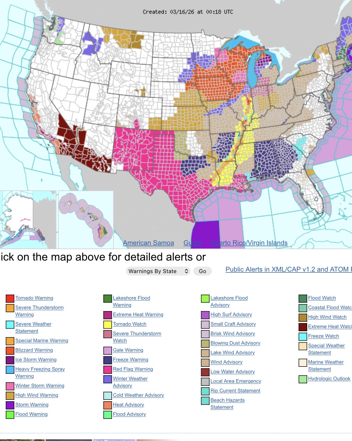
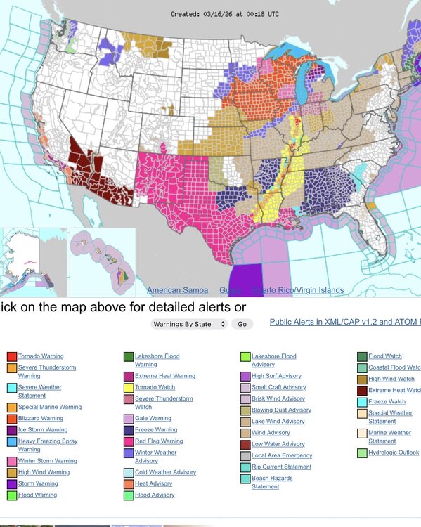
Quite the assortment of hazards across the country.
- 1,093 replies
-
- 3
-

-
- severe
- thunderstorms
- (and 1 more)
-
E PA/NJ/DE Spring 2026 Obs/Discussion
Joshb32689 replied to PhiEaglesfan712's topic in Philadelphia Region
Had some good sleet coming down for a bit outside of Coatesville. Lighter precip moving in, mixed back to rain. 39° F One of the wilder variations in temps and weather I’ve seen in awhile. 82 to sleet in the span of what, 36-48 hours? see if we can manage a little snow accumulation later -
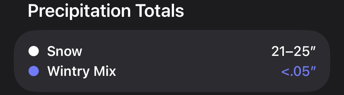
4” just north of Coatesville
-
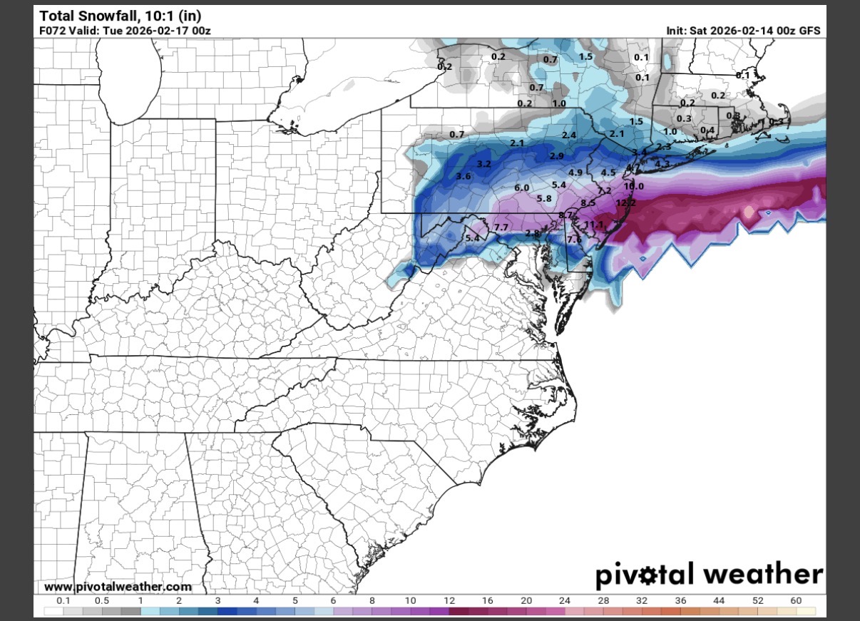
For the trolls (Mickey) and those living & dying by each hour model runs and worried about the trend (me) - HRRR & RAP stopped the bleed of the south and east trend with ticks back NW. Wet snow mixing in for the past 20 minutes in the Coatesville area. Slightly trimmed my expectations but still looking forward to a great storm.
-
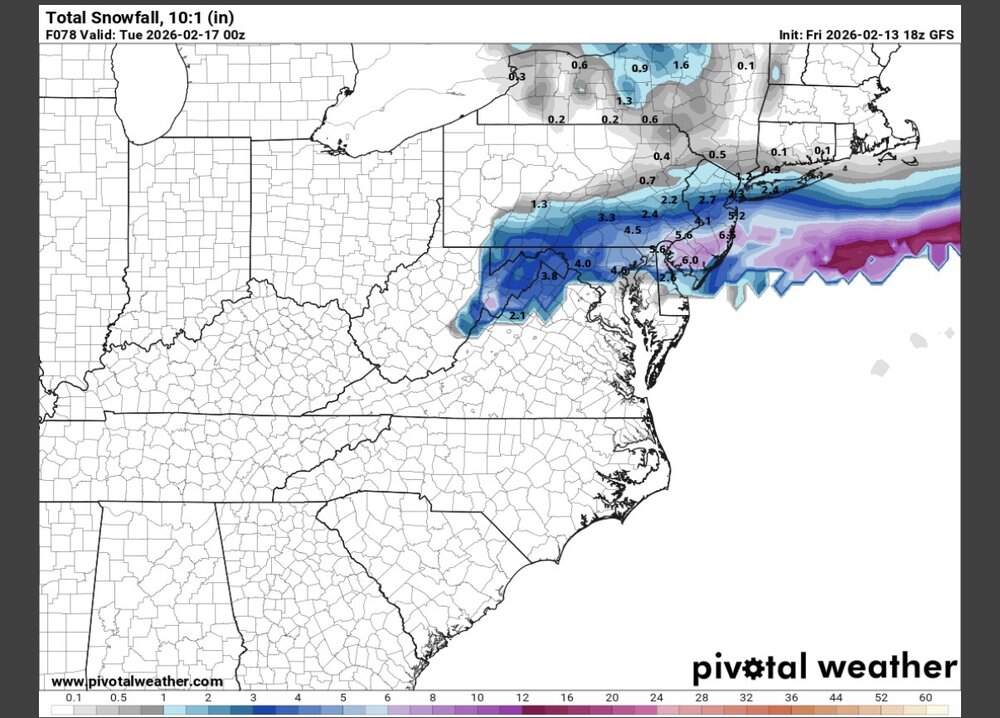
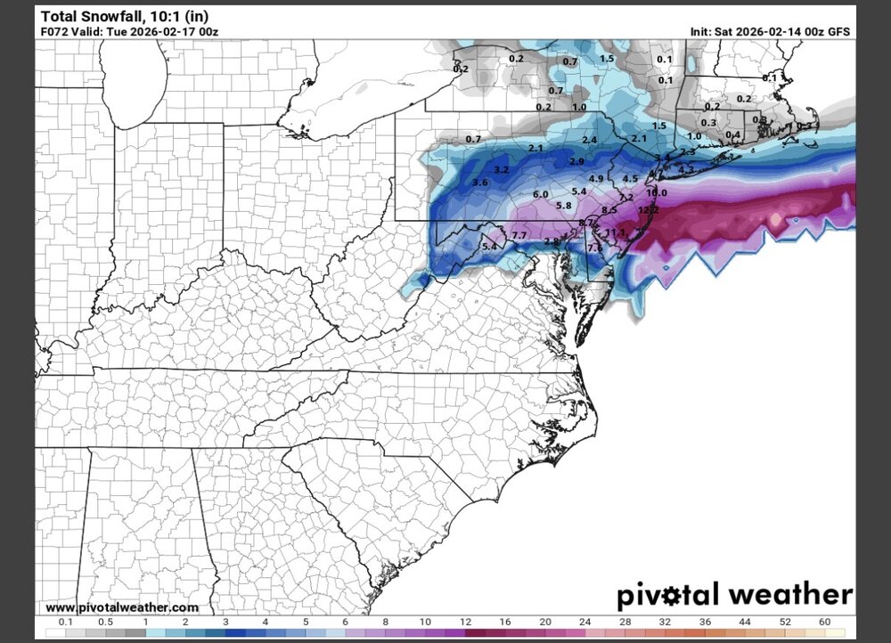
MQS range between HRRR and NAM is identical to our upgraded winter storm warning of 16-22”. Sounds like a solid call at the moment. Now just gotta pull the trigger on the blizzard warning - make it official. URGENT - WINTER WEATHER MESSAGE National Weather Service Mount Holly NJ 256 AM EST Sun Feb 22 2026 ...POTENTIALLY HISTORIC WINTER STORM WILL IMPACT THE REGION THROUGH MONDAY... .A major winter storm is expected to develop today, impacting the region with very heavy, crippling snowfall and areas of blizzard conditions. Precipitation will develop today, changing to all snow this afternoon and evening. The most severe conditions and heaviest snowfall will occur tonight, with snow gradually tapering off during the daytime Monday. Record breaking snowfall totals are possible. Western Chester-Eastern Chester-Western Montgomery- Including the cities of Oxford, Honey Brook, West Chester, Collegeville, Pottstown, and Kennett Square 256 AM EST Sun Feb 22 2026 ...WINTER STORM WARNING REMAINS IN EFFECT FROM 7 AM THIS MORNING TO 6 PM EST MONDAY... * WHAT...Heavy snow expected. Total snow accumulations between 16 and 22 inches. Winds gusting as high as 40 mph.
-
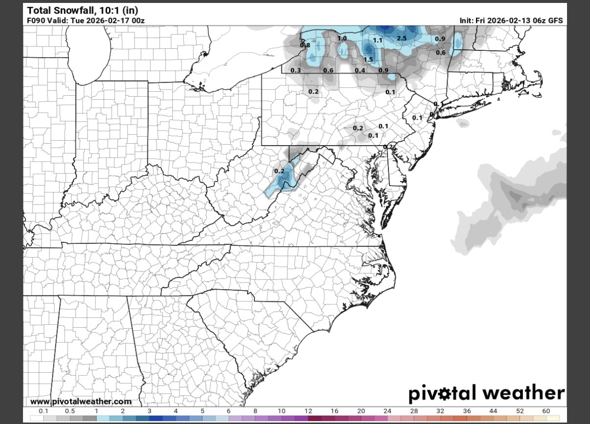
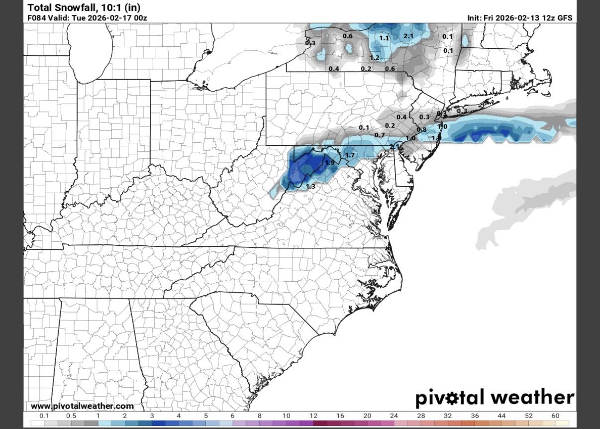
Where does one obtain the GEFS individuals? Would love to see some of those tucked solutions
-
E PA/NJ/DE Winter 2025-26 Obs/Discussion
Joshb32689 replied to LVblizzard's topic in Philadelphia Region
This seems far from settled 0z Euro vs 6z NAM
-
E PA/NJ/DE Winter 2025-26 Obs/Discussion
Joshb32689 replied to LVblizzard's topic in Philadelphia Region
Quite the trend from 1am - 7pm. South Jersey went from 0 to over a foot in some spots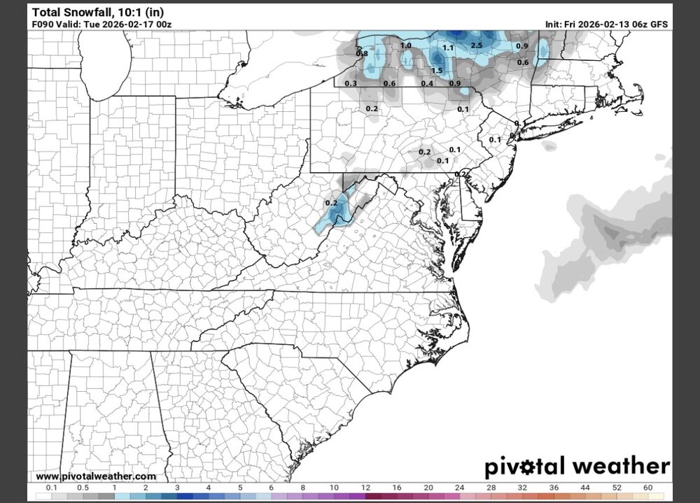

-
E PA/NJ/DE Winter 2025-26 Obs/Discussion
Joshb32689 replied to LVblizzard's topic in Philadelphia Region
https://x.com/WeatherProf/status/2022438348405481832 I don’t know what the GRAF is but damn -
January 24-26: Miracle or Mirage JV/Banter Thread!
Joshb32689 replied to SnowenOutThere's topic in Mid Atlantic
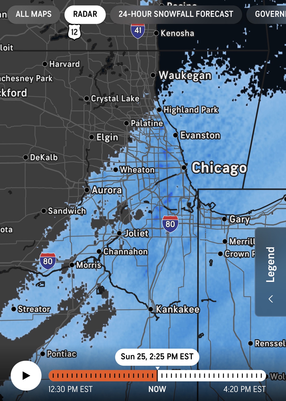
Meanwhile in Chicago they’re piling up lake effect
-
January 25-26 Winter Storm Potential
Joshb32689 replied to Ralph Wiggum's topic in Philadelphia Region
western Chester County: WSW went from 6-10 to 7-13 -
January 25-26 Winter Storm Potential
Joshb32689 replied to Ralph Wiggum's topic in Philadelphia Region
Outside of Coatesville - north of the valley. It keeps ticking up for us. The amount of flack they should take “if” they get this wrong. They’re a $3 trillion company.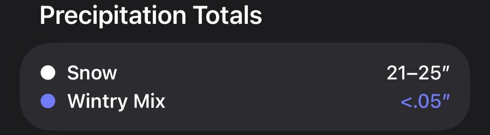
-
Jan 24-26 Weekend Snow and Sleetfest Model Thread Part Tres
Joshb32689 replied to H2O's topic in Mid Atlantic
-
January 24-26: Miracle or Mirage JV/Banter Thread!
Joshb32689 replied to SnowenOutThere's topic in Mid Atlantic
Would someone be so kind as to explain what it is we are rooting for as these new models are coming in - More/less confluence? More/less spacing? Phasing? I can’t tell if I should be excited or disappointed -
January 24-26: Miracle or Mirage JV/Banter Thread!
Joshb32689 replied to SnowenOutThere's topic in Mid Atlantic
Bring us home Big Nacho -
Saturday night/Sunday 12/13-12/14 Jawn
Joshb32689 replied to Ralph Wiggum's topic in Philadelphia Region
My hopping around between Delco and Chesco over the last few years means this might be the first >3”, clean snowstorm I’ve seen since at least 2019. Bring itttttttttttt. Give me that high end in the Coatesville area please
-
E PA/NJ/DE Summer 2025 Obs/Discussion
Joshb32689 replied to Hurricane Agnes's topic in Philadelphia Region
-
E PA/NJ/DE Summer 2025 Obs/Discussion
Joshb32689 replied to Hurricane Agnes's topic in Philadelphia Region
Coatesville area is going to be pushing Manheim totals soon with the way this radar is lining up. -
E PA/NJ/DE Summer 2025 Obs/Discussion
Joshb32689 replied to Hurricane Agnes's topic in Philadelphia Region
This thunder coming in to Coatesville…hearing for a good 20 mins now from far away is unreal. Just a constant rumble getting louder and louder. I’ve never heard anything like it. -
E PA/NJ/DE Spring 2025 Obs/Discussion
Joshb32689 replied to PhiEaglesfan712's topic in Philadelphia Region
Good morning 2 hours early to all. Holy lightning in the Coatesville area -
Moments likes this remind me that non-weather people really don’t like the word sleet. My husband has stopped calling it hail… he’s now just calling it ice.
-
Sounds like a decent mix between freezing rain and sleet, primarily freezing rain at the moment? Between Coatesville and Glenmoore. Very slippery
-
Hate to be in Poconal for this one. Have to imagine this puts them back to zero for the season.
-
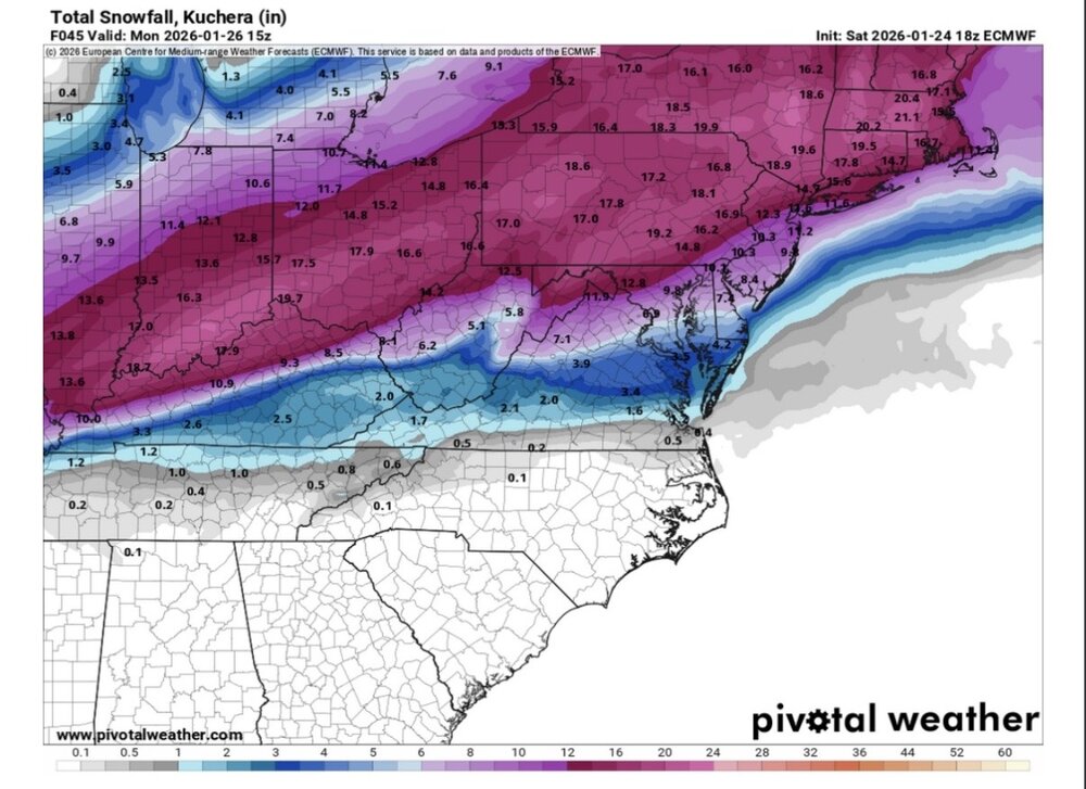
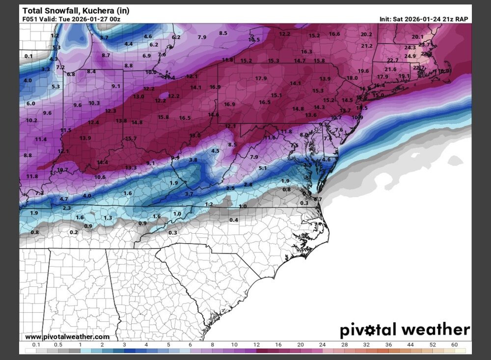
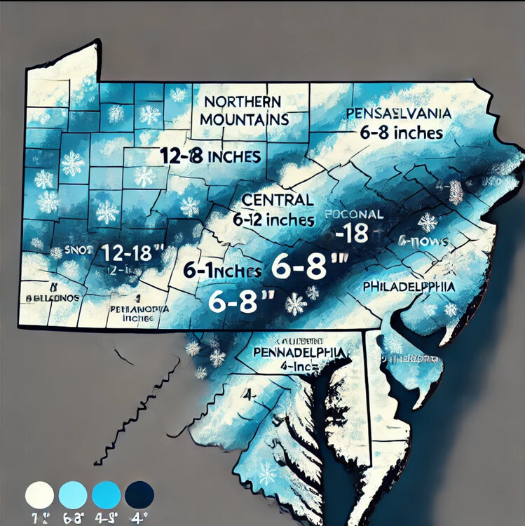
I sent ChatGPT these 2 images… I asked it to make me a forecast snow accumulation map. Here’s what we’re looking at on the ChatGPT model. This is also my official forecast.
-
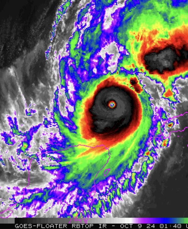
Are we approaching the skull phase of the storm?