BhamParker
-
Posts
298 -
Joined
-
Last visited
Content Type
Profiles
Blogs
Forums
American Weather
Media Demo
Store
Gallery
Everything posted by BhamParker
-

2021-2022 Fall/Winter Mountains Thread
BhamParker replied to BlueRidgeFolklore's topic in Southeastern States
GFS out to 72 seems to have better thermals to snow for mountains. -
2021-2022 Fall/Winter Mountains Thread
BhamParker replied to BlueRidgeFolklore's topic in Southeastern States
That would be some insane rates on the 00z GFS. Thundersnow?
-
2021-2022 Fall/Winter Mountains Thread
BhamParker replied to BlueRidgeFolklore's topic in Southeastern States
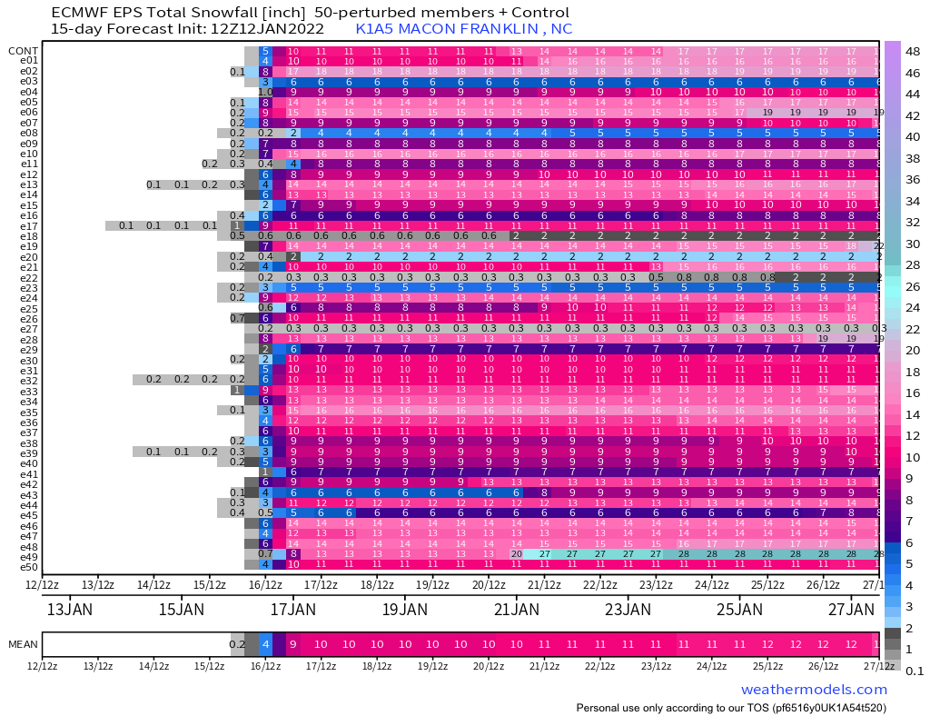
I saw that. Crazy to think it drops that much with essentially 12 more hours or so of snow for those areas. I have been fired up about this chase, but its honestly getting a little nerve wracking now with how big it could be. I have never seen more than 7 inches in person before. I just absolutely do not want to lose power and really hope we can make it out at some point monday. -
2021-2022 Fall/Winter Mountains Thread
BhamParker replied to BlueRidgeFolklore's topic in Southeastern States
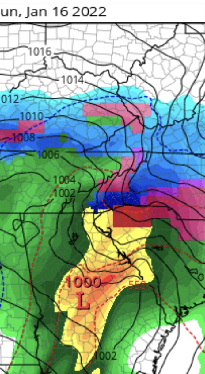
Wow! 12z EPS charts for around highlands, cashiers, lake toxaway.
-
2021-2022 Fall/Winter Mountains Thread
BhamParker replied to BlueRidgeFolklore's topic in Southeastern States
I don’t know if I’m mentally ready for what’s coming. I’ve chased many to gatlinburg/Maggie valley, but they have all ranged from 2-6 inches mainly. This one will be memorable. Looking forward to sharing it with my family and my first born 9 month old son. -
2021-2022 Fall/Winter Mountains Thread
BhamParker replied to BlueRidgeFolklore's topic in Southeastern States
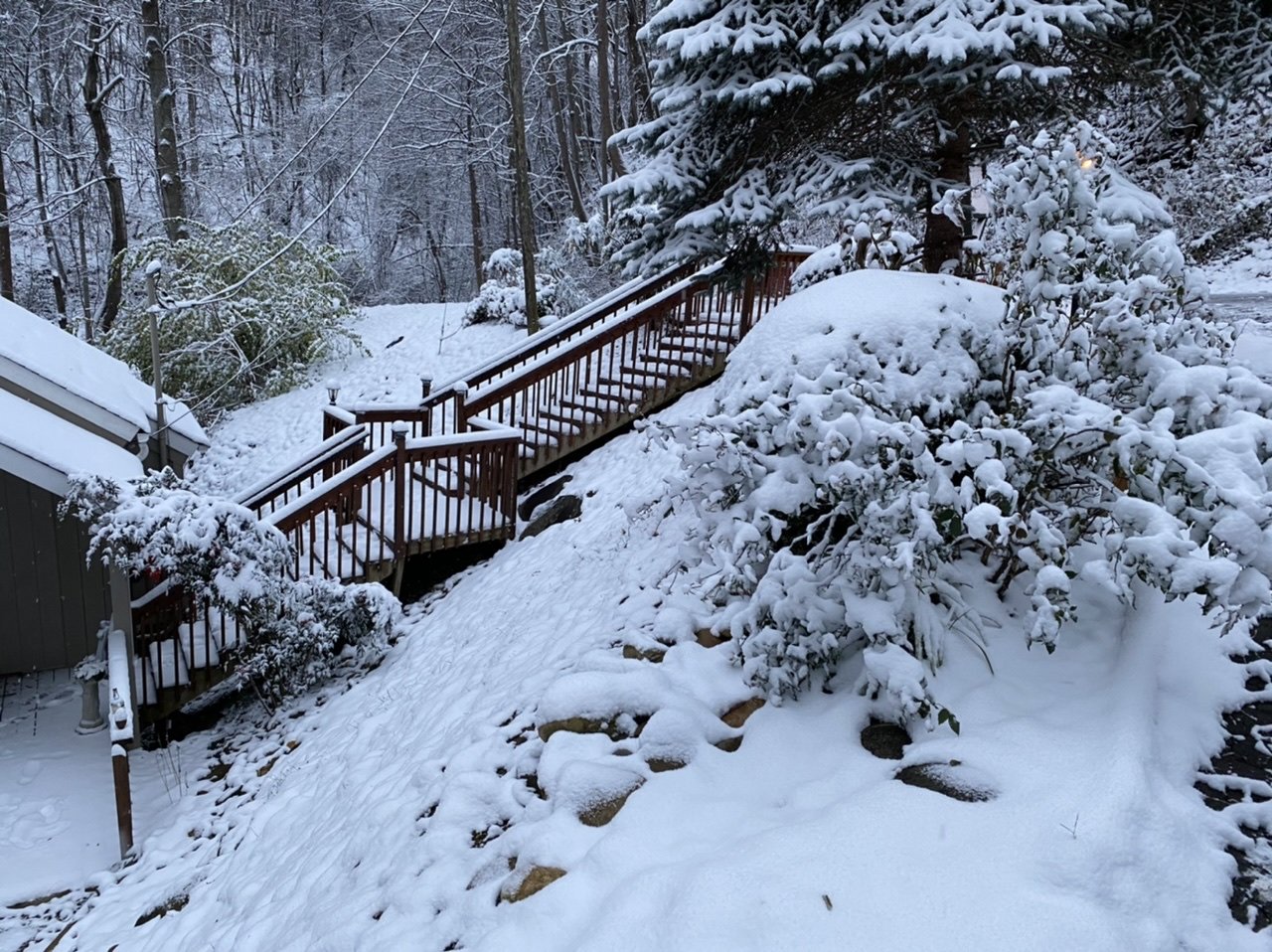
I'll be making the trip to Lake Toxaway North Carolina this weekend for the upcoming storm. This will be our first trip to this area and it looks beautiful. Hope to give yall some good pictures. -
How much did you end up with? Enjoy reading all yalls reports! I was going to make it up to gatlinburg to chase from down here from Birmingham, but couldn’t make it. Hope the pattern allows some more good setups this month and into February.
-
Dandridge Dollop 12/24/20 Storm Thread (Winter Wonderland)
BhamParker replied to AMZ8990's topic in Tennessee Valley
I am living vicariously through this thread. Pulling hard for all you Tennessee folks. It’s 35 in Birmingham with a stiff and steady wind. No ground truth to the snow on radar unfortunately as of yet. I sure would love to be in a cabin tonight with some elevation. Y’all have a Merry Christmas and reel this one in! I’ll be back for another storm before winter is finished.- 847 replies
-
- 9
-

-
- cold temperatures
- snow
- (and 8 more)
-
Oak Moon Upslope/ Upper Low Storm Obs
BhamParker replied to Holston_River_Rambler's topic in Tennessee Valley
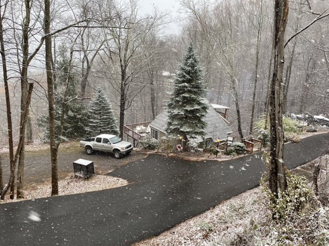
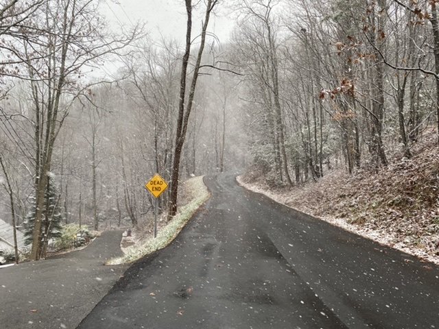
We just got back to Birmingham! It was a little sketchy getting out of the driveway but all the roads in and around ski mountain road were just slushy. The highest measurement I got was 4 inches on the porch. It was a beautiful snow and a lot more fell than actually accumulated. It took awhile to get going and it snowed lightly all night last night. I bet if it were later in the season it would have been more. It also was coming down great as we were leaving all the way past pigeon forge and close to Knoxville. Wouldn’t be surprised if the cabin picked up a little more after we left. We will be back again soon!
- 300 replies
-
- 11
-
-
- upslope snow
- upper level disturbance
- (and 3 more)
-
Oak Moon Upslope/ Upper Low Storm Obs
BhamParker replied to Holston_River_Rambler's topic in Tennessee Valley
GFS, RGEM, and NAM all say more NW flow snow tonight until daybreak. The HRRR is not currently matching up with what’s on radar.- 300 replies
-
- 1
-
-
- upslope snow
- upper level disturbance
- (and 3 more)
-
Oak Moon Upslope/ Upper Low Storm Obs
BhamParker replied to Holston_River_Rambler's topic in Tennessee Valley
Thats exactly the type flakes we are getting here right now. Reminds me of the flakes I saw fall for the Christmas 2010 storm on Christmas night and then I woke up to like 4 more inches of snow. Maybe it'll roll for awhile and tack on some more.- 300 replies
-
- 2
-
-
- upslope snow
- upper level disturbance
- (and 3 more)
-
Oak Moon Upslope/ Upper Low Storm Obs
BhamParker replied to Holston_River_Rambler's topic in Tennessee Valley
Rates are picking back up here, maybe its not over here. Latest HRRR still shows plenty of NW flow support.- 300 replies
-
- 2
-
-
- upslope snow
- upper level disturbance
- (and 3 more)
-
Oak Moon Upslope/ Upper Low Storm Obs
BhamParker replied to Holston_River_Rambler's topic in Tennessee Valley
Returns are really starting to decrease at the moment. Probably have 3-4 inches right now. The wind has blown a lot of it around.- 300 replies
-
- 3
-
-
- upslope snow
- upper level disturbance
- (and 3 more)
-
Oak Moon Upslope/ Upper Low Storm Obs
BhamParker replied to Holston_River_Rambler's topic in Tennessee Valley
I sure hope we can make it down tomorrow. We are set to check out tomorrow and have to be out by 11. I know in the past they've typically plowed/salted/taken good care of the roads around these cabins, but I am definitely a little concerned about it. Hopefully all will be okay in the morning. I have a tacoma truck, but do not own chains. -
Oak Moon Upslope/ Upper Low Storm Obs
BhamParker replied to Holston_River_Rambler's topic in Tennessee Valley
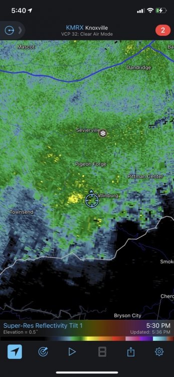
Y’all the yellow returns just keep coming snd the wind is howling! You can’t even see the lights of downtown gatlinburg. I know the weather channel app is crap, but they’ve even upped it to 5-8 inches tonight. If these heavy returns continue then I think those amounts may be possible- 300 replies
-
- 10
-
-

-
- upslope snow
- upper level disturbance
- (and 3 more)
-
Oak Moon Upslope/ Upper Low Storm Obs
BhamParker replied to Holston_River_Rambler's topic in Tennessee Valley
It’s going crazy here y’all- 300 replies
-
- 4
-
-
- upslope snow
- upper level disturbance
- (and 3 more)
-
Oak Moon Upslope/ Upper Low Storm Obs
BhamParker replied to Holston_River_Rambler's topic in Tennessee Valley
Down right heavy snow right now!- 300 replies
-
- 5
-
-
- upslope snow
- upper level disturbance
- (and 3 more)
-
Oak Moon Upslope/ Upper Low Storm Obs
BhamParker replied to Holston_River_Rambler's topic in Tennessee Valley
- 300 replies
-
- 6
-

-
-
- upslope snow
- upper level disturbance
- (and 3 more)
-
Oak Moon Upslope/ Upper Low Storm Obs
BhamParker replied to Holston_River_Rambler's topic in Tennessee Valley
Things are changing around here really quick. Going to be an exciting night!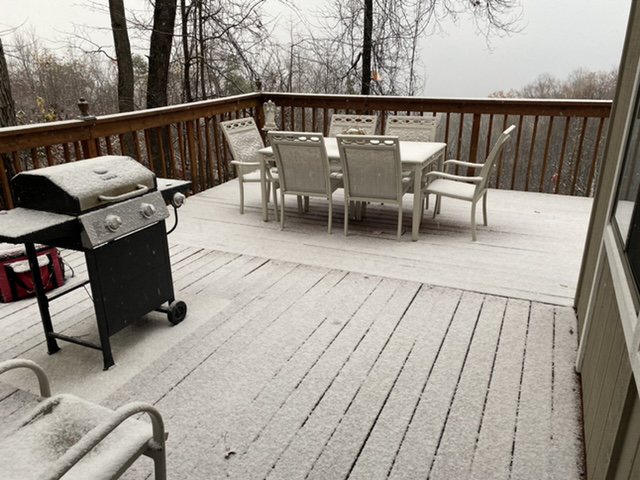
- 300 replies
-
- 5
-
-
- upslope snow
- upper level disturbance
- (and 3 more)
-
Oak Moon Upslope/ Upper Low Storm Obs
BhamParker replied to Holston_River_Rambler's topic in Tennessee Valley
I feel like each HRRR run just keeps getting better and better. -
Oak Moon Upslope/ Upper Low Storm Obs
BhamParker replied to Holston_River_Rambler's topic in Tennessee Valley
From MRX afternoon disco From MRX afternoon disco... The higher elevations of the Appalachians will see the highest totals with 4-8 inches across the winter storm warning. The HREF along with other guidance continues to paint 6-12 inches across the highest peaks, above 5000 feet. Precipitation will quickly end from west to east overnight and by 12Z Tuesday expect only the higher elevations to see remaining snow. If I see 6+ then I will probably faint.- 300 replies
-
- 2
-
-
- upslope snow
- upper level disturbance
- (and 3 more)
-
Oak Moon Upslope/ Upper Low Storm Obs
BhamParker replied to Holston_River_Rambler's topic in Tennessee Valley
I have a feeling when that sun goes down and that heavy band after dark gets going that it’s gonna stack up quick with temps in the mid to low 20s.- 300 replies
-
- 4
-
-
-
- upslope snow
- upper level disturbance
- (and 3 more)
-
Oak Moon Upslope/ Upper Low Storm Obs
BhamParker replied to Holston_River_Rambler's topic in Tennessee Valley
Trees are getting white in a hurry, this place will look like a winter wonderland in the morning- 300 replies
-
- 4
-
-
- upslope snow
- upper level disturbance
- (and 3 more)
-
Oak Moon Upslope/ Upper Low Storm Obs
BhamParker replied to Holston_River_Rambler's topic in Tennessee Valley
18z 3K NAM looked amazing for the mountains. Shows some pretty heavy stuff for 8-10 hours. It has really gotten cold with the snow falling!- 300 replies
-
- 1
-
-
- upslope snow
- upper level disturbance
- (and 3 more)
-
Oak Moon Upslope/ Upper Low Storm Obs
BhamParker replied to Holston_River_Rambler's topic in Tennessee Valley
Its ripping pretty good up here now. If this can continue I would expect some accumulating to start soon.- 300 replies
-
- 3
-
-
- upslope snow
- upper level disturbance
- (and 3 more)