Albedoman
-
Posts
1,321 -
Joined
-
Last visited
Content Type
Profiles
Blogs
Forums
American Weather
Media Demo
Store
Gallery
Everything posted by Albedoman
-
Nov 16-18, first measurable snow for the LV this season-- lock it in
- 852 replies
-
- 2
-

-
- hurricane
- tropical storm
- (and 1 more)
-
donut hole right over the LV typical
-
WOW, a truly western USA mountain valley night here for the LV --29 degree low expected with a chance of freezing fog. Do not see that forecast to often here in October let alone before Thanksgiving. The diurnal range is just incredible almost 35 degrees with low dewpoints and low humidities during the day. Highs in the mid 60s from 29 degrees
-
those idiots do not realize that loading up ads significantly slows down my time for looking at the radar and seconds are important. Like everyone else has just said- they are now gone from my viewing. Boy are they stupid.
-
my bad , it should have been Named Hurricane Hermine
- 852 replies
-
- 1
-
-
- hurricane
- tropical storm
- (and 1 more)
-
Hurricane Gaston- first weekend in October Cat 3+ downgraded by the time it hits us will bring us our first biggie rain event here in awhile
- 852 replies
-
- 1
-
-
- hurricane
- tropical storm
- (and 1 more)
-
I agree. That huge low in Alaska is going to bring down some good ole cold fronts in the next few weeks with lows dropping into the 30's. The La Nina pattern is also going to help steer the hurricanes away from our area. The growing season will end early this year. This stubborn pattern creates long duration small accumulations of snow on the ground but constant clippers will keep the snow pack refreshed and cold . I expect the parade to start around Thanksgiving going into December.
- 852 replies
-
- 1
-
-
- hurricane
- tropical storm
- (and 1 more)
-
good, I hope it stays dead. La Nina patterns are not necessarily mild but they are sure the hell less snowy for our area. The Central US (Missouri, Illinois and northern Kentucky) with the Great Lakes area will get pounded (Indiana, Ohio, NW PA and NY) with heavy snow in this pattern. Usually only one or two good snows(8+ in) are typical in our area and they have to be thread the needle type storms Miller B's or over producing Alberta clippers). Snow may start right after Thanksgiving this year but they will 2-4 inch type snows throughout December. Snow cover may be the real issue(long duration) and a prolong cold outbreak for our area maybe the real issue for us. I see no biggies Nor'easters in our future this year as the GOM is shutoff from LP production in this LA Nina crappy pattern for big snowstorms. If the GOM opens up during the winter, we get one but I am not holding my breath..
- 852 replies
-
- 2
-

-
-
- hurricane
- tropical storm
- (and 1 more)
-
This potential (Hurricane Fiona) potential should be taken real seriously. This first look at this storm is almost at the same pressure as Floyd (1999) in almost the same location under similar drier than normal conditions for our area in 1999. https://en.wikipedia.org/wiki/Hurricane_Floyd
- 852 replies
-
- 1
-
-
- hurricane
- tropical storm
- (and 1 more)
-
by the way, the air is so soupy this morning. Its been awhile for these ripe conditions to form but I really think some good boomers will be popping with some squall lines late this afternoon and into the evening. Its been a long time ( since June?) The drought was killed off this weekend and especially after tonight. Too late for the crops though. Really think an east based La Nina will form in mid November and dump on us this year in December with some really cold outbreaks . Snowfall should be average to just above average from the LV to the NW
- 852 replies
-
- 2
-
-
-
- hurricane
- tropical storm
- (and 1 more)
-
This snow measuring device should be called the "the 2001 Bolaris tool" LOL
-
a weenies dream. Sounds like a Ji forecast to me.
-
.25 inch here. Nothing to write home about. Not even close to a drought buster that's for sure.as this this storm is going the same way as the previous rain events this summer. SW to NE flow with the Berlin Wall set up at the Blue Mt range with oour typical donut hole. If the heavy rains down in Md area regenerate overnight, we could see some heavier downpours tonight. Thats are only hope otherwise , the flood watch may be canceled. The worst part, no t- storms.
- 852 replies
-
- 1
-
-
- hurricane
- tropical storm
- (and 1 more)
-
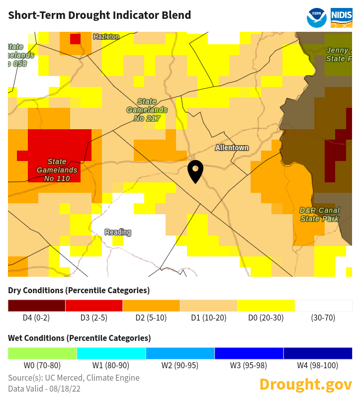
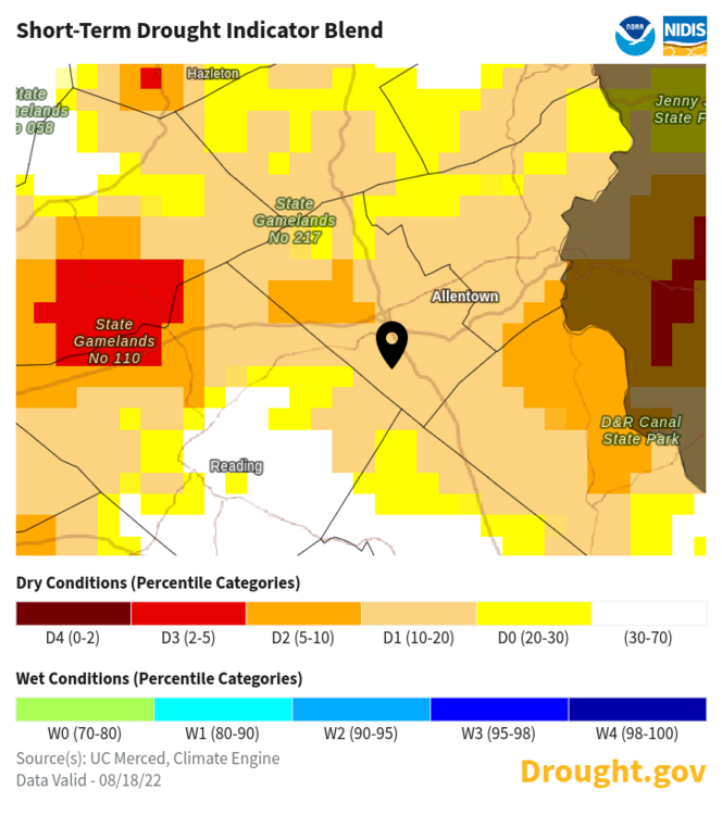
yep. I am waiting for a drought warning to be issued real soon. They waited too long to even issue the drought watch as the stream base flows are becoming a real issue. I expect many non -spring fed streams to be dry by next week in our area like the Jordan Creek. I know many of the posters have been teasing me about me calling for a drought since last spring but unless we get a tropical storm soon, this area's water supply, especially for private wells, are going to become very problematic. I expect well drillers are busier than hell digging deeper wells for residential properties right now.
-
.27 in of rain- the most I will see for another two weeks. The trout streams are getting the butt kicked out of them for thermals. 120 degree water from the street runoff hitting a low base flow spring fed trout stream is killing the fingerlings. This has been happening in the last five minuscule rain events. I really feel another Floyd type of tropical storm is on the horizon by late mid to late September in this weather pattern that will hopefully break this persistent drought. All I can say is the crabgrass and japanese stilt grass love this weather.
-
wam bam thank you mam storm/gust front with a 10 minute downpour coming up. That will be the end of the rain chances for another week as the desert air comes back bigtime. Any rain we get will water the flowers and garden. Thats it . The dead lawn --no hope. The base flows of the local creeks will be in pretty bad shape by next weekend. The heat returns but shorter in duration. The leaves are going to turn brown on the hardier trees now. No fall colors this year for many areas except yellow and brown. I have raked up more leaves in the past week than ever for August that's for sure. I run the lawn mower to mulch the leaves since the lawn is in dormancy
-
popup showers 10% chance of getting one by this evening. All the main t-storm formation is again west of the Alleghenies- will never make it here by nightfall. Like I posted earlier this week , the drought will continue and get worse until a tropical storm breaks this crappy pattern for good and helps pulls down canadian cool air hopefully by the third week in september. Issues to contend with: 1. Leaves are scorched on many trees(sycamores, tulip poplars and maples ) and are falling like it is mid October. The summer web worm is also having a field day in Lehigh County and many walnut trees are becoming defoliated. making more leaves fall. Autumn peak colors will be like crap around here. 2. Stream base flows are falling big time . The 1-2 inch rain early in week helped only to temporarily green the lawns but did absolutely jack crap for the aquifers and stream base flows. 3. Overnight temps are killing us more than the daytime dryness. With no cool nights, we are not reaching the dewpoints and forming moisture on the vegetation and in the air. To make matters worse, the A/C is working overtime because no one can sleep when low temps are between the mid 60's and 70's 4. The current pattern will temporarily break on around Sept 1-2 and we will finally get lows to hit near the dewpoints of 45-50 degrees. But that will be only for a few days and then we are back into the SOS weather pattern.
-
finally a t-storm with lighting --- first one since June to hit me around 6 pm. received a little over an inch in the bucket. This was a million dollar rain for those farmers who got it to keep the corn from spiking and get the soybeans to produce pods again. Drought still not over as this rain was so torrential as it mostly ran off so quickly. Basically, the storm just washed the streets from the dust and debris and soaked the first inch of topsoil. By the end of the week , we will be back to square one with the return of the heat.
-
BS very localized storms in NJ . This picture means absolutely nothing. The rain gauge in Allentown PA must sit under a roof gutter LMAO then. 10-15 miles away from LVIA , places have received less than a quarter inch. Tell that to the farmers in western lehigh County This must be Allentown NJ. https://allentownnj.govoffice3.com/?pri=0
-
yep you are spot on- not forming in the Alleghenies/Valley but over the Blue Mts/Appalachians is always a good sign this early in the afternoon . Timing of the Ddurnal heating process is finally on our side of the state this time to form the heavy t- storms late this afternoon. We need a good band of training t -storms. I got less than .25 in of rain- no puddles in the streets late this morning. As I am writing this post it is pouring out side even for a minute. ----yippee a good sign
-
33.5 drops here in Macungie. Enuf to wet the brown blades of grass and make dirt spots on the cars for a few hours. Not even close to .05 an inch. The rain cannot even form a puddle on the road. The winner southern Mont county
-
The rain pitch was thrown, high and to the left a complete whiff- going up to Williamsport/ Hazelton in the past few hours and then dying- calling a ball. With 80% chance- how in the world do we even get that Mt Holly? I say right now the percentage is less than 20% of coverage in the entire forecast area. I am waiting for the wind up and pitch for the next potential at midnight --hope its a strike. If we get anything less than .50 an inch, I call drought warning for the entire area until a tropical storm hits us in the second week of September.
-
wow that's 39 drops more than me. I would say by tommorows mornings run, the precip chances will dwindle to 30% based on the short range models today. Its not looking good
-
wow, I have not seen a brick wall put up around the LV and points east for the formation of rain like the last two months. I got 20 drops last night- left some spots on the windshield of dust and pollen. The car instantly became so dirty again. The same areas are getting the rain right now - from York to points south and east and it is retrograding south and west. That 40% forecast of precip is for western Chester county only. All I can say if a tropical storm forms off the Carolina coast or northern gulf coast in September, there will be plenty of latent heat around here for it to stay strong.
-
everytime MT Holly calls for a 20% chance of t shower in the forecast period, this is how I feel